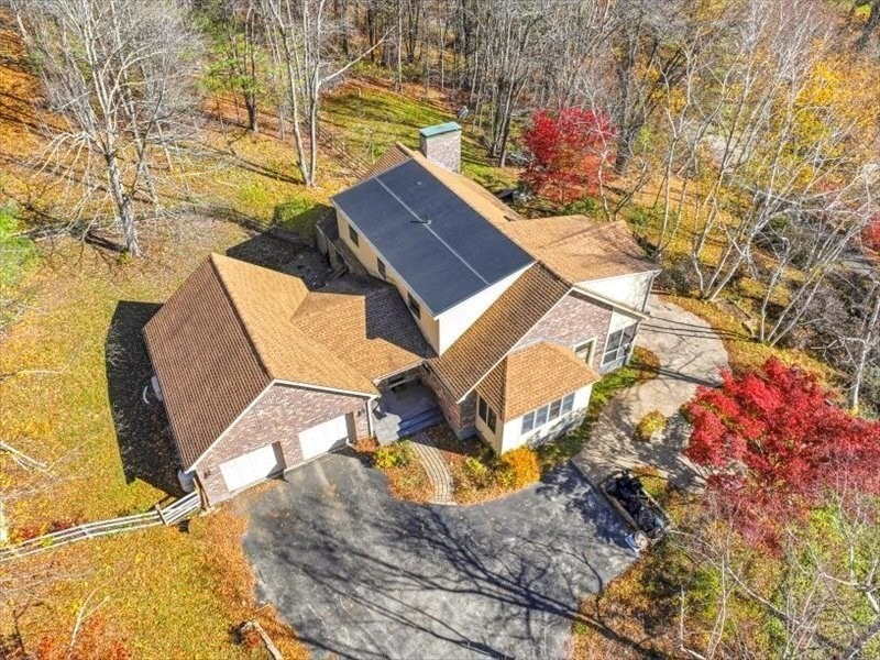
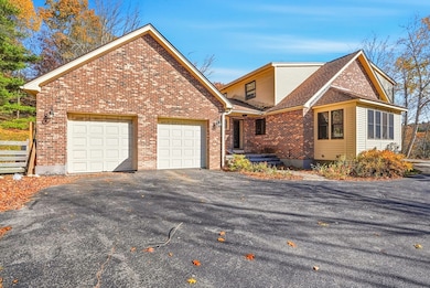
15 N Cove Rd Sterling, MA 01564
Estimated payment $6,083/month
Highlights
- Private Waterfront
- Private Water Access
- Scenic Views
- Wachusett Regional High School Rated A-
- Medical Services
- 2-minute walk to Sholan Park
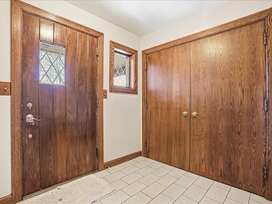
About This Home
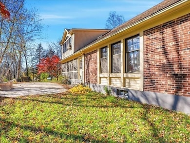
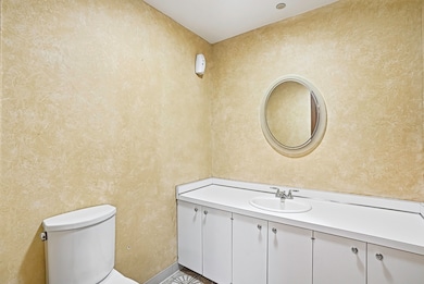
Sterling Lake Waushacum $999900 Brick executive cape features first flooor Main bedroom suite with separate shower,jetted tub,walk in closet and mirrrored vanity. plus additional half bath and laundry.. 2-3 bedrooms and bath upstairs.The deed covers both sides of the street at 15 N Cove. Homesite hillside is somewhat maitanence free with mature white birch and perennials Approximately 3000 s.f first and second floor plus 900' finished basement. Waterfront lot on left side. of the private street features, dock,float ,deck and kayak rack . Driveway is an easement over abutters land. septic replaced 2025. Appliianced kitchen is a gourmet delight with center Island, surface unit, built in oven and microwave. dishwasher, of course. Dining area seats table for 12 Family room adjoins with French doors to sunroom.. formal living with ceiling to floor stone fireplace and beamed cathedral ceiling with overlooking balcony. fourth bedroom upstairs with half round window and cathedral
Home Details
Home Type
- Single Family
Est. Annual Taxes
- $10,067
Year Built
- Built in 1978
Lot Details
- 2.02 Acre Lot
- Private Waterfront
- Property fronts a private road
- Private Streets
- Street terminates at a dead end
- Fenced Yard
- Landscaped Professionally
- Steep Slope
Parking
- 2 Car Attached Garage
- Garage Door Opener
- Driveway
- Open Parking
- Off-Street Parking
Property Views
- Pond
- Scenic Vista
Home Design
- Cape Cod Architecture
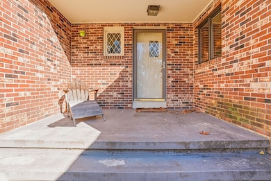
- Brick Exterior Construction
- Frame Construction
- Shingle Roof
- Concrete Perimeter Foundation
Interior Spaces
- Central Vacuum
- Cathedral Ceiling
- Light Fixtures
- Insulated Windows
- Window Screens
- Living Room with Fireplace
- Storm Doors
Kitchen
- Oven
- Range
- Microwave
- Dishwasher
- Wine Refrigerator
Flooring
- Wood
- Carpet
- Stone
- Ceramic Tile
Bedrooms and Bathrooms
- 3 Bedrooms
- Primary Bedroom on Main
- Linen Closet
- Walk-In Closet
- Dressing Area
- Dual Vanity Sinks in Primary Bathroom
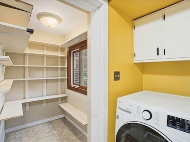
Laundry
- Laundry Room
- Laundry on main level
- Dryer
- Washer
Finished Basement
- Basement Fills Entire Space Under The House
- Interior and Exterior Basement Entry
- Garage Access
Outdoor Features
- Private Water Access
- Enclosed Patio or Porch
Location
- Property is near public transit
- Property is near schools
Schools
- Houghton Elementary School
- Chockett Middle School
- Wachusett Regional High School
Utilities
- Window Unit Cooling System
- 7 Heating Zones
- Heating System Uses Oil
- Baseboard Heating
- Hot Water Heating System
- Electric Baseboard Heater
- Power Generator
- Tankless Water Heater
- Private Sewer
- High Speed Internet
Community Details
- No Home Owners Association
- Medical Services
Listing and Financial Details
- Tax Lot 00050
- Assessor Parcel Number M:00134 L:00050,3430947
Map
Home Values in the Area
Average Home Value in this Area
Tax History
| Year | Tax Paid | Tax Assessment Tax Assessment Total Assessment is a certain percentage of the fair market value that is determined by local assessors to be the total taxable value of land and additions on the property. | Land | Improvement |
|---|---|---|---|---|
| 2025 | $10,067 | $781,600 | $151,700 | $629,900 |
| 2024 | $9,382 | $704,900 | $151,700 | $553,200 |
| 2023 | $9,421 | $658,800 | $152,600 | $506,200 |
| 2022 | $8,967 | $588,000 | $130,800 | $457,200 |
| 2021 | $9,083 | $549,800 | $130,800 | $419,000 |
| 2020 | $8,413 | $500,500 | $130,800 | $369,700 |
| 2019 | $8,055 | $466,400 | $130,800 | $335,600 |
| 2018 | $7,812 | $445,400 | $150,600 | $294,800 |
| 2017 | $8,638 | $479,100 | $139,100 | $340,000 |
| 2016 | $8,051 | $439,200 | $139,100 | $300,100 |
| 2015 | $7,649 | $442,400 | $143,100 | $299,300 |
| 2014 | $7,762 | $458,500 | $146,400 | $312,100 |
Property History
| Date | Event | Price | List to Sale | Price per Sq Ft |
|---|---|---|---|---|
| 11/03/2025 11/03/25 | For Sale | $999,900 | -- | $343 / Sq Ft |
Purchase History
| Date | Type | Sale Price | Title Company |
|---|---|---|---|
| Deed | $550,000 | -- |
Mortgage History
| Date | Status | Loan Amount | Loan Type |
|---|---|---|---|
| Open | $400,000 | Purchase Money Mortgage |
Source: MLS Property Information Network (MLS PIN)
MLS Number: 73450633
APN: STER-000134-000000-000050
Disclaimer: Certain information contained herein is derived from information provided by parties other than Homes.com. All information provided is deemed reliable, but is not guaranteed to be accurate and should be independently verified.
![]() The property listing data and information, or the Images, set forth herein were provided to MLS Property Information Network, Inc. from third party sources, including sellers, lessors and public records, and were compiled by MLS Property Information Network, Inc. The property listing data and information, and the Images, are for the personal, non-commercial use of consumers having a good faith interest in purchasing or leasing listed properties of the type displayed to them and may not be used for any purpose other than to identify prospective properties which such consumers may have a good faith interest in purchasing or leasing. MLS Property Information Network, Inc. and its subscribers disclaim any and all representations and warranties as to the accuracy of the property listing data and information, or as to the accuracy of any of the Images, set forth herein.
The property listing data and information, or the Images, set forth herein were provided to MLS Property Information Network, Inc. from third party sources, including sellers, lessors and public records, and were compiled by MLS Property Information Network, Inc. The property listing data and information, and the Images, are for the personal, non-commercial use of consumers having a good faith interest in purchasing or leasing listed properties of the type displayed to them and may not be used for any purpose other than to identify prospective properties which such consumers may have a good faith interest in purchasing or leasing. MLS Property Information Network, Inc. and its subscribers disclaim any and all representations and warranties as to the accuracy of the property listing data and information, or as to the accuracy of any of the Images, set forth herein.
- 43 Chace Hill Rd
- 19 Fitch Farm Rd
- 21 Myrtle Ave
- 2 Lakeview Ave
- 18 Laurel Ave
- 223 Worcester Rd
- 17 Maple St
- 4 Jewett Rd Unit B
- 4 Jewett Rd Unit A
- 53 Beach Point Rd
- 0 Boutelle Rd
- 5 Leo's Way Unit 1
- 7 Leo's Way Unit 1
- 61 Boutelle Rd
- 45 Meetinghouse Hill Rd
- 290 Sterling St
- 5 Pine Woods Ln
- 96 Clinton Rd
- 54 S Meadow Rd
- 2 Stuart Rd
- 45 Kendall Hill Rd
- 61 Boutelle Rd
- 326 Sterling St Unit C4
- 318 Sterling St Unit E9
- 30 Cottage Ln
- 1-32 Cottage Ln
- 407 Main St
- 71 Flagg St Unit 2
- 92 N Main St Unit C105
- 92 N Main St Unit A327
- 116-118 Lawrence St Unit 2
- 116-118 Lawrence St Unit 1Rear
- 500 Main St
- 63 Union St
- 843 Main St
- 843 Main St Unit 104
- 843 Main St Unit 102
- 18 Alexander Ave
- 44 Nashua St Unit 1
- 46 Grove St
