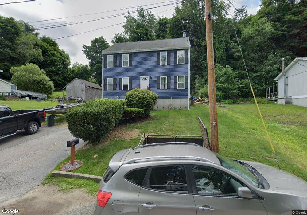
15 Newton St Auburn, MA 01501
Pakachoag NeighborhoodEstimated Value: $421,000 - $466,000
3
Beds
2
Baths
1,536
Sq Ft
$289/Sq Ft
Est. Value
About This Home
This home is located at 15 Newton St, Auburn, MA 01501 and is currently estimated at $443,474, approximately $288 per square foot. 15 Newton St is a home located in Worcester County with nearby schools including Auburn Senior High School, Canterbury Street School, and St Peter Central Catholic Elementary School.
Ownership History
Date
Name
Owned For
Owner Type
Purchase Details
Closed on
Nov 20, 2007
Sold by
Kelson-Facteau Cynthia E and Facteau Gregory S
Bought by
Santon Laura L and Santon Mark J
Current Estimated Value
Home Financials for this Owner
Home Financials are based on the most recent Mortgage that was taken out on this home.
Original Mortgage
$219,500
Interest Rate
6.41%
Mortgage Type
Purchase Money Mortgage
Purchase Details
Closed on
Dec 16, 1996
Sold by
Dascanio Ralph L and Dascanio Lorry
Bought by
Facteau Gregory S and Facteau Cynthia E
Purchase Details
Closed on
Jul 26, 1989
Sold by
M & M Rt
Bought by
Dascanio Ralph
Create a Home Valuation Report for This Property
The Home Valuation Report is an in-depth analysis detailing your home's value as well as a comparison with similar homes in the area
Home Values in the Area
Average Home Value in this Area
Purchase History
| Date | Buyer | Sale Price | Title Company |
|---|---|---|---|
| Santon Laura L | $219,500 | -- | |
| Facteau Gregory S | $120,000 | -- | |
| Dascanio Ralph | $149,900 | -- |
Source: Public Records
Mortgage History
| Date | Status | Borrower | Loan Amount |
|---|---|---|---|
| Open | Dascanio Ralph | $214,250 | |
| Closed | Santon Laura L | $219,500 | |
| Previous Owner | Dascanio Ralph | $160,000 | |
| Previous Owner | Dascanio Ralph | $146,200 |
Source: Public Records
Tax History Compared to Growth
Tax History
| Year | Tax Paid | Tax Assessment Tax Assessment Total Assessment is a certain percentage of the fair market value that is determined by local assessors to be the total taxable value of land and additions on the property. | Land | Improvement |
|---|---|---|---|---|
| 2025 | $53 | $372,300 | $107,300 | $265,000 |
| 2024 | $5,538 | $370,900 | $101,700 | $269,200 |
| 2023 | $5,279 | $332,400 | $92,400 | $240,000 |
| 2022 | $4,456 | $264,900 | $92,400 | $172,500 |
| 2021 | $4,210 | $232,100 | $81,500 | $150,600 |
| 2020 | $4,173 | $232,100 | $81,500 | $150,600 |
| 2019 | $3,868 | $210,000 | $76,400 | $133,600 |
| 2018 | $2,652 | $207,800 | $71,500 | $136,300 |
| 2017 | $3,688 | $201,100 | $64,800 | $136,300 |
| 2016 | $3,642 | $201,300 | $67,700 | $133,600 |
| 2015 | $3,449 | $199,800 | $67,700 | $132,100 |
| 2014 | $3,372 | $195,000 | $64,400 | $130,600 |
Source: Public Records
Map
Nearby Homes