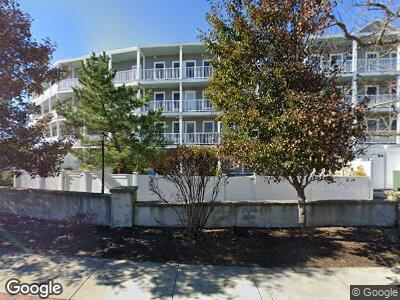
15 Park Ave Unit 205 Hull, MA 02045
Beach Front NeighborhoodEstimated Value: $500,000 - $557,000
2
Beds
2
Baths
1,217
Sq Ft
$430/Sq Ft
Est. Value
About This Home
This home is located at 15 Park Ave Unit 205, Hull, MA 02045 and is currently estimated at $522,973, approximately $429 per square foot. 15 Park Ave Unit 205 is a home with nearby schools including Lillian M. Jacobs Elementary School, Memorial Middle School, and Hull High School.
Ownership History
Date
Name
Owned For
Owner Type
Purchase Details
Closed on
Oct 21, 2021
Sold by
Leatherman John and Leatherman Mary
Bought by
J E & Mary F Latherman Lt
Current Estimated Value
Purchase Details
Closed on
Aug 10, 2020
Sold by
Huynh Hong
Bought by
Leatherman John and Leatherman Mary
Home Financials for this Owner
Home Financials are based on the most recent Mortgage that was taken out on this home.
Original Mortgage
$324,700
Interest Rate
3%
Mortgage Type
New Conventional
Purchase Details
Closed on
Mar 17, 2006
Sold by
Langman Elise M
Bought by
Huynh Hong
Create a Home Valuation Report for This Property
The Home Valuation Report is an in-depth analysis detailing your home's value as well as a comparison with similar homes in the area
Home Values in the Area
Average Home Value in this Area
Purchase History
| Date | Buyer | Sale Price | Title Company |
|---|---|---|---|
| J E & Mary F Latherman Lt | -- | None Available | |
| Leatherman John | $382,000 | None Available | |
| Huynh Hong | $320,000 | -- |
Source: Public Records
Mortgage History
| Date | Status | Borrower | Loan Amount |
|---|---|---|---|
| Previous Owner | Leatherman John | $324,700 |
Source: Public Records
Tax History Compared to Growth
Tax History
| Year | Tax Paid | Tax Assessment Tax Assessment Total Assessment is a certain percentage of the fair market value that is determined by local assessors to be the total taxable value of land and additions on the property. | Land | Improvement |
|---|---|---|---|---|
| 2025 | $4,881 | $435,800 | $0 | $435,800 |
| 2024 | $4,951 | $425,000 | $0 | $425,000 |
| 2023 | $4,852 | $398,700 | $0 | $398,700 |
| 2022 | $4,460 | $355,700 | $0 | $355,700 |
| 2021 | $3,853 | $303,900 | $0 | $303,900 |
| 2020 | $3,906 | $304,700 | $0 | $304,700 |
| 2019 | $3,781 | $289,700 | $0 | $289,700 |
| 2018 | $3,888 | $289,700 | $0 | $289,700 |
| 2017 | $4,180 | $304,700 | $0 | $304,700 |
| 2016 | $3,592 | $266,500 | $0 | $266,500 |
| 2015 | $4,464 | $320,200 | $0 | $320,200 |
| 2014 | $3,954 | $285,100 | $0 | $285,100 |
Source: Public Records
Map
Nearby Homes
- 22 Berkley Rd Unit 3
- 22 Berkley Rd Unit 1
- 22 Berkley Rd Unit 2
- 19 Berkley Rd
- 9 Park Ave Unit 408
- 9 Park Ave Unit 207
- 9 Park Ave Unit 705
- 9 Park Ave Unit 614
- 9 Park Ave Unit 414
- 20 Rockland House Rd Unit 205
- 20 Rockland House Rd Unit 508
- 121 Nantasket Ave Unit 203
- 121 Nantasket Ave Unit 208
- 18 Wyola Rd
- 23 Wyola Rd
- 40 Rockaway Ave
- 29 State Park Rd
- 46 Oceanside Dr Unit 46
- 63 Oceanside Dr Unit PH 63
- 19 Oceanside Dr Unit 19