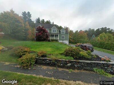
15 Pheasant Run Cir Leominster, MA 01453
West Leominster NeighborhoodEstimated Value: $685,652 - $759,000
4
Beds
3
Baths
2,896
Sq Ft
$255/Sq Ft
Est. Value
About This Home
This home is located at 15 Pheasant Run Cir, Leominster, MA 01453 and is currently estimated at $739,163, approximately $255 per square foot. 15 Pheasant Run Cir is a home located in Worcester County with nearby schools including Leominster High School, St. Leo School, and St. Anna Catholic School.
Ownership History
Date
Name
Owned For
Owner Type
Purchase Details
Closed on
Jun 22, 2022
Sold by
Mcbride Brian N and Keating-Mcbride Catherine
Bought by
Mcbride Lt
Current Estimated Value
Purchase Details
Closed on
Mar 23, 1999
Sold by
Secured Financial Lp
Bought by
Mcbride Brian N and Mcbride Catherine K
Purchase Details
Closed on
Mar 5, 1999
Sold by
Ferandes Alcides
Bought by
Secured Fncl Lp 1
Purchase Details
Closed on
Jul 23, 1998
Sold by
Secured Fincl Lp I
Bought by
Ferandes Alcides
Create a Home Valuation Report for This Property
The Home Valuation Report is an in-depth analysis detailing your home's value as well as a comparison with similar homes in the area
Home Values in the Area
Average Home Value in this Area
Purchase History
| Date | Buyer | Sale Price | Title Company |
|---|---|---|---|
| Mcbride Lt | -- | None Available | |
| Mcbride Brian N | $256,504 | -- | |
| Secured Fncl Lp 1 | $175,000 | -- | |
| Ferandes Alcides | $103,250 | -- |
Source: Public Records
Mortgage History
| Date | Status | Borrower | Loan Amount |
|---|---|---|---|
| Previous Owner | Keating-Mcbride Catherine | $165,000 | |
| Previous Owner | Mcbride Brian N | $20,000 | |
| Previous Owner | Ferandes Alcides | $94,300 | |
| Previous Owner | Ferandes Alcides | $50,000 | |
| Previous Owner | Mcbride Brian N | $135,000 | |
| Previous Owner | Ferandes Alcides | $135,500 |
Source: Public Records
Tax History Compared to Growth
Tax History
| Year | Tax Paid | Tax Assessment Tax Assessment Total Assessment is a certain percentage of the fair market value that is determined by local assessors to be the total taxable value of land and additions on the property. | Land | Improvement |
|---|---|---|---|---|
| 2024 | $8,810 | $607,200 | $204,900 | $402,300 |
| 2023 | $8,322 | $535,500 | $178,300 | $357,200 |
| 2022 | $7,979 | $481,800 | $155,100 | $326,700 |
| 2021 | $7,867 | $433,900 | $120,900 | $313,000 |
| 2020 | $7,692 | $427,800 | $120,900 | $306,900 |
| 2019 | $7,600 | $409,900 | $122,700 | $287,200 |
| 2018 | $7,396 | $382,600 | $111,700 | $270,900 |
| 2017 | $7,207 | $365,300 | $104,300 | $261,000 |
| 2016 | $7,233 | $369,400 | $80,000 | $289,400 |
| 2015 | $6,594 | $339,200 | $80,000 | $259,200 |
| 2014 | $6,587 | $348,700 | $86,100 | $262,600 |
Source: Public Records
Map
Nearby Homes
- 15 Pheasant Run Cir
- 25 Pheasant Run Cir
- 71 Revolution Dr
- 65 Revolution Dr
- 89 Revolution Dr
- 76 Revolution Dr
- 18 Pheasant Run Cir
- 70 Revolution Dr
- 84 Revolution Dr
- 78 Revolution Dr
- 101 Revolution Dr
- 60 Revolution Dr
- 28 Pheasant Run Cir
- 92 Revolution Dr
- 35 Pheasant Run Cir
- 36 Pheasant Run Cir
- 109 Revolution Dr
- 53 Pheasant Run Cir
- 59 Revolution Dr
- 76 Sheldon Hill Dr