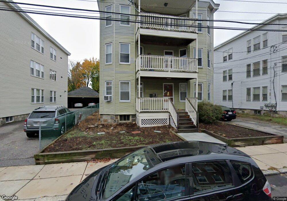
15 Ransom Rd Brighton, MA 02135
Saint Elizabeths NeighborhoodEstimated Value: $1,614,000 - $2,290,000
3
Beds
4
Baths
1,000
Sq Ft
$1,958/Sq Ft
Est. Value
About This Home
This home is located at 15 Ransom Rd, Brighton, MA 02135 and is currently estimated at $1,957,667, approximately $1,957 per square foot. 15 Ransom Rd is a home located in Suffolk County with nearby schools including Boston Green Academy Horace Mann Charter School, Shaloh House Jewish Day School, and Torah Academy.
Ownership History
Date
Name
Owned For
Owner Type
Purchase Details
Closed on
Aug 18, 1988
Sold by
J-Ja Rlty Tr
Bought by
Lee Paul
Current Estimated Value
Purchase Details
Closed on
Jun 23, 1988
Sold by
Eva Rt
Bought by
Cruise James R
Purchase Details
Closed on
Jun 15, 1988
Sold by
Chan Nelson
Bought by
Chin James
Purchase Details
Closed on
May 17, 1988
Sold by
Eva Rlty Tr
Bought by
Schumar Kathleen M
Purchase Details
Closed on
Dec 30, 1987
Sold by
Eva Rt
Bought by
Mintz Morris D
Purchase Details
Closed on
Dec 23, 1987
Sold by
Eva Rlty Tr
Bought by
Palumbo David
Purchase Details
Closed on
Dec 22, 1987
Sold by
Eva Rt
Bought by
Loring Steven S
Create a Home Valuation Report for This Property
The Home Valuation Report is an in-depth analysis detailing your home's value as well as a comparison with similar homes in the area
Home Values in the Area
Average Home Value in this Area
Purchase History
| Date | Buyer | Sale Price | Title Company |
|---|---|---|---|
| Lee Paul | $295,000 | -- | |
| Cruise James R | $115,920 | -- | |
| Chin James | $295,000 | -- | |
| Schumar Kathleen M | $105,000 | -- | |
| Mintz Morris D | $89,000 | -- | |
| Palumbo David | $46,000 | -- | |
| Loring Steven S | $59,000 | -- |
Source: Public Records
Mortgage History
| Date | Status | Borrower | Loan Amount |
|---|---|---|---|
| Open | Loring Steven S | $650,000 | |
| Closed | Loring Steven S | $560,000 |
Source: Public Records
Property History
| Date | Event | Price | List to Sale | Price per Sq Ft |
|---|---|---|---|---|
| 10/08/2024 10/08/24 | Off Market | $3,600 | -- | -- |
| 03/01/2024 03/01/24 | For Rent | $3,600 | -- | -- |
Tax History Compared to Growth
Tax History
| Year | Tax Paid | Tax Assessment Tax Assessment Total Assessment is a certain percentage of the fair market value that is determined by local assessors to be the total taxable value of land and additions on the property. | Land | Improvement |
|---|---|---|---|---|
| 2025 | $23,037 | $1,989,400 | $615,600 | $1,373,800 |
| 2024 | $21,064 | $1,932,500 | $536,500 | $1,396,000 |
| 2023 | $19,757 | $1,839,600 | $510,700 | $1,328,900 |
| 2022 | $19,820 | $1,821,700 | $505,700 | $1,316,000 |
| 2021 | $19,057 | $1,786,000 | $495,800 | $1,290,200 |
| 2020 | $17,537 | $1,660,700 | $476,700 | $1,184,000 |
| 2019 | $16,371 | $1,553,200 | $375,500 | $1,177,700 |
| 2018 | $15,428 | $1,472,100 | $373,700 | $1,098,400 |
| 2017 | $14,847 | $1,402,000 | $373,700 | $1,028,300 |
| 2016 | $13,770 | $1,251,800 | $373,700 | $878,100 |
| 2015 | $12,838 | $1,060,100 | $291,000 | $769,100 |
| 2014 | $11,587 | $921,100 | $291,000 | $630,100 |
Source: Public Records
Map
Nearby Homes
- 1641 Commonwealth Ave Unit 20
- 1607 Commonwealth Ave Unit 14
- 38 Ransom Rd Unit 12
- 1669 Commonwealth Ave Unit 3
- 1650 Commonwealth Ave Unit 304
- 36 Colborne Rd
- 1666 Commonwealth Ave Unit 24
- 1564 Commonwealth Ave Unit 3
- 1691 Commonwealth Ave Unit 31
- 2 Larose Place Unit 13
- 36 Cummings Rd Unit 1
- 1710 Commonwealth Ave Unit 3
- 123 Nottinghill Rd Unit 1
- 190 Corey Rd Unit 5
- 57 Nottinghill Rd
- 85 Williston Rd
- 1515 Commonwealth Ave Unit 405
- 1515 Commonwealth Ave Unit 303
- 1515 Commonwealth Ave Unit 311
- 1515 Commonwealth Ave Unit 514
- 15 Ransom Rd
- 15 Ransom Rd Unit 1
- 11 Ransom Rd
- 11 Ransom Rd Unit 5
- 11 Ransom Rd
- 11 Ransom Rd Unit 2
- 11 Ransom Rd Unit 3
- 11 Ransom Rd Unit 1
- 19 Ransom Rd Unit 3
- 19 Ransom Rd
- 19 Ransom Rd Unit 1
- 21 Ransom Rd Unit 3
- 79 Euston Rd
- 79 Euston Rd Unit 3
- 23 Ransom Rd
- 23 Ransom Rd Unit 3
- 23 Ransom Rd Unit 1
- 23 Ransom Rd Unit 2
- 23 Ransom Rd
- 23 Ransom Rd Unit 3