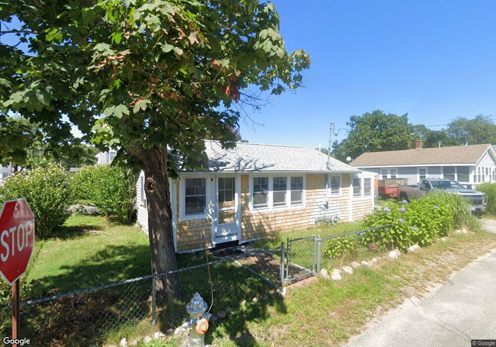
15 Swift Ave Wareham, MA 02571
Wareham Center NeighborhoodEstimated Value: $311,030 - $350,000
2
Beds
1
Bath
543
Sq Ft
$620/Sq Ft
Est. Value
About This Home
This home is located at 15 Swift Ave, Wareham, MA 02571 and is currently estimated at $336,508, approximately $619 per square foot. 15 Swift Ave is a home located in Plymouth County.
Ownership History
Date
Name
Owned For
Owner Type
Purchase Details
Closed on
Oct 28, 2022
Sold by
Korkuch Tess
Bought by
Minichiello Robert M and Minichiello Elisabeth W
Current Estimated Value
Purchase Details
Closed on
Mar 21, 2022
Sold by
Taylor Gary W
Bought by
Taylor Ryan M
Purchase Details
Closed on
Mar 30, 2017
Sold by
Deutsche Bk Natl T Co
Bought by
Korkuch Tess
Purchase Details
Closed on
Mar 16, 2016
Sold by
Merigold Carol and Deutsche Bk Natl T Co
Bought by
Deutsche Bk Natl T Co
Purchase Details
Closed on
Sep 22, 2006
Sold by
Coffey Paul
Bought by
Merigold David E and Merigold Carol
Home Financials for this Owner
Home Financials are based on the most recent Mortgage that was taken out on this home.
Original Mortgage
$212,000
Interest Rate
6.59%
Mortgage Type
Purchase Money Mortgage
Purchase Details
Closed on
Feb 10, 1997
Sold by
Nationscredit Fncl Svc
Bought by
Coffey Paul
Purchase Details
Closed on
May 24, 1996
Sold by
Ohrenberger Paul J
Bought by
Nationscredit Fncl Svc
Create a Home Valuation Report for This Property
The Home Valuation Report is an in-depth analysis detailing your home's value as well as a comparison with similar homes in the area
Home Values in the Area
Average Home Value in this Area
Purchase History
| Date | Buyer | Sale Price | Title Company |
|---|---|---|---|
| Minichiello Robert M | $250,000 | None Available | |
| Minichiello Robert M | $250,000 | None Available | |
| Taylor Ryan M | -- | None Available | |
| Korkuch Tess | $115,000 | -- | |
| Korkuch Tess | $115,000 | -- | |
| Deutsche Bk Natl T Co | $105,000 | -- | |
| Deutsche Bk Natl T Co | $105,000 | -- | |
| Merigold David E | $212,000 | -- | |
| Merigold David E | $212,000 | -- | |
| Coffey Paul | $38,000 | -- | |
| Coffey Paul | $38,000 | -- | |
| Nationscredit Fncl Svc | $54,622 | -- | |
| Nationscredit Fncl Svc | $54,622 | -- |
Source: Public Records
Mortgage History
| Date | Status | Borrower | Loan Amount |
|---|---|---|---|
| Previous Owner | Nationscredit Fncl Svc | $16,000 | |
| Previous Owner | Nationscredit Fncl Svc | $222,000 | |
| Previous Owner | Nationscredit Fncl Svc | $212,000 |
Source: Public Records
Tax History
| Year | Tax Paid | Tax Assessment Tax Assessment Total Assessment is a certain percentage of the fair market value that is determined by local assessors to be the total taxable value of land and additions on the property. | Land | Improvement |
|---|---|---|---|---|
| 2025 | $3,113 | $298,800 | $106,600 | $192,200 |
| 2024 | $3,120 | $277,800 | $79,600 | $198,200 |
| 2023 | $2,446 | $219,900 | $72,400 | $147,500 |
| 2022 | $2,446 | $185,600 | $72,400 | $113,200 |
| 2021 | $2,288 | $170,100 | $72,400 | $97,700 |
| 2020 | $2,176 | $164,100 | $72,400 | $91,700 |
| 2019 | $1,919 | $144,400 | $64,700 | $79,700 |
| 2018 | $1,443 | $105,900 | $64,700 | $41,200 |
| 2017 | $1,369 | $101,800 | $64,700 | $37,100 |
| 2016 | $1,269 | $93,800 | $61,600 | $32,200 |
| 2015 | $1,226 | $93,800 | $61,600 | $32,200 |
| 2014 | $1,546 | $120,300 | $61,600 | $58,700 |
Source: Public Records
Map
Nearby Homes
- 21 Bayview St
- 43 Shore Ave
- 20 Grant St
- 10 Barnes St
- 6 Allen Ave
- 15 Broadmarsh Ave
- 58 Shady Ln
- 0 Cromesett Rd (Off) Unit 73385395
- 1 Nimrod Way
- 4 Roosevelt St
- 14 Briarwood Dr
- 233 Marion Rd
- 12 Taft St
- 9 Woodville Way
- 6 Bourne Terrace
- 10 Longmeadow Dr
- 10 Oak St
- 0 Cross Neck Rd Unit 73420524
- 0 Cross Neck Rd Unit 73466177
- 0 Cross Neck Rd Unit 73420525
Your Personal Tour Guide
Ask me questions while you tour the home.