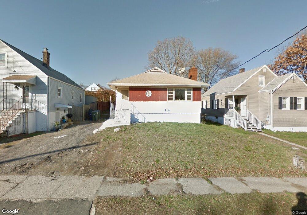
150 Baker St Bridgeport, CT 06606
North End NeighborhoodEstimated Value: $362,000 - $479,000
3
Beds
1
Bath
1,216
Sq Ft
$341/Sq Ft
Est. Value
About This Home
This home is located at 150 Baker St, Bridgeport, CT 06606 and is currently estimated at $414,775, approximately $341 per square foot. 150 Baker St is a home located in Fairfield County with nearby schools including Blackham School, Central High School, and Assumption Catholic School.
Ownership History
Date
Name
Owned For
Owner Type
Purchase Details
Closed on
May 22, 2017
Sold by
Esposito Lawrence
Bought by
Defilippo Michael
Current Estimated Value
Home Financials for this Owner
Home Financials are based on the most recent Mortgage that was taken out on this home.
Original Mortgage
$140,760
Interest Rate
4.1%
Mortgage Type
Commercial
Purchase Details
Closed on
Apr 26, 1999
Sold by
Esposito Anthony J and Esposito Sandra
Bought by
Esposito Lawrence B
Create a Home Valuation Report for This Property
The Home Valuation Report is an in-depth analysis detailing your home's value as well as a comparison with similar homes in the area
Home Values in the Area
Average Home Value in this Area
Purchase History
| Date | Buyer | Sale Price | Title Company |
|---|---|---|---|
| Defilippo Michael | $138,000 | -- | |
| Defilippo Michael | $138,000 | -- | |
| Esposito Lawrence B | $112,050 | -- | |
| Esposito Lawrence B | $112,050 | -- |
Source: Public Records
Mortgage History
| Date | Status | Borrower | Loan Amount |
|---|---|---|---|
| Open | Esposito Lawrence B | $148,000 | |
| Closed | Esposito Lawrence B | $148,000 | |
| Closed | Esposito Lawrence B | $140,760 |
Source: Public Records
Tax History Compared to Growth
Tax History
| Year | Tax Paid | Tax Assessment Tax Assessment Total Assessment is a certain percentage of the fair market value that is determined by local assessors to be the total taxable value of land and additions on the property. | Land | Improvement |
|---|---|---|---|---|
| 2025 | $6,091 | $140,190 | $75,310 | $64,880 |
| 2024 | $6,091 | $140,190 | $75,310 | $64,880 |
| 2023 | $6,091 | $140,190 | $75,310 | $64,880 |
| 2022 | $6,091 | $140,190 | $75,310 | $64,880 |
| 2021 | $6,091 | $140,190 | $75,310 | $64,880 |
| 2020 | $5,147 | $95,330 | $39,340 | $55,990 |
| 2019 | $5,147 | $95,330 | $39,340 | $55,990 |
| 2018 | $5,183 | $95,330 | $39,340 | $55,990 |
| 2017 | $5,183 | $95,330 | $39,340 | $55,990 |
| 2016 | $5,183 | $95,330 | $39,340 | $55,990 |
| 2015 | $5,195 | $123,100 | $47,600 | $75,500 |
| 2014 | $5,195 | $123,100 | $47,600 | $75,500 |
Source: Public Records
Map
Nearby Homes
- 783 Clark St
- 932 Thorme St
- 3200 Park Ave Unit 11C2
- 3200 Park Ave Unit 11E2
- 681 Westfield Ave
- 3430 Park Ave
- 3450 Park Ave
- 520 Savoy St
- 605 Merritt St
- 604 Birmingham St
- 720 Queen St
- 485 Westfield Ave
- 376 Savoy St
- 226 Alberta St
- 375 Ruth St
- 129 Ashton St
- 631 Fairview Ave
- 105 Tremont Ave Unit E
- 105 Tremont Ave Unit B
- 161 Brion Dr
- 162 Northfield St
- 795 Thorme St
- 805 Thorme St
- 1985 Madison Ave
- 1975 Madison Ave
- 140 Baker St
- 1995 Madison Ave
- 155 Baker St
- 145 Baker St
- 1963 Madison Ave
- 135 Baker St
- 183 Northfield St
- 156 Northfield St
- 825 Thorme St
- 163 Northfield St
- 125 Baker St
- 835 Thorme St
- 1939 Madison Ave
- 820 Thorme St
- 430 Flint St