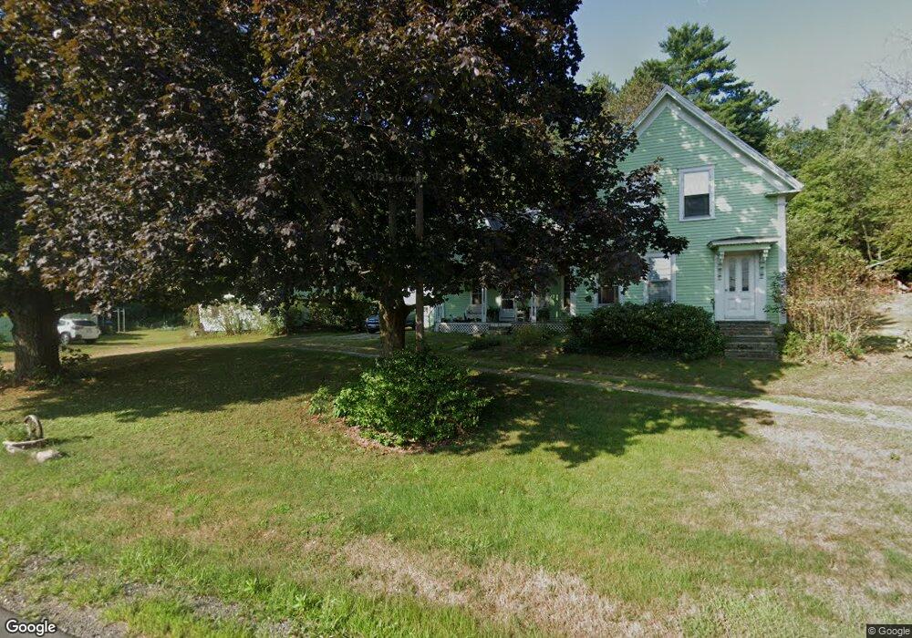
150 West River Rd Hooksett, NH 03106
Estimated Value: $511,000 - $757,000
4
Beds
2
Baths
2,237
Sq Ft
$271/Sq Ft
Est. Value
About This Home
This home is located at 150 West River Rd, Hooksett, NH 03106 and is currently estimated at $605,511, approximately $270 per square foot. 150 West River Rd is a home located in Merrimack County with nearby schools including Fred C. Underhill School, Hooksett Memorial School, and David R. Cawley Middle School.
Ownership History
Date
Name
Owned For
Owner Type
Purchase Details
Closed on
Oct 17, 2019
Sold by
Gorton Patricia D
Bought by
James Gorton Ft
Current Estimated Value
Purchase Details
Closed on
Jul 2, 2018
Sold by
Dorothy A Dobrowski Re
Bought by
Gorton Patricia D
Purchase Details
Closed on
Feb 15, 2018
Sold by
Dorothy A Dobrowski Re
Bought by
Gorton Patricia D
Create a Home Valuation Report for This Property
The Home Valuation Report is an in-depth analysis detailing your home's value as well as a comparison with similar homes in the area
Home Values in the Area
Average Home Value in this Area
Purchase History
| Date | Buyer | Sale Price | Title Company |
|---|---|---|---|
| James Gorton Ft | -- | -- | |
| Gorton Patricia D | -- | -- | |
| Dorothy A Dobrowski Re | -- | -- | |
| Gorton Patricia D | -- | -- | |
| Gorton Patricia D | -- | -- | |
| Dobrowski George H | -- | -- |
Source: Public Records
Tax History
| Year | Tax Paid | Tax Assessment Tax Assessment Total Assessment is a certain percentage of the fair market value that is determined by local assessors to be the total taxable value of land and additions on the property. | Land | Improvement |
|---|---|---|---|---|
| 2024 | $7,415 | $437,231 | $124,931 | $312,300 |
| 2023 | $6,974 | $436,431 | $124,131 | $312,300 |
| 2022 | $6,509 | $270,663 | $85,963 | $184,700 |
| 2021 | $6,014 | $270,663 | $85,963 | $184,700 |
| 2020 | $6,093 | $270,663 | $85,963 | $184,700 |
| 2019 | $5,833 | $270,663 | $85,963 | $184,700 |
| 2018 | $5,989 | $270,750 | $86,050 | $184,700 |
| 2017 | $5,832 | $218,115 | $82,315 | $135,800 |
| 2016 | $5,756 | $218,115 | $82,315 | $135,800 |
| 2015 | $5,391 | $218,090 | $82,290 | $135,800 |
| 2014 | $5,415 | $218,090 | $82,290 | $135,800 |
| 2013 | $5,126 | $218,313 | $82,513 | $135,800 |
Source: Public Records
Map
Nearby Homes
- 245 W River Rd
- 5 Cross Rd
- 315 Hackett Hill Rd
- 1465 Hooksett Rd Unit 418
- 1465 Hooksett Rd Unit 183
- 1465 Hooksett Rd Unit 390
- 1465 Hooksett Rd Unit 41
- 620 Hackett Hill Rd Unit B007
- 9 Lancelot Dr
- 32 Lindsay Rd
- 8 Harvest Dr
- 190 Chase Way
- 1601 Hooksett Rd
- 141 Chase Way
- 90 Golfview Dr
- 286B Londonderry Turnpike Unit A
- 15 Northbrook Dr Unit 1512
- 62 Harold St
- 9 Berry Hill Rd
- 14 Northbrook Dr Unit 1410
- 142 West River Rd
- 5 River Field Path
- 143 West River Rd
- 143 West River Rd Unit 44
- 3 River Field Path
- 143 W River Rd
- 138 West River Rd
- 141 W River Rd
- 4 River Field Path
- 134 West River Rd
- 6 River Field Path
- 137 West River Rd
- 137 West River Rd
- 9 Sunrise Blvd
- 2 Sunrise Blvd
- 7 Sunrise Blvd
- 135 West River Rd
- 2 Gullane Rd
- 135 West River Rd
- 6 Gullane Rd
Your Personal Tour Guide
Ask me questions while you tour the home.