C
Seller's Agent in 2013
Cory Sanders
Sanders & Company
(217) 235-4848
58 in this area
139 Total Sales

Estimated Value: $173,000 - $226,000
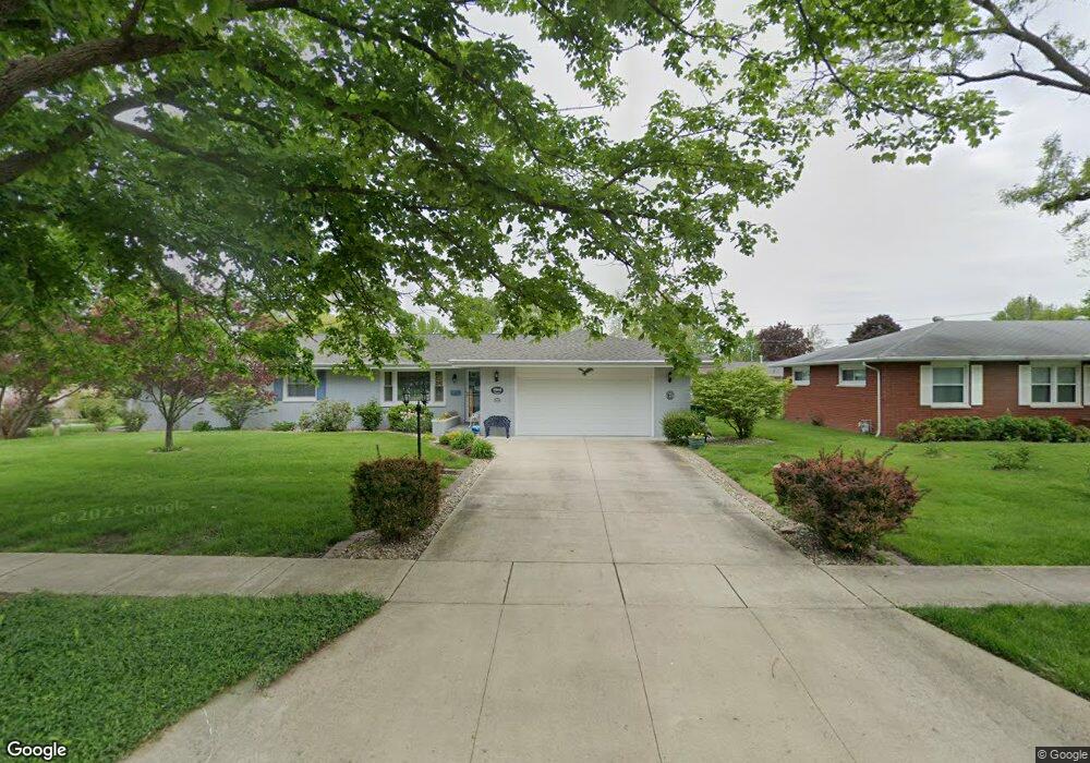
Property is a nice brick home in good neighborhood. Needs some TLC, but priced to sell.
Last Agent to Sell the Property
Sanders & Company License #471003576 Listed on: 03/28/2013
| Date | Buyer | Sale Price | Title Company |
|---|---|---|---|
| Bridges John F | $113,333 | None Listed On Document | |
| Mckittrick Trust | $126,500 | -- | |
| Daily Pamela L | $75,100 | None Available | |
| Citifinancial Inc | -- | None Available |
| Date | Event | Price | List to Sale | Price per Sq Ft |
|---|---|---|---|---|
| 06/14/2013 06/14/13 | Sold | $75,100 | 0.0% | $45 / Sq Ft |
| 05/28/2013 05/28/13 | Pending | -- | -- | -- |
| 03/28/2013 03/28/13 | For Sale | $75,100 | -- | $45 / Sq Ft |
| Year | Tax Paid | Tax Assessment Tax Assessment Total Assessment is a certain percentage of the fair market value that is determined by local assessors to be the total taxable value of land and additions on the property. | Land | Improvement |
|---|---|---|---|---|
| 2024 | $3,856 | $51,378 | $6,587 | $44,791 |
| 2023 | $2,984 | $45,873 | $5,881 | $39,992 |
| 2022 | $2,984 | $45,115 | $5,784 | $39,331 |
| 2021 | $2,953 | $41,440 | $9,061 | $32,379 |
| 2020 | $2,912 | $42,936 | $9,388 | $33,548 |
| 2019 | $2,437 | $37,213 | $9,061 | $28,152 |
| 2018 | $2,396 | $37,213 | $9,061 | $28,152 |
| 2017 | $2,388 | $37,213 | $9,061 | $28,152 |
| 2016 | $2,340 | $37,213 | $9,061 | $28,152 |
| 2015 | $2,752 | $37,213 | $9,061 | $28,152 |
| 2014 | $2,752 | $37,213 | $9,061 | $28,152 |
| 2013 | $2,752 | $37,213 | $9,061 | $28,152 |
C
Seller's Agent in 2013
Cory Sanders
Sanders & Company
(217) 235-4848
58 in this area
139 Total Sales

Buyer's Agent in 2013
Julie Willingham
Premier Realtors
(217) 273-9039
133 in this area
230 Total Sales
Source: Central Illinois Board of REALTORS®
MLS Number: 4218078
APN: 07-1-07053-000
Ask me questions while you tour the home.