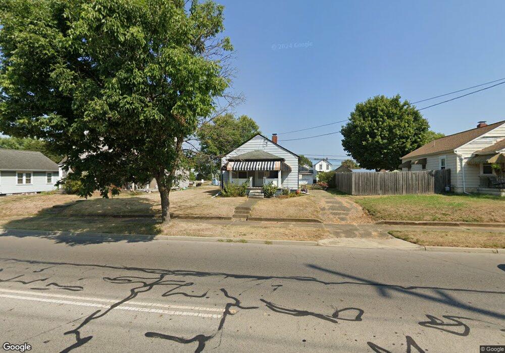
1501 W Fair Ave Lancaster, OH 43130
Estimated Value: $137,435 - $159,000
2
Beds
1
Bath
704
Sq Ft
$214/Sq Ft
Est. Value
About This Home
This home is located at 1501 W Fair Ave, Lancaster, OH 43130 and is currently estimated at $150,609, approximately $213 per square foot. 1501 W Fair Ave is a home located in Fairfield County with nearby schools including General Sherman Junior High School, Lancaster High School, and St Mary Elementary School.
Ownership History
Date
Name
Owned For
Owner Type
Purchase Details
Closed on
Jul 24, 2009
Sold by
Triad Dominion Equities Llc
Bought by
Milisits Megan and Milisits Eric S
Current Estimated Value
Purchase Details
Closed on
May 28, 2009
Sold by
Cope Diana L and Sherlock Carl D
Bought by
Triad Dominion Equities Llc
Purchase Details
Closed on
May 15, 2002
Sold by
Tipple Holly R
Bought by
Cope Diana L and Sherlock Carl D
Home Financials for this Owner
Home Financials are based on the most recent Mortgage that was taken out on this home.
Original Mortgage
$27,960
Interest Rate
7.16%
Mortgage Type
Balloon
Purchase Details
Closed on
Jul 18, 1991
Sold by
Butts Anna R
Bought by
Tipple Michael J
Create a Home Valuation Report for This Property
The Home Valuation Report is an in-depth analysis detailing your home's value as well as a comparison with similar homes in the area
Home Values in the Area
Average Home Value in this Area
Purchase History
| Date | Buyer | Sale Price | Title Company |
|---|---|---|---|
| Milisits Megan | $26,000 | Prism Title & Closing Servic | |
| Triad Dominion Equities Llc | -- | Attorney | |
| Cope Diana L | $69,900 | -- | |
| Tipple Michael J | $35,000 | -- |
Source: Public Records
Mortgage History
| Date | Status | Borrower | Loan Amount |
|---|---|---|---|
| Previous Owner | Cope Diana L | $27,960 |
Source: Public Records
Tax History Compared to Growth
Tax History
| Year | Tax Paid | Tax Assessment Tax Assessment Total Assessment is a certain percentage of the fair market value that is determined by local assessors to be the total taxable value of land and additions on the property. | Land | Improvement |
|---|---|---|---|---|
| 2024 | $2,619 | $29,130 | $7,230 | $21,900 |
| 2023 | $1,111 | $29,130 | $7,230 | $21,900 |
| 2022 | $1,114 | $29,130 | $7,230 | $21,900 |
| 2021 | $919 | $22,430 | $7,230 | $15,200 |
| 2020 | $294 | $22,430 | $7,230 | $15,200 |
| 2019 | $842 | $22,430 | $7,230 | $15,200 |
| 2018 | $425 | $18,280 | $7,230 | $11,050 |
| 2017 | $710 | $18,280 | $7,230 | $11,050 |
| 2016 | $692 | $18,280 | $7,230 | $11,050 |
| 2015 | $706 | $18,330 | $7,230 | $11,100 |
| 2014 | $674 | $18,330 | $7,230 | $11,100 |
| 2013 | $674 | $18,330 | $7,230 | $11,100 |
Source: Public Records
Map
Nearby Homes
- 1628 W Fair Ave
- 953 Garfield Ave
- 517 Busby Ave
- 539 N Ohio Ave
- 844 Washington Ave
- 635 Brannon Dr
- 936 Harrison Ave
- 1935 Smith Ave
- 628 Harrison Ave
- 1000 Goodwin Ave
- 404 Garfield Ave
- 429 Harrison Ave
- 1829 Shoshone Dr
- 317 Harrison Ave
- 226 Whittier Dr S
- 140 Sherman Ave
- 136 Sherman Ave
- 525 N Zane Ave
- 1511 Cedar Hill Rd
- 603 Edgewood Ave
- 1433 W Fair Ave
- 1503 W Fair Ave
- 1429 W Fair Ave
- 1505 W Fair Ave
- 1500 Graylock St
- 1423 W Fair Ave
- 1515 W Fair Ave
- 1510 Graylock St
- 1518 Graylock St
- 1426 Graylock St
- 1419 W Fair Ave
- 1521 W Fair Ave
- 1422 Graylock St
- 1520 Graylock St
- 1500 W Fair Ave
- 1504 W Fair Ave
- 1430 W Fair Ave
- 1418 Graylock St
- 916 Green Ave
- 1424 W Fair Ave