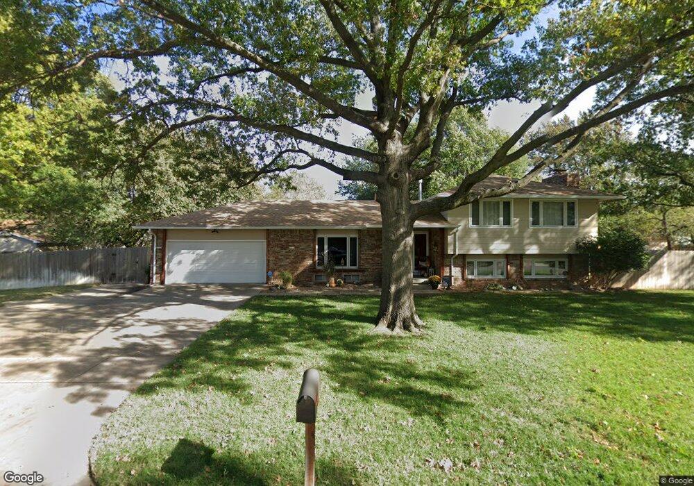
1502 N Murray St Wichita, KS 67212
West Wichita NeighborhoodEstimated Value: $235,000 - $256,799
3
Beds
2
Baths
1,344
Sq Ft
$183/Sq Ft
Est. Value
About This Home
This home is located at 1502 N Murray St, Wichita, KS 67212 and is currently estimated at $245,900, approximately $182 per square foot. 1502 N Murray St is a home located in Sedgwick County with nearby schools including McCollom Elementary School, Wilbur Middle School, and Wichita Northwest High School.
Ownership History
Date
Name
Owned For
Owner Type
Purchase Details
Closed on
May 23, 2023
Sold by
Macmeeken Ronald A and Macmeeken Kristian L
Bought by
Macmeeken Trust and Macmeeken
Current Estimated Value
Purchase Details
Closed on
Nov 1, 2006
Sold by
Chasmore David M and Chasmore Cassandra L
Bought by
Macmeehan Ronald A and Macmeehan Kristian L
Home Financials for this Owner
Home Financials are based on the most recent Mortgage that was taken out on this home.
Original Mortgage
$143,010
Interest Rate
6.26%
Mortgage Type
VA
Create a Home Valuation Report for This Property
The Home Valuation Report is an in-depth analysis detailing your home's value as well as a comparison with similar homes in the area
Home Values in the Area
Average Home Value in this Area
Purchase History
| Date | Buyer | Sale Price | Title Company |
|---|---|---|---|
| Macmeeken Trust | -- | None Listed On Document | |
| Macmeehan Ronald A | -- | None Available |
Source: Public Records
Mortgage History
| Date | Status | Borrower | Loan Amount |
|---|---|---|---|
| Previous Owner | Macmeehan Ronald A | $143,010 |
Source: Public Records
Tax History Compared to Growth
Tax History
| Year | Tax Paid | Tax Assessment Tax Assessment Total Assessment is a certain percentage of the fair market value that is determined by local assessors to be the total taxable value of land and additions on the property. | Land | Improvement |
|---|---|---|---|---|
| 2025 | $2,374 | $23,771 | $5,704 | $18,067 |
| 2023 | $2,374 | $20,425 | $3,669 | $16,756 |
| 2022 | $2,068 | $18,688 | $3,462 | $15,226 |
| 2021 | $1,972 | $17,308 | $2,829 | $14,479 |
| 2020 | $1,980 | $17,308 | $2,829 | $14,479 |
| 2019 | $1,799 | $15,732 | $2,829 | $12,903 |
| 2018 | $1,750 | $15,273 | $2,128 | $13,145 |
| 2017 | $1,666 | $0 | $0 | $0 |
| 2016 | $1,614 | $0 | $0 | $0 |
| 2015 | $1,602 | $0 | $0 | $0 |
| 2014 | $1,569 | $0 | $0 | $0 |
Source: Public Records
Map
Nearby Homes
- 9336 W Briarwood Ct
- 1548 N Amarado Ct
- 1534 N Valleyview Ct
- 9026 W Harvest Ct
- 1736 N Amarado St
- 1671 N Maybelle St
- 9117 W Westport St
- 8930 W Suncrest St
- 9221 W Suncrest St
- 9804 W 12th St N
- 9801 W 12th St N
- 1842 N Cheryl Ct
- 8608 W Nantucket St
- 8803 W 18th Ct N
- 8911 W Jamesburg St
- 10119 W Westport St
- 9706 W Bella Vista St
- 1112 N Westfield Ave
- 10246 W Westport St
- 1138 N Chipper Ln
- 9443 W Thurman St
- 1505 N Murray St
- 9408 W Nantucket St
- 1501 N Murray St
- 9433 W Thurman St
- 1444 N Murray St
- 1445 N Murray St
- 1513 N Murray St
- 9411 W Nantucket St
- 9421 W Thurman St
- 9402 W Nantucket St
- 1435 N Murray St
- 1523 N Murray St
- 9403 W Nantucket St
- 9409 W Thurman St
- 1425 N Murray St
- 1434 N Murray Ct
- 1604 N Murray St
- 9325 W Nantucket St
- 9322 W Nantucket St