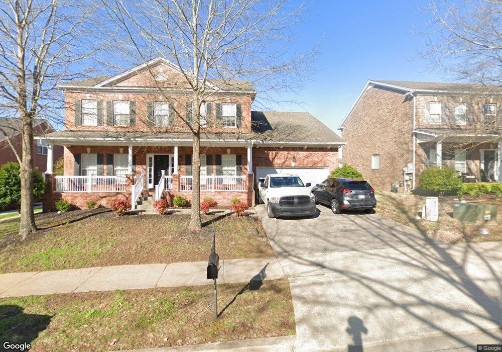
1503 Braden Cir Franklin, TN 37067
Estimated Value: $791,003 - $847,000
--
Bed
4
Baths
2,960
Sq Ft
$277/Sq Ft
Est. Value
About This Home
This home is located at 1503 Braden Cir, Franklin, TN 37067 and is currently estimated at $819,751, approximately $276 per square foot. 1503 Braden Cir is a home located in Williamson County with nearby schools including Clovercroft Elementary School, Fred J. Page Middle School, and Centennial High School.
Ownership History
Date
Name
Owned For
Owner Type
Purchase Details
Closed on
Feb 25, 2005
Sold by
The Jones Co Of Tennessee Llc
Bought by
Ussery David E and Ussery Sara A
Current Estimated Value
Home Financials for this Owner
Home Financials are based on the most recent Mortgage that was taken out on this home.
Original Mortgage
$236,450
Outstanding Balance
$119,953
Interest Rate
5.62%
Mortgage Type
Purchase Money Mortgage
Estimated Equity
$699,798
Purchase Details
Closed on
Dec 14, 2004
Sold by
Jones Land Co Llc
Bought by
The Jones Co Of Tennessee Llc
Create a Home Valuation Report for This Property
The Home Valuation Report is an in-depth analysis detailing your home's value as well as a comparison with similar homes in the area
Home Values in the Area
Average Home Value in this Area
Purchase History
| Date | Buyer | Sale Price | Title Company |
|---|---|---|---|
| Ussery David E | $296,554 | Southland Title & Escrow Co | |
| The Jones Co Of Tennessee Llc | -- | Southland |
Source: Public Records
Mortgage History
| Date | Status | Borrower | Loan Amount |
|---|---|---|---|
| Open | Ussery David E | $236,450 | |
| Closed | Ussery David E | $45,300 |
Source: Public Records
Tax History Compared to Growth
Tax History
| Year | Tax Paid | Tax Assessment Tax Assessment Total Assessment is a certain percentage of the fair market value that is determined by local assessors to be the total taxable value of land and additions on the property. | Land | Improvement |
|---|---|---|---|---|
| 2024 | $2,771 | $128,500 | $25,000 | $103,500 |
| 2023 | $2,771 | $128,500 | $25,000 | $103,500 |
| 2022 | $2,771 | $128,500 | $25,000 | $103,500 |
| 2021 | $2,771 | $128,500 | $25,000 | $103,500 |
| 2020 | $2,555 | $99,125 | $21,250 | $77,875 |
| 2019 | $2,555 | $99,125 | $21,250 | $77,875 |
| 2018 | $2,486 | $99,125 | $21,250 | $77,875 |
| 2017 | $2,466 | $99,125 | $21,250 | $77,875 |
| 2016 | $2,436 | $99,125 | $21,250 | $77,875 |
| 2015 | -- | $81,725 | $18,750 | $62,975 |
| 2014 | -- | $81,725 | $18,750 | $62,975 |
Source: Public Records
Map
Nearby Homes
- 1407 Hanson Dr
- 1422 Marrimans Ct
- 6060 Lookaway Cir
- 6035 Lookaway Cir
- 1068 Amelia Park Dr
- 1055 Amelia Park Dr
- 1132 Amelia Park Dr
- 4165 Clovercroft Rd
- 1607 Sand Dollar Ct
- 4160 Clovercroft Rd
- 1820 Lanceford Ct
- 5049 Poplar Farms Dr
- 5043 Poplar Farms Dr
- 6001 Poplar Farms Dr
- 5013 Brightwood Ct
- 5037 Poplar Farms Dr
- 5031 Poplar Farms Dr
- 1222 Broadmoor Cir
- 5025 Poplar Farms Dr
- 5019 Poplar Farms Dr
- 1505 Braden Cir
- 1501 Braden Cir
- 1507 Braden Cir
- 1502 Braden Cir
- 1504 Braden Cir
- 1506 Braden Cir
- 1509 Braden Cir
- 1306 Pickwick Park Ct
- 1508 Braden Cir
- 1304 Pickwick Park Ct
- 1228 Habersham Way
- 1223 Habersham Way
- 1218 Habersham Way
- 1510 Braden Cir
- 1511 Braden Cir
- 1225 Habersham Way
- 1310 Pickwick Park Ct
- 1230 Habersham Way
- 1751 Liberty Pike
- 1227 Habersham Way