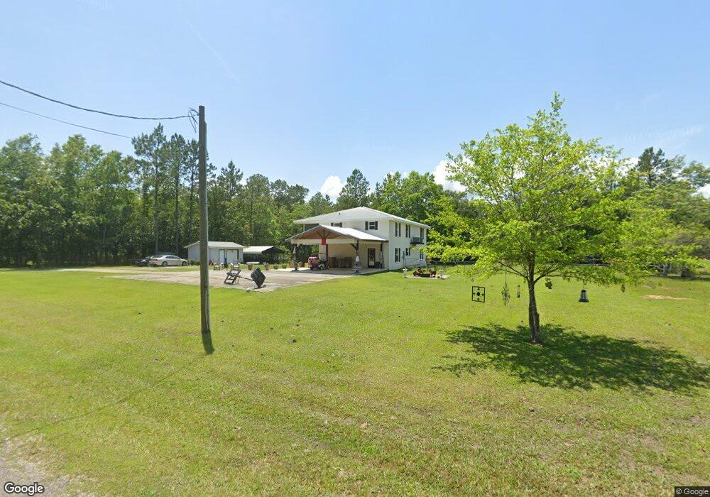
15033 Dobson Rd Biloxi, MS 39532
Estimated Value: $355,808 - $380,000
5
Beds
4
Baths
3,100
Sq Ft
$117/Sq Ft
Est. Value
About This Home
This home is located at 15033 Dobson Rd, Biloxi, MS 39532 and is currently estimated at $364,202, approximately $117 per square foot. 15033 Dobson Rd is a home located in Harrison County with nearby schools including D'Iberville Senior High School.
Ownership History
Date
Name
Owned For
Owner Type
Purchase Details
Closed on
Jan 5, 2024
Sold by
Landrum George A and Landrum Janice Underwood
Bought by
Campbell Christopher and Campbell Krysta
Current Estimated Value
Home Financials for this Owner
Home Financials are based on the most recent Mortgage that was taken out on this home.
Original Mortgage
$350,000
Outstanding Balance
$343,560
Interest Rate
7.22%
Mortgage Type
VA
Estimated Equity
$20,642
Purchase Details
Closed on
Feb 26, 2021
Sold by
Mano War Llc
Bought by
Landrum George A and Landrum Janice Underwood
Home Financials for this Owner
Home Financials are based on the most recent Mortgage that was taken out on this home.
Original Mortgage
$270,000
Interest Rate
2.7%
Mortgage Type
VA
Purchase Details
Closed on
Jul 22, 2020
Sold by
Poss Lisa M
Bought by
Man O War Llc
Create a Home Valuation Report for This Property
The Home Valuation Report is an in-depth analysis detailing your home's value as well as a comparison with similar homes in the area
Purchase History
| Date | Buyer | Sale Price | Title Company |
|---|---|---|---|
| Campbell Christopher | -- | Pilger Title | |
| Landrum George A | -- | None Available | |
| Landrum George A | -- | None Listed On Document | |
| Man O War Llc | -- | None Available |
Source: Public Records
Mortgage History
| Date | Status | Borrower | Loan Amount |
|---|---|---|---|
| Open | Campbell Christopher | $350,000 | |
| Previous Owner | Landrum George A | $270,000 |
Source: Public Records
Tax History
| Year | Tax Paid | Tax Assessment Tax Assessment Total Assessment is a certain percentage of the fair market value that is determined by local assessors to be the total taxable value of land and additions on the property. | Land | Improvement |
|---|---|---|---|---|
| 2025 | $2,214 | $14,605 | $0 | $0 |
| 2024 | $730 | $13,924 | $0 | $0 |
| 2023 | $733 | $13,924 | $0 | $0 |
| 2022 | $738 | $13,924 | $0 | $0 |
| 2021 | $2,408 | $20,886 | $0 | $0 |
| 2020 | $669 | $13,114 | $0 | $0 |
| 2019 | $652 | $12,933 | $0 | $0 |
| 2018 | $657 | $12,933 | $0 | $0 |
| 2017 | $657 | $12,933 | $0 | $0 |
| 2015 | $838 | $14,311 | $0 | $0 |
| 2014 | -- | $7,500 | $0 | $0 |
| 2013 | -- | $21,466 | $1,380 | $20,086 |
Source: Public Records
Map
Nearby Homes
- 4155 Tux River Cir
- 0 F Rd Unit 4092688
- 0 Dobson Rd Unit 4114623
- 0 Rivers Pointe Rd Unit 4114609
- 15320 Old Highway 15
- 15407 Old Highway 15
- 14086 Harley Dr
- 14087 Maddie Cir
- 0 Rivers Pointe Dr Unit 4114604
- 14085 Lamey Bridge Rd
- 14040 Seymour Dr
- 17264 Coventry Estates Blvd
- 14188 Longwood Cir
- 5530 Landing Ct
- 3419 Stephen Earl Dr
- 5046 Fairbury Way
- 0 Longwood Cir Unit 4112916
- 5113 Fairbury Way
- 3725 Victor Ln
- 14327 Viola Way
- 15033 Dobson Rd
- 4011 Tux River Dr
- LOT 27 Lot 27 Tux River Cir
- 4047 Tux River Cir
- 4047 Tux River Cir
- Lot 27 Tux River Cir
- 4012 Tux River Dr
- 4289 Tux River Cir
- 4074 Tux River Cir
- 4282 Tux River Cir
- 4282 Tux River Cir
- 0 Dobson Rd Unit 4039066
- 0 Dobson Rd Unit 3222153
- 0 Dobson Rd Unit 3265326
- 0 Dobson Rd Unit 3272217
- 0 Dobson Rd Unit 3278979
- 0 Dobson Rd Unit 3279103
- 0 Dobson Rd Unit 3279106
- 0 Dobson Rd Unit 3349841
- 0 Dobson Rd Unit 4023245
Your Personal Tour Guide
Ask me questions while you tour the home.