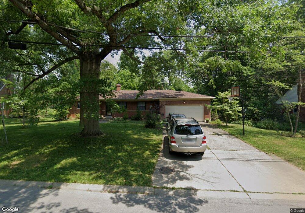
1504 Oak Knoll Dr Cincinnati, OH 45224
Estimated Value: $254,000 - $319,000
3
Beds
2
Baths
1,529
Sq Ft
$193/Sq Ft
Est. Value
About This Home
This home is located at 1504 Oak Knoll Dr, Cincinnati, OH 45224 and is currently estimated at $295,172, approximately $193 per square foot. 1504 Oak Knoll Dr is a home located in Hamilton County with nearby schools including Pleasant Hill Elementary School, Robert A. Taft Information Technology High School, and Western Hills High School.
Ownership History
Date
Name
Owned For
Owner Type
Purchase Details
Closed on
Aug 22, 2008
Sold by
Strom Joan and Buescher Robert
Bought by
Nagel Thomas H and Nagel Melinda J
Current Estimated Value
Home Financials for this Owner
Home Financials are based on the most recent Mortgage that was taken out on this home.
Original Mortgage
$186,017
Interest Rate
6.31%
Mortgage Type
FHA
Create a Home Valuation Report for This Property
The Home Valuation Report is an in-depth analysis detailing your home's value as well as a comparison with similar homes in the area
Home Values in the Area
Average Home Value in this Area
Purchase History
| Date | Buyer | Sale Price | Title Company |
|---|---|---|---|
| Nagel Thomas H | $159,000 | Attorney |
Source: Public Records
Mortgage History
| Date | Status | Borrower | Loan Amount |
|---|---|---|---|
| Open | Nagel Thomas H | $186,017 |
Source: Public Records
Tax History Compared to Growth
Tax History
| Year | Tax Paid | Tax Assessment Tax Assessment Total Assessment is a certain percentage of the fair market value that is determined by local assessors to be the total taxable value of land and additions on the property. | Land | Improvement |
|---|---|---|---|---|
| 2024 | $4,774 | $79,615 | $16,352 | $63,263 |
| 2023 | $4,881 | $79,615 | $16,352 | $63,263 |
| 2022 | $3,322 | $48,454 | $13,314 | $35,140 |
| 2021 | $3,190 | $48,454 | $13,314 | $35,140 |
| 2020 | $3,284 | $48,454 | $13,314 | $35,140 |
| 2019 | $3,149 | $42,505 | $11,680 | $30,825 |
| 2018 | $3,154 | $42,505 | $11,680 | $30,825 |
| 2017 | $2,996 | $42,505 | $11,680 | $30,825 |
| 2016 | $3,299 | $46,183 | $12,464 | $33,719 |
| 2015 | $2,976 | $46,183 | $12,464 | $33,719 |
| 2014 | $2,997 | $46,183 | $12,464 | $33,719 |
| 2013 | $3,142 | $47,611 | $12,849 | $34,762 |
Source: Public Records
Map
Nearby Homes
- 6785 Marvin Ave
- 6765 Richard Ave
- 1562 Oak Knoll Dr
- 1566 Oak Knoll Dr
- 6820 Tarawa Dr
- 6531 Hamilton Ave
- 6543 Hamilton Ave
- 1544 W Galbraith Rd
- 1544 W Galbraith Rd Unit 503
- 1621 Sundale Ave
- 7929 Cherrywood Ct
- 6521 Meis Ave
- 6712 Park Place
- 1280 Brushwood Ave
- 1453 Larrywood Ln
- 1613 de Armand Ave
- 1549 Teakwood Ave
- 1634 Birchwood Ave
- 1586 W Galbraith Rd
- 1522 Wittekind Terrace
- 1506 Oak Knoll Dr
- 6748 Tarawa Dr
- 1500 Oak Knoll Dr
- 6752 Tarawa Dr
- 1510 Oak Knoll Dr
- 1505 Oak Knoll Dr
- 1501 Oak Knoll Dr
- 6756 Tarawa Dr
- 6749 Tarawa Dr
- 1514 Oak Knoll Dr
- 6574 Baywood Ln
- 6760 Tarawa Dr
- 6779 Marvin Ave
- 6753 Tarawa Dr
- 1472 Oak Knoll Dr
- 6631 Loiswood Dr
- 1518 Oak Knoll Dr
- 6781 Marvin Ave
- 6570 Baywood Ln
- 6570 Baywood Dr