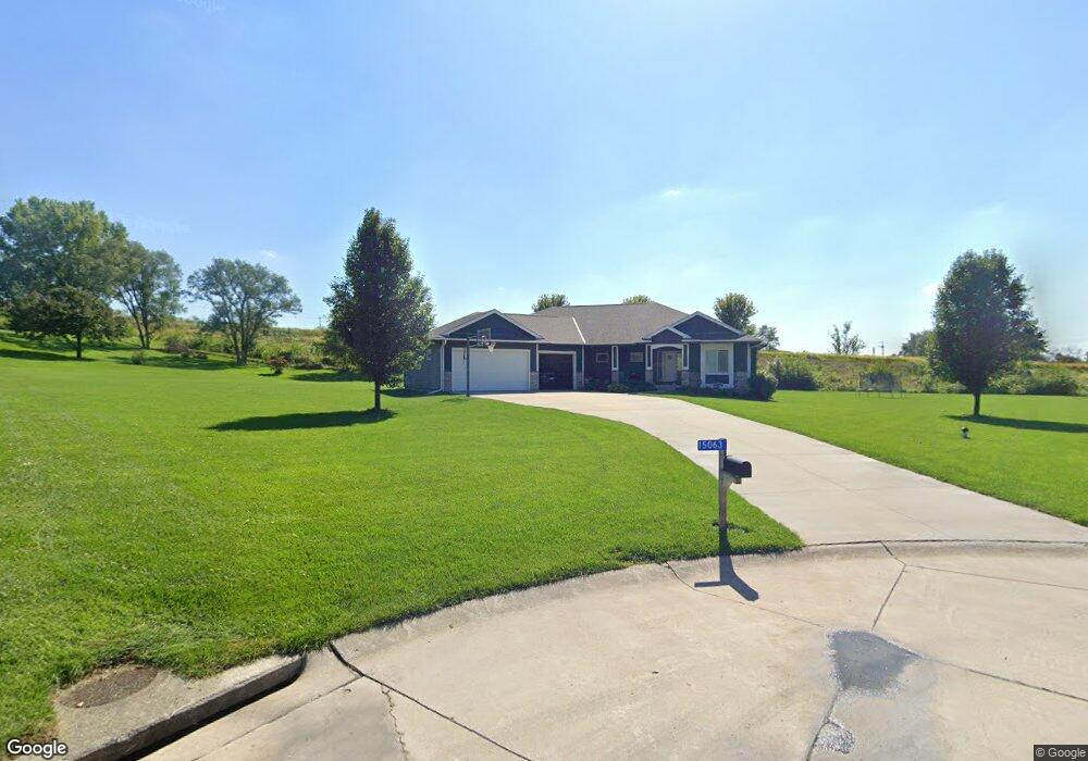
15063 Brookside Ln Council Bluffs, IA 51503
Eastern Council Bluffs NeighborhoodEstimated Value: $469,000 - $720,000
5
Beds
3
Baths
2,172
Sq Ft
$264/Sq Ft
Est. Value
About This Home
This home is located at 15063 Brookside Ln, Council Bluffs, IA 51503 and is currently estimated at $572,728, approximately $263 per square foot. 15063 Brookside Ln is a home with nearby schools including E.A. Kreft Primary School, Titan Hill Intermediate School, and Lewis Central Middle School.
Ownership History
Date
Name
Owned For
Owner Type
Purchase Details
Closed on
Jan 24, 2025
Sold by
Mings Robert J and Mings Jani S
Bought by
Blay Reece and Bradshaw Reagan
Current Estimated Value
Purchase Details
Closed on
Apr 25, 2016
Sold by
Mings Robert J and Mings Jani S
Bought by
Cooper Aaron and Cooper Tressa
Home Financials for this Owner
Home Financials are based on the most recent Mortgage that was taken out on this home.
Original Mortgage
$386,491
Interest Rate
3.71%
Mortgage Type
New Conventional
Create a Home Valuation Report for This Property
The Home Valuation Report is an in-depth analysis detailing your home's value as well as a comparison with similar homes in the area
Home Values in the Area
Average Home Value in this Area
Purchase History
| Date | Buyer | Sale Price | Title Company |
|---|---|---|---|
| Blay Reece | $149,875 | None Listed On Document | |
| Cooper Aaron | $415,000 | Attorney |
Source: Public Records
Mortgage History
| Date | Status | Borrower | Loan Amount |
|---|---|---|---|
| Previous Owner | Cooper Aaron | $386,491 |
Source: Public Records
Tax History Compared to Growth
Tax History
| Year | Tax Paid | Tax Assessment Tax Assessment Total Assessment is a certain percentage of the fair market value that is determined by local assessors to be the total taxable value of land and additions on the property. | Land | Improvement |
|---|---|---|---|---|
| 2025 | $6,046 | $611,200 | $81,800 | $529,400 |
| 2024 | $6,046 | $543,800 | $71,100 | $472,700 |
| 2023 | $5,780 | $543,800 | $71,100 | $472,700 |
| 2022 | $5,264 | $423,100 | $62,200 | $360,900 |
| 2021 | $8,087 | $423,100 | $62,200 | $360,900 |
| 2020 | $5,900 | $423,100 | $62,200 | $360,900 |
| 2019 | $6,156 | $423,100 | $62,200 | $360,900 |
| 2018 | $5,910 | $423,100 | $62,200 | $360,900 |
| 2017 | $3,414 | $237,400 | $54,800 | $182,600 |
| 2015 | $648 | $43,897 | $43,897 | $0 |
| 2014 | $654 | $43,897 | $43,897 | $0 |
Source: Public Records
Map
Nearby Homes
- 22231 Stoneybrook Dr
- 22080 Greenview Rd
- 184 Dayan Dr
- 21337 Greenview Rd
- 5021 Providence Rd
- 4820 Oneida Cir
- LOT 3 Ardmore St
- LOT 30 Ardmore St
- LOT 1 Ardmore St
- LOT 2 Ardmore St
- LOT 4 Ardmore St
- LOT 24 Ardmore St
- LOT 23 Ardmore St
- LOT 19 Ardmore St
- LOT 21 Ardmore St
- LOT 17 Ardmore St
- LOT 6 Ardmore St
- LOT 18 Ardmore St
- LOT 16 Ardmore St
- LOT 20 Ardmore St
- 15058 Brookside Ln
- 15085 Brookside Ln
- 22130 Stoneybrook Dr
- 15074 Brookside Ln
- 21669 Pebblestone Dr
- 15114 Brookside Ln
- 22202 Stoneybrook Dr
- 15141 220th St
- 22151 Stoneybrook Dr
- 15146 Brookside Ln
- 15164 Bloomfield Ln
- 22212 Pebblestone Dr
- 22249 Stoneybrook Dr
- 15195 220th St
- 15277 Bloomfield Ln
- 15206 Bloomfield Ln
- 22278 Stoneybrook Dr
- 15066 Cobblestone Ln
- 22285 Stoneybrook Dr
- 14887 Canoe Ln