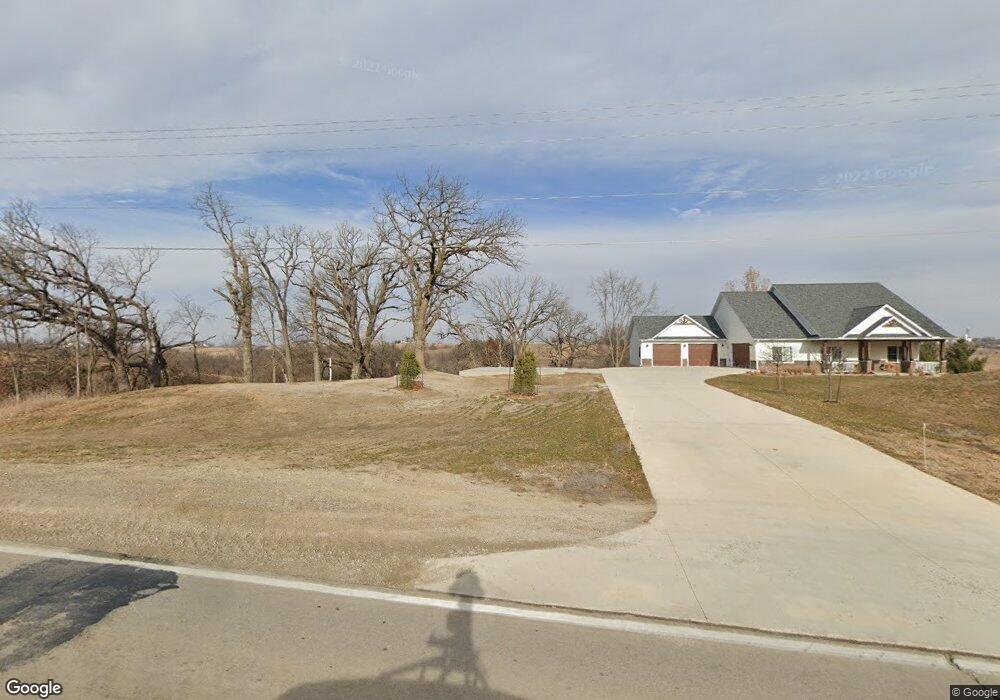
1508 Highway F36 W Newton, IA 50208
Estimated Value: $512,000 - $746,074
4
Beds
3
Baths
2,678
Sq Ft
$229/Sq Ft
Est. Value
About This Home
This home is located at 1508 Highway F36 W, Newton, IA 50208 and is currently estimated at $613,025, approximately $228 per square foot. 1508 Highway F36 W is a home located in Jasper County with nearby schools including Thomas Jefferson Elementary School, Woodrow Wilson Elementary School, and Berg Middle School.
Ownership History
Date
Name
Owned For
Owner Type
Purchase Details
Closed on
Apr 3, 2019
Sold by
Lloyd Larry L and Lloyd Ruth L
Bought by
Lloyd Jeffrey S and Lloyd Beverly A
Current Estimated Value
Purchase Details
Closed on
Mar 22, 2019
Sold by
Lloyd Jeffrey S and Lloyd Beverly A
Bought by
Mccuen John R and Mccuen Laurie A
Purchase Details
Closed on
Sep 30, 2008
Sold by
Lloyd Larry L and Lloyd Ruth L
Bought by
Lloyd Jeffrey S and Lloyd Beverly A
Create a Home Valuation Report for This Property
The Home Valuation Report is an in-depth analysis detailing your home's value as well as a comparison with similar homes in the area
Home Values in the Area
Average Home Value in this Area
Purchase History
| Date | Buyer | Sale Price | Title Company |
|---|---|---|---|
| Lloyd Jeffrey S | $60,000 | -- | |
| Mccuen John R | $60,000 | -- | |
| Lloyd Jeffrey S | $60,000 | None Available |
Source: Public Records
Tax History Compared to Growth
Tax History
| Year | Tax Paid | Tax Assessment Tax Assessment Total Assessment is a certain percentage of the fair market value that is determined by local assessors to be the total taxable value of land and additions on the property. | Land | Improvement |
|---|---|---|---|---|
| 2025 | $8,738 | $856,970 | $76,000 | $780,970 |
| 2024 | $8,738 | $681,570 | $51,890 | $629,680 |
| 2023 | $8,464 | $681,570 | $51,890 | $629,680 |
| 2022 | $7,296 | $545,490 | $51,890 | $493,600 |
| 2021 | $7,020 | $501,960 | $51,890 | $450,070 |
| 2020 | $7,020 | $458,870 | $49,970 | $408,900 |
| 2019 | $842 | $50,430 | $0 | $0 |
| 2018 | $842 | $50,430 | $0 | $0 |
| 2017 | $842 | $50,430 | $0 | $0 |
| 2016 | $842 | $50,430 | $0 | $0 |
| 2015 | $822 | $50,430 | $0 | $0 |
| 2014 | $806 | $50,430 | $0 | $0 |
Source: Public Records
Map
Nearby Homes
- 1650 W 28th St N
- 1005 W 8th St N
- 1525 1st St N
- 1401 1st St N
- 1420 1st St N
- 549 W 10th St N
- 3735 W 3rd St N
- 316 N 9th Ave W
- 831 1st St N
- 304 W 11th St N
- 124 Emerson Hough Dr
- 1100 1st Ave W
- 1000 1st Ave W
- 506 N 8th Ave E
- 6911-10 Highway F 48 W
- 817 E 6th St N
- 1221 Monroe Dr
- 701 E 5th St N
- 210 W 13th St S
- 918 E 6th St N
- 1419 N 23rd Ave W
- 1501 N 23rd Ave W
- 1192 N 23rd Ave W
- 1517 N 23rd Ave W
- 1401 N 23rd Ave W Unit C
- 1401 N 23rd Ave W
- 1401 N 23rd Ave W Unit B
- 1401 N 23rd Ave W
- 1607 N 23rd Ave W
- 1705 N 23rd Ave W
- 440 N 23rd Ave W
- 0 N 23rd Ave W Unit 594034
- 0 N 23rd Ave W
- 1721 N 23rd Ave W
- 2377 W 12th St N
- 2493 W 12th St N
- 1878 Highway F36 W
- 1805 N 23rd Ave W Unit B
- 1805 N 23rd Ave W
- 1805 N 23rd Ave W