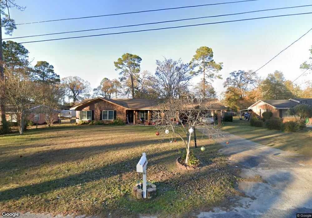
1509 Botts Dr Bainbridge, GA 39819
Estimated Value: $163,000 - $197,000
3
Beds
2
Baths
1,440
Sq Ft
$120/Sq Ft
Est. Value
About This Home
This home is located at 1509 Botts Dr, Bainbridge, GA 39819 and is currently estimated at $172,953, approximately $120 per square foot. 1509 Botts Dr is a home located in Decatur County with nearby schools including Bainbridge High School and Grace Christian Academy.
Ownership History
Date
Name
Owned For
Owner Type
Purchase Details
Closed on
Jul 12, 2012
Sold by
Federal National Mortgage Association
Bought by
Escobar Michael
Current Estimated Value
Home Financials for this Owner
Home Financials are based on the most recent Mortgage that was taken out on this home.
Original Mortgage
$50,000
Interest Rate
3.72%
Mortgage Type
New Conventional
Purchase Details
Closed on
Jan 3, 2012
Sold by
Jpmorgan Chase Bank Nation
Bought by
Federal National Mtg Associati
Create a Home Valuation Report for This Property
The Home Valuation Report is an in-depth analysis detailing your home's value as well as a comparison with similar homes in the area
Purchase History
| Date | Buyer | Sale Price | Title Company |
|---|---|---|---|
| Escobar Michael | -- | -- | |
| Federal National Mtg Associati | $105,365 | -- | |
| Jpmorgan Chase Bank National A | $105,365 | -- |
Source: Public Records
Mortgage History
| Date | Status | Borrower | Loan Amount |
|---|---|---|---|
| Closed | Escobar Michael | $50,000 |
Source: Public Records
Tax History
| Year | Tax Paid | Tax Assessment Tax Assessment Total Assessment is a certain percentage of the fair market value that is determined by local assessors to be the total taxable value of land and additions on the property. | Land | Improvement |
|---|---|---|---|---|
| 2024 | $1,338 | $44,113 | $3,574 | $40,539 |
| 2023 | $848 | $44,113 | $3,574 | $40,539 |
| 2022 | $1,306 | $44,113 | $3,574 | $40,539 |
| 2021 | $1,136 | $37,634 | $3,574 | $34,060 |
| 2020 | $1,023 | $32,354 | $3,574 | $28,780 |
| 2019 | $1,010 | $30,842 | $3,574 | $27,268 |
| 2018 | $999 | $30,842 | $3,574 | $27,268 |
| 2017 | $1,018 | $29,122 | $3,552 | $25,570 |
| 2016 | $958 | $29,122 | $3,552 | $25,570 |
| 2015 | $986 | $29,122 | $3,552 | $25,570 |
| 2014 | $915 | $29,122 | $3,552 | $25,570 |
| 2013 | -- | $29,121 | $3,552 | $25,569 |
Source: Public Records
Map
Nearby Homes
- 1511 Woodland Dr
- 1504 Woodland Dr
- 1406 Botts Dr
- 1604 Twin Lakes Dr
- 1602 Twin Lakes Dr
- 1600 Dogwood Dr
- 1103 Stewart Ave
- 703 S Boulevard Dr
- 1715 Douglas Dr
- 1106 E Pine St
- 1512 Douglas Dr
- 401 S Collier St
- 502 Chason St
- 502 Chason St
- 809 S Lamar St
- 1702 Culbreth St
- 1307 E Broughton St
- 515 S Spruce St
- 600 S Lamar St
- 1203 E Broughton St
- 1507 Botts Dr
- 1511 Botts Dr
- 1505 Botts Dr
- 1513 Botts Dr
- 1513 Botts St
- 1508 Botts Dr
- 1508 E College St
- 1506 Botts Dr
- 1510 Botts Dr
- 1510 E College St
- 1506 E College St
- 1504 E College St
- 1504 Botts Dr
- 1503 Botts Dr
- 1512 E College St
- 1512 Botts Dr
- 1502 Botts Dr
- 1502 E College St
- 1501 Botts Dr
- 955 Gordon Ave