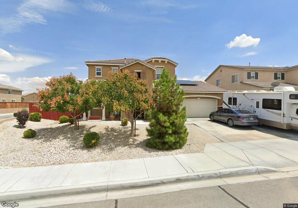
15095 Brucite Rd Victorville, CA 92394
Mesa Linda NeighborhoodEstimated Value: $473,970 - $520,000
4
Beds
3
Baths
2,544
Sq Ft
$194/Sq Ft
Est. Value
About This Home
This home is located at 15095 Brucite Rd, Victorville, CA 92394 and is currently estimated at $493,243, approximately $193 per square foot. 15095 Brucite Rd is a home with nearby schools including West Creek Elementary School, Adelanto High School, and Zion Lutheran School And Preschool.
Ownership History
Date
Name
Owned For
Owner Type
Purchase Details
Closed on
Oct 24, 2014
Sold by
Victorville 115 Lots Lp
Bought by
Caro Jesus Roberto and Caro Indra
Current Estimated Value
Home Financials for this Owner
Home Financials are based on the most recent Mortgage that was taken out on this home.
Original Mortgage
$252,595
Outstanding Balance
$194,077
Interest Rate
4.16%
Mortgage Type
VA
Estimated Equity
$299,166
Create a Home Valuation Report for This Property
The Home Valuation Report is an in-depth analysis detailing your home's value as well as a comparison with similar homes in the area
Home Values in the Area
Average Home Value in this Area
Purchase History
| Date | Buyer | Sale Price | Title Company |
|---|---|---|---|
| Caro Jesus Roberto | $253,000 | First American Title |
Source: Public Records
Mortgage History
| Date | Status | Borrower | Loan Amount |
|---|---|---|---|
| Open | Caro Jesus Roberto | $252,595 |
Source: Public Records
Tax History Compared to Growth
Tax History
| Year | Tax Paid | Tax Assessment Tax Assessment Total Assessment is a certain percentage of the fair market value that is determined by local assessors to be the total taxable value of land and additions on the property. | Land | Improvement |
|---|---|---|---|---|
| 2025 | $3,509 | $303,581 | $30,047 | $273,534 |
| 2024 | $3,509 | $297,629 | $29,458 | $268,171 |
| 2023 | $3,548 | $291,793 | $28,880 | $262,913 |
| 2022 | $3,601 | $286,072 | $28,314 | $257,758 |
| 2021 | $3,685 | $280,463 | $27,759 | $252,704 |
| 2020 | $3,675 | $277,587 | $27,474 | $250,113 |
| 2019 | $3,674 | $272,144 | $26,935 | $245,209 |
| 2018 | $3,715 | $266,808 | $26,407 | $240,401 |
| 2017 | $3,679 | $261,576 | $25,889 | $235,687 |
| 2016 | $5,184 | $256,447 | $25,381 | $231,066 |
| 2015 | $5,031 | $252,595 | $25,000 | $227,595 |
| 2014 | $4,536 | $193,404 | $8,404 | $185,000 |
Source: Public Records
Map
Nearby Homes
- 13551 Western Meadows Ln
- 15184 Brucite Rd
- 13651 Gold Stone Place
- 14964 Butler Peak Ct
- 15203 Zircon Dr
- Residence 1310 Plan at Dawson Pointe at West Creek
- Residence 1583 Plan at Dawson Pointe at West Creek
- Residence 2057 Plan at Dawson Pointe at West Creek
- Residence 2260 Plan at Dawson Pointe at West Creek
- Residence 1816 Plan at Dawson Pointe at West Creek
- 14991 Mandalay Ln
- 15255 Sunray Ct
- 15134 Paseo Verde Place
- 15121 Sorrel Rd
- 15426 Tomahawk St
- 15432 Tomahawk St
- 15165 Bluffside Ln
- 15425 Tomahawk St
- 14766 Shetland Ct
- 15438 Tomahawk St
- 15083 Brucite Rd
- 13533 Quail Cove Place
- 15097 Brucite Rd
- 15071 Brucite Rd
- 13545 Quail Cove Place
- 15092 Brucite Rd
- 15098 Ridgebriar Ln
- 13538 Glen Rose Way
- 15105 Brucite Rd
- 13498 Quail Cove Place
- 13546 Glen Rose Way
- 13557 Quail Cove Place
- 15068 Brucite Rd
- 13489 Quail Cove Place
- 15113 Brucite Rd
- 13490 Quail Cove Place
- 15101 Ridgebriar Ln
- 15114 Ridgebriar Ln
- 15056 Brucite Rd