Estimated Value: $202,000 - $225,000
4
Beds
2
Baths
1,210
Sq Ft
$173/Sq Ft
Est. Value
About This Home
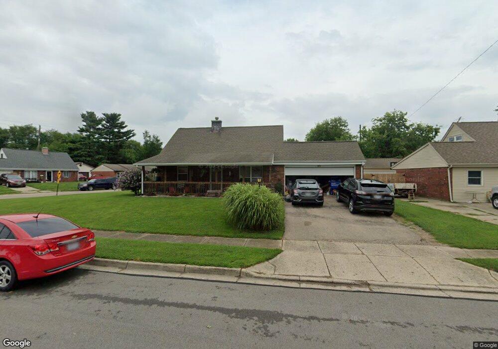
This home is located at 151 Montana Dr, Xenia, OH 45385 and is currently estimated at $209,152, approximately $172 per square foot. 151 Montana Dr is a home located in Greene County with nearby schools including Xenia High School and Summit Academy Community School for Alternative Learners - Xenia.
Ownership History
Date
Name
Owned For
Owner Type
Purchase Details
Closed on
Mar 24, 2014
Sold by
Rasnic Christopher L
Bought by
Basnic Kelly S
Current Estimated Value
Purchase Details
Closed on
Mar 30, 2001
Sold by
Mcgarvey John J and Mcgarvey Rebecca J
Bought by
Rasnic Christopher L and Rasnic Kelly S
Home Financials for this Owner
Home Financials are based on the most recent Mortgage that was taken out on this home.
Original Mortgage
$93,163
Outstanding Balance
$34,625
Interest Rate
7.13%
Mortgage Type
FHA
Estimated Equity
$174,527
Purchase Details
Closed on
May 11, 1998
Sold by
Nagin Sheth
Bought by
Mcgarvey John J and Mcgarvey Rebecca J
Home Financials for this Owner
Home Financials are based on the most recent Mortgage that was taken out on this home.
Original Mortgage
$62,100
Interest Rate
9.14%
Create a Home Valuation Report for This Property
The Home Valuation Report is an in-depth analysis detailing your home's value as well as a comparison with similar homes in the area
Home Values in the Area
Average Home Value in this Area
Purchase History
| Date | Buyer | Sale Price | Title Company |
|---|---|---|---|
| Basnic Kelly S | -- | None Available | |
| Rasnic Christopher L | $93,900 | -- | |
| Mcgarvey John J | $69,000 | -- |
Source: Public Records
Mortgage History
| Date | Status | Borrower | Loan Amount |
|---|---|---|---|
| Open | Rasnic Christopher L | $93,163 | |
| Closed | Mcgarvey John J | $62,100 |
Source: Public Records
Tax History Compared to Growth
Tax History
| Year | Tax Paid | Tax Assessment Tax Assessment Total Assessment is a certain percentage of the fair market value that is determined by local assessors to be the total taxable value of land and additions on the property. | Land | Improvement |
|---|---|---|---|---|
| 2024 | $2,329 | $54,430 | $12,540 | $41,890 |
| 2023 | $2,329 | $54,430 | $12,540 | $41,890 |
| 2022 | $1,938 | $38,640 | $7,380 | $31,260 |
| 2021 | $1,965 | $38,640 | $7,380 | $31,260 |
| 2020 | $1,882 | $38,640 | $7,380 | $31,260 |
| 2019 | $1,699 | $32,840 | $7,220 | $25,620 |
| 2018 | $1,706 | $32,840 | $7,220 | $25,620 |
| 2017 | $1,575 | $32,840 | $7,220 | $25,620 |
| 2016 | $1,575 | $29,760 | $7,220 | $22,540 |
| 2015 | $1,580 | $29,760 | $7,220 | $22,540 |
| 2014 | $1,471 | $29,760 | $7,220 | $22,540 |
Source: Public Records
Map
Nearby Homes
- 2758 Wyoming Dr
- 219 Kansas Dr
- 414 Whisper Ln
- 1568 Cheyenne Dr
- 1653 Seneca Dr
- 2142 Michigan Dr
- 2545 Harmony Dr
- 1618 Navajo Dr
- 121 S Progress Dr
- 1769 Gayhart Dr
- 1829 Gayhart Dr
- 2257 Maryland Dr
- 1778 Arapaho Dr
- 1144 Rockwell Dr
- 1908 Whitt St
- 1107 Arkansas Dr
- 1866 Roxbury Dr
- 1255 Colorado Dr
- 2345 Tennessee Dr
- 1342 Kylemore Dr
- 161 Montana Dr
- 2642 Wyoming Dr
- 179 Montana Dr
- 2603 Wyoming Dr
- 2615 Wyoming Dr
- 2591 Wyoming Dr
- 2576 Wyoming Dr
- 160 Montana Dr
- 2682 Wyoming Dr
- 2627 Wyoming Dr
- 2579 Wyoming Dr
- 174 Montana Dr
- 193 Montana Dr
- 2696 Wyoming Dr
- 2567 Wyoming Dr
- 188 Montana Dr
- 2639 Wyoming Dr
- 207 Montana Dr
- 161 Oregon Dr
- 179 Oregon Dr