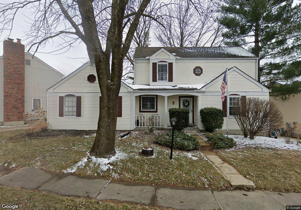
151 Pheasant Point Blvd O Fallon, MO 63368
Estimated Value: $284,810 - $327,000
2
Beds
2
Baths
1,472
Sq Ft
$205/Sq Ft
Est. Value
About This Home
This home is located at 151 Pheasant Point Blvd, O Fallon, MO 63368 and is currently estimated at $302,203, approximately $205 per square foot. 151 Pheasant Point Blvd is a home located in St. Charles County with nearby schools including Pheasant Point Elementary School, Fort Zumwalt West Middle School, and Fort Zumwalt West High School.
Ownership History
Date
Name
Owned For
Owner Type
Purchase Details
Closed on
Nov 8, 2006
Sold by
Leapley Bradley D
Bought by
Ochsner Christy
Current Estimated Value
Home Financials for this Owner
Home Financials are based on the most recent Mortgage that was taken out on this home.
Original Mortgage
$157,000
Outstanding Balance
$93,231
Interest Rate
6.28%
Mortgage Type
Purchase Money Mortgage
Estimated Equity
$208,972
Purchase Details
Closed on
Jan 7, 2003
Sold by
Leapley Dawn R
Bought by
Leapley Bradley D
Create a Home Valuation Report for This Property
The Home Valuation Report is an in-depth analysis detailing your home's value as well as a comparison with similar homes in the area
Home Values in the Area
Average Home Value in this Area
Purchase History
| Date | Buyer | Sale Price | Title Company |
|---|---|---|---|
| Ochsner Christy | $157,000 | Ort | |
| Leapley Bradley D | -- | None Available |
Source: Public Records
Mortgage History
| Date | Status | Borrower | Loan Amount |
|---|---|---|---|
| Open | Ochsner Christy | $157,000 |
Source: Public Records
Tax History
| Year | Tax Paid | Tax Assessment Tax Assessment Total Assessment is a certain percentage of the fair market value that is determined by local assessors to be the total taxable value of land and additions on the property. | Land | Improvement |
|---|---|---|---|---|
| 2025 | $3,086 | $48,474 | -- | -- |
| 2023 | $3,087 | $46,514 | $0 | $0 |
| 2022 | $2,653 | $37,137 | $0 | $0 |
| 2021 | $2,656 | $37,137 | $0 | $0 |
| 2020 | $2,565 | $34,780 | $0 | $0 |
| 2019 | $2,570 | $34,780 | $0 | $0 |
| 2018 | $2,303 | $29,716 | $0 | $0 |
| 2017 | $2,268 | $29,716 | $0 | $0 |
| 2016 | $2,002 | $26,128 | $0 | $0 |
| 2015 | $1,862 | $26,128 | $0 | $0 |
| 2014 | $1,807 | $24,951 | $0 | $0 |
Source: Public Records
Map
Nearby Homes
- 178 Christina Marie Dr
- 2136 Farnsworth Dr Unit D
- 2614 Samuel Dr Unit 711C
- 7101 Curtis Dr Unit 795B
- 67 Simeon Ct
- 611 Bennington Dr
- 26 Dalton Valley Dr
- 249 Dardenne Farms Dr
- 7139 Basswood Dr
- 2726 Brook Meadow Ln
- 3 Royallbend Ct
- 288 Alexandria Dr
- 7053 Black Horse Dr
- 10 Muir Trail Ct
- 661 Clifton Hill Dr
- 6945 Clayborne Dr
- 7409 Heathermoor Ln
- 3 Dragonstone Ct
- 9007 Camino Trail
- 7 Dragonstone Ct
- 161 Pheasant Point Blvd
- 141 Pheasant Point Blvd
- 148 Lamplighter Way
- 171 Pheasant Point Blvd
- 150 Lamplighter Way
- 131 Pheasant Point Blvd
- 144 Lamplighter Way
- 143 Lamplighter Way
- 150 Pheasant Point Blvd
- 140 Pheasant Point Blvd
- 149 Lamplighter Way
- 141 Lamplighter Way
- 121 Pheasant Point Blvd
- 142 Lamplighter Way
- 130 Pheasant Point Blvd
- 174 Pheasant Point Blvd
- 172 Pheasant Point Blvd
- 170 Pheasant Point Blvd
- 20 Lamplighter Ln
- 178 Pheasant Point Blvd
Your Personal Tour Guide
Ask me questions while you tour the home.