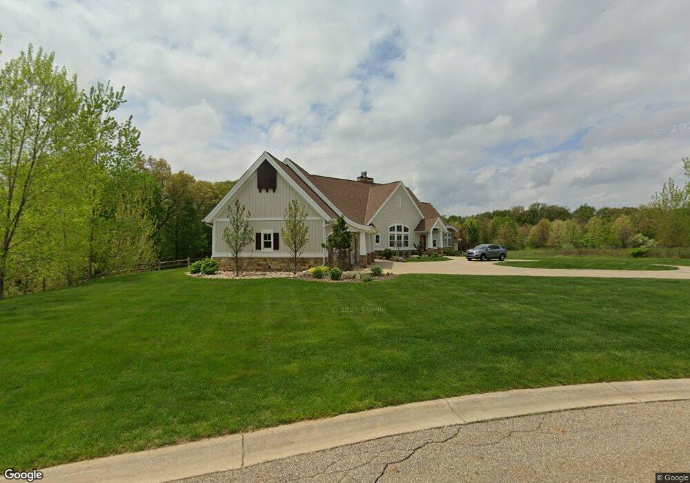
151 Stonegate Dr Battle Creek, MI 49015
Rural Southwest Battle Creek NeighborhoodEstimated Value: $522,000 - $632,920
3
Beds
4
Baths
2,548
Sq Ft
$225/Sq Ft
Est. Value
About This Home
This home is located at 151 Stonegate Dr, Battle Creek, MI 49015 and is currently estimated at $573,480, approximately $225 per square foot. 151 Stonegate Dr is a home located in Calhoun County with nearby schools including Lakeview Middle School, Lakeview High School, and Arbor Academy.
Ownership History
Date
Name
Owned For
Owner Type
Purchase Details
Closed on
Sep 2, 2008
Sold by
Stone Jug Properties Llc
Bought by
Living Trust Of Joseph N & Patricia L Ne
Current Estimated Value
Home Financials for this Owner
Home Financials are based on the most recent Mortgage that was taken out on this home.
Original Mortgage
$700,000
Outstanding Balance
$436,369
Interest Rate
5.25%
Mortgage Type
Unknown
Estimated Equity
$137,111
Create a Home Valuation Report for This Property
The Home Valuation Report is an in-depth analysis detailing your home's value as well as a comparison with similar homes in the area
Home Values in the Area
Average Home Value in this Area
Purchase History
| Date | Buyer | Sale Price | Title Company |
|---|---|---|---|
| Living Trust Of Joseph N & Patricia L Ne | -- | Chicago Title |
Source: Public Records
Mortgage History
| Date | Status | Borrower | Loan Amount |
|---|---|---|---|
| Open | Living Trust Of Joseph N & Patricia L Ne | $700,000 |
Source: Public Records
Tax History Compared to Growth
Tax History
| Year | Tax Paid | Tax Assessment Tax Assessment Total Assessment is a certain percentage of the fair market value that is determined by local assessors to be the total taxable value of land and additions on the property. | Land | Improvement |
|---|---|---|---|---|
| 2025 | -- | $295,500 | $0 | $0 |
| 2024 | $8,289 | $271,952 | $0 | $0 |
| 2023 | $9,437 | $282,124 | $0 | $0 |
| 2022 | $7,486 | $252,923 | $0 | $0 |
| 2021 | $9,191 | $252,426 | $0 | $0 |
| 2020 | $8,647 | $245,027 | $0 | $0 |
| 2019 | $8,611 | $241,857 | $0 | $0 |
| 2018 | $8,611 | $201,011 | $32,067 | $168,944 |
| 2017 | $8,350 | $214,266 | $0 | $0 |
| 2016 | $8,335 | $203,195 | $0 | $0 |
| 2015 | $8,067 | $176,150 | $16,519 | $159,631 |
| 2014 | $8,067 | $180,350 | $16,519 | $163,831 |
Source: Public Records
Map
Nearby Homes
- 156 Stonegate Ct
- 155 Stonegate Ct
- 162 Stonegate Ct
- 176 Stonegate Ct
- 170 Stonegate Ct
- 163 Stonegate Ct
- 124 Stonegate Dr
- 119 Stonegate Dr
- 106 Stonegate Dr
- 101 Stonegate Dr
- 100 Stonegate Dr
- 15000 Stone Jug Rd
- 411 Coventry Rd
- 413 Coventry Rd
- 2154 Gethings Rd
- Lot#7 Ridgeview Dr
- 209 Ridgeview
- 309 Waldon Dr
- 305 Waldon Dr
- 303 Waldon Dr
- 154 Stonegate Dr
- 143 Stonegate Dr
- 148 Stonegate Dr
- 155 Stonegate Ct
- 150 Stonegate Ct
- 142 Stonegate Dr
- 131 Stonegate Dr
- 159 Stonegate Ct
- 136 Stonegate Dr
- 150 Stonegate Dr
- 125 Stonegate Dr
- 14763 Stone Jug Rd
- 113 Stonegate Dr
- 112 Stonegate Dr
- 107 Stonegate Dr
- 4045 W Columbia Ave
- 4045 W Columbia Ave Unit 1
- 14811 Stone Jug Rd
- 15001 Stone Jug Rd
- 4051 Columbia Ave W Unit Total