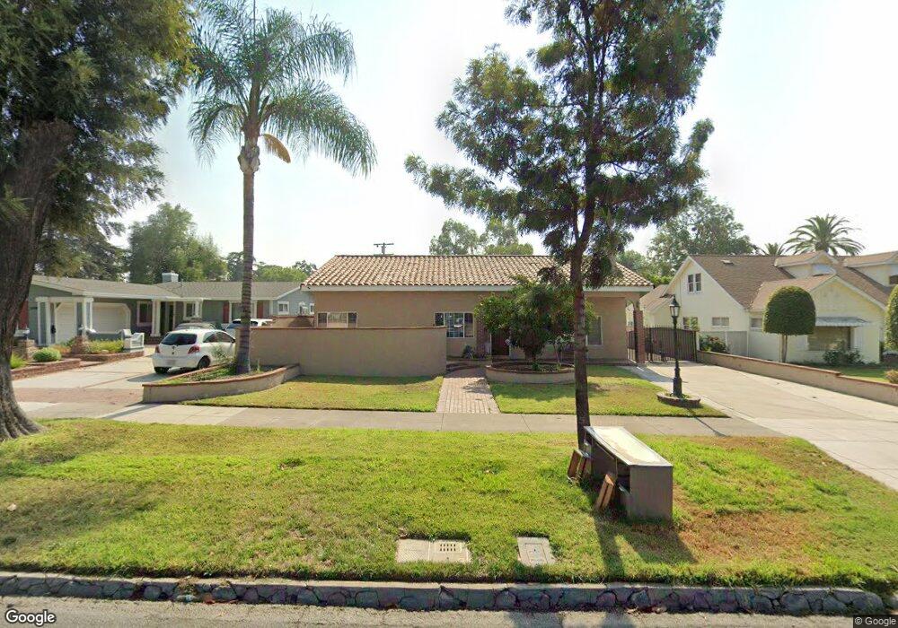
1510 N Euclid Ave Ontario, CA 91762
Downtown Ontario NeighborhoodEstimated Value: $864,000 - $939,000
--
Bed
4
Baths
2,511
Sq Ft
$364/Sq Ft
Est. Value
About This Home
This home is located at 1510 N Euclid Ave, Ontario, CA 91762 and is currently estimated at $913,000, approximately $363 per square foot. 1510 N Euclid Ave is a home located in San Bernardino County with nearby schools including Edison Elementary School, Vina Danks Middle, and Chaffey High School.
Ownership History
Date
Name
Owned For
Owner Type
Purchase Details
Closed on
Jan 9, 2025
Sold by
Moreira Pedro W
Bought by
Pw Moreira Trust and Moreira
Current Estimated Value
Purchase Details
Closed on
Mar 31, 2000
Sold by
Loos Carl G
Bought by
Moreira Pedro W and Moreira Mercedes
Home Financials for this Owner
Home Financials are based on the most recent Mortgage that was taken out on this home.
Original Mortgage
$174,540
Interest Rate
8.18%
Mortgage Type
FHA
Create a Home Valuation Report for This Property
The Home Valuation Report is an in-depth analysis detailing your home's value as well as a comparison with similar homes in the area
Home Values in the Area
Average Home Value in this Area
Purchase History
| Date | Buyer | Sale Price | Title Company |
|---|---|---|---|
| Pw Moreira Trust | -- | None Listed On Document | |
| Moreira Pedro W | $176,000 | Orange Coast Title |
Source: Public Records
Mortgage History
| Date | Status | Borrower | Loan Amount |
|---|---|---|---|
| Previous Owner | Moreira Pedro W | $174,540 |
Source: Public Records
Tax History Compared to Growth
Tax History
| Year | Tax Paid | Tax Assessment Tax Assessment Total Assessment is a certain percentage of the fair market value that is determined by local assessors to be the total taxable value of land and additions on the property. | Land | Improvement |
|---|---|---|---|---|
| 2025 | $2,848 | $270,511 | $76,850 | $193,661 |
| 2024 | $2,848 | $265,207 | $75,343 | $189,864 |
| 2023 | $2,767 | $260,007 | $73,866 | $186,141 |
| 2022 | $2,729 | $254,909 | $72,418 | $182,491 |
| 2021 | $2,710 | $249,911 | $70,998 | $178,913 |
| 2020 | $2,662 | $247,348 | $70,270 | $177,078 |
| 2019 | $2,638 | $242,498 | $68,892 | $173,606 |
| 2018 | $2,600 | $237,743 | $67,541 | $170,202 |
| 2017 | $2,505 | $233,082 | $66,217 | $166,865 |
| 2016 | $2,405 | $228,512 | $64,919 | $163,593 |
| 2015 | $2,388 | $225,080 | $63,944 | $161,136 |
| 2014 | $2,312 | $220,671 | $62,691 | $157,980 |
Source: Public Records
Map
Nearby Homes
- 340 W Caroline Ct
- 355 S 3rd Ave
- 345 S Euclid Ave
- 424 W 7th St
- 263 S 3rd Ave
- 173 Elizabeth Ln
- 224 E Princeton St
- 636 Highland Ct
- 173 W 8th St
- 1557 N Beverly Ct
- 278 Verdugo Way
- 181 Dorsett Ave
- 703 W 7th St
- 529 E Harvard Place
- 167 Sultana Ave
- 144 Dorsett Ave
- 115 E Rosewood Ct
- 147 Royal Way
- 384 Ruby Red Ln
- 144 Royal Way
- 1510 N Euclid Ave
- 1518 N Euclid Ave
- 1506 N Euclid Ave
- 1524 N Euclid Ave
- 121 E 6th St
- 120 E Deodar St
- 1458 N Euclid Ave
- 128 E Deodar St
- 131 E 6th St
- 1540 N Euclid Ave
- 1452 N Euclid Ave
- 118 E 6th St
- 202 E Deodar St
- 124 E 6th St
- 115 E Deodar St
- 106 W 6th St Unit A
- 106 W 6th St
- 1446 N Euclid Ave
- 1544 N Euclid Ave
- 205 E 6th St