
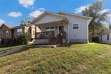

15103 E Truman Rd Independence, MO 64050
Benton NeighborhoodEstimated payment $1,073/month
Highlights
- Deck
- No HOA
- Forced Air Heating and Cooling System
- Ranch Style House
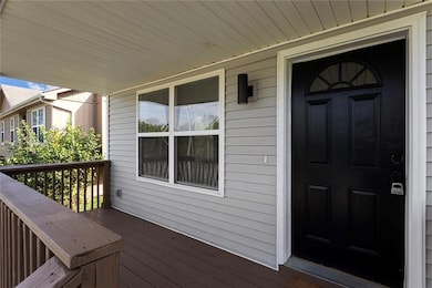
- Covered Patio or Porch
- Paved or Partially Paved Lot
About This Home
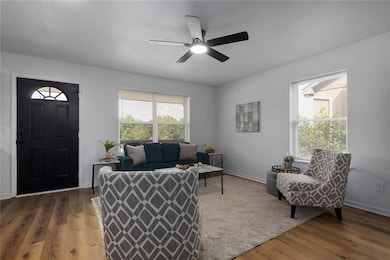
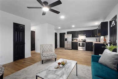
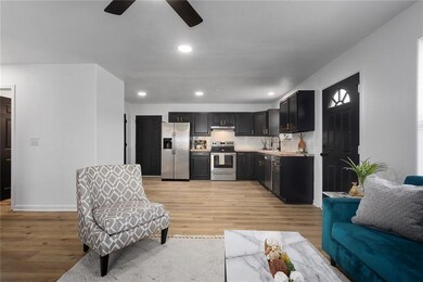
Step into this beautiful, rehabbed home, where modern living meets comfort and charm. Enjoy your morning coffee on the inviting covered front porch, then head inside to a bright, open floorplan filled with natural light. The spacious family room flows seamlessly into a sleek, modern kitchen featuring stainless steel appliances. Throughout the home, you’ll find updated plumbing and stylish light fixtures that add a fresh, contemporary touch. Outside, the nicely treed yard offers shade and serenity, along with a handy shed for storing all your lawn care essentials. This move-in ready gem is a must-see!
Listing Agent
ReeceNichols - Lees Summit Brokerage Phone: 816-838-6302 License #WP-7291580 Listed on: 10/02/2025

Home Details
Home Type
- Single Family
Est. Annual Taxes
- $1,255
Year Built
- Built in 2006
Lot Details
- 6,271 Sq Ft Lot
- Lot Dimensions are 51x123x51x123
- Paved or Partially Paved Lot
Parking
- Off-Street Parking
Home Design
- 1,092 Sq Ft Home
- Ranch Style House
- Traditional Architecture
- Slab Foundation
- Composition Roof
- Vinyl Siding
Bedrooms and Bathrooms
- 3 Bedrooms
- 2 Full Bathrooms
Outdoor Features
- Deck
- Covered Patio or Porch
Utilities
- Forced Air Heating and Cooling System
Community Details
- No Home Owners Association
- Smith Wm Sub Subdivision
Listing and Financial Details
- Exclusions: see disclosure
- Assessor Parcel Number 26-130-03-03-00-0-00-000
- $0 special tax assessment
Map
Home Values in the Area
Average Home Value in this Area
Tax History
| Year | Tax Paid | Tax Assessment Tax Assessment Total Assessment is a certain percentage of the fair market value that is determined by local assessors to be the total taxable value of land and additions on the property. | Land | Improvement |
|---|---|---|---|---|
| 2025 | $1,255 | $20,824 | $3,122 | $17,702 |
| 2024 | $1,255 | $18,109 | $984 | $17,125 |
| 2023 | $1,226 | $18,109 | $984 | $17,125 |
| 2022 | $1,319 | $17,860 | $2,852 | $15,008 |
| 2021 | $1,319 | $17,860 | $2,852 | $15,008 |
| 2020 | $1,295 | $17,047 | $2,852 | $14,195 |
| 2019 | $1,275 | $17,047 | $2,852 | $14,195 |
| 2018 | $1,162 | $14,836 | $2,482 | $12,354 |
| 2017 | $1,033 | $14,836 | $2,482 | $12,354 |
| 2016 | $1,033 | $13,063 | $1,761 | $11,302 |
| 2014 | $981 | $12,683 | $1,710 | $10,973 |
Property History
| Date | Event | Price | List to Sale | Price per Sq Ft |
|---|---|---|---|---|
| 12/05/2025 12/05/25 | Price Changed | $184,500 | -2.9% | $169 / Sq Ft |
| 10/21/2025 10/21/25 | Price Changed | $190,000 | -5.0% | $174 / Sq Ft |
| 10/02/2025 10/02/25 | For Sale | $200,000 | -- | $183 / Sq Ft |
Purchase History
| Date | Type | Sale Price | Title Company |
|---|---|---|---|
| Warranty Deed | $52,000 | Alpha Title | |
| Corporate Deed | -- | Old Republic Title Company | |
| Special Warranty Deed | $296 | -- |
Mortgage History
| Date | Status | Loan Amount | Loan Type |
|---|---|---|---|
| Previous Owner | $65,000 | Seller Take Back |
Source: Heartland MLS
MLS Number: 2578698
APN: 26-130-03-03-00-0-00-000
Disclaimer: Certain information contained herein is derived from information provided by parties other than Homes.com. All information provided is deemed reliable, but is not guaranteed to be accurate and should be independently verified.
![]() Based on information submitted to the MLS GRID as of [see last changed date above]. All data is obtained from various sources and may not have been verified by broker or MLS GRID. Supplied Open House Information is subject to change without notice. All information should be independently reviewed and verified for accuracy. Properties may or may not be listed by the office/agent presenting the information. Some IDX listings have been excluded from this website. Prices displayed on all Sold listings are the Last Known Listing Price and may not be the actual selling price.
Based on information submitted to the MLS GRID as of [see last changed date above]. All data is obtained from various sources and may not have been verified by broker or MLS GRID. Supplied Open House Information is subject to change without notice. All information should be independently reviewed and verified for accuracy. Properties may or may not be listed by the office/agent presenting the information. Some IDX listings have been excluded from this website. Prices displayed on all Sold listings are the Last Known Listing Price and may not be the actual selling price.
Listing Information presented by local MLS brokerage: TEN-X, INC., local REALTOR®- Arlene Richardson - (888)952-6393
The Digital Millennium Copyright Act of 1998, 17 U.S.C. § 512 (the “DMCA”) provides recourse for copyright owners who believe that material appearing on the Internet infringes their rights under U.S. copyright law. If you believe in good faith that any content or material made available in connection with our website or services infringes your copyright, you (or your agent) may send us a notice requesting that the content or material be removed, or access to it blocked.
Notices must be sent in writing by email to DMCAnotice@MLSGrid.com.
The DMCA requires that your notice of alleged copyright infringement include the following information:
(1) description of the copyrighted work that is the subject of claimed infringement;
(2) description of the alleged infringing content and information sufficient to permit us to locate the content;
(3) contact information for you, including your address, telephone number and email address;
(4) a statement by you that you have a good faith belief that the content in the manner complained of is not authorized by the copyright owner, or its agent, or by the operation of any law;
(5) a statement by you, signed under penalty of perjury, that the information in the notification is accurate and that you have the authority to enforce the copyrights that are claimed to be infringed; and
(6) a physical or electronic signature of the copyright owner or a person authorized to act on the copyright owner’s behalf. Failure to include all of the above information may result in the delay of the processing of your complaint.
- 1017 E Smith Ave
- 119 N Wilson St
- 204 S Rogers St
- 1420 S Haden Ct
- 1122 E Walnut St
- 1124 E Walnut St
- 614 E Lexington Ave
- 325 S Crane St
- 610 N Frandsen Rd
- 524 E Walnut St
- 801 E College St
- 533 S Crane St
- 801 S Crane St
- 923 E Parker Ave
- 1749 Sinnott Cir
- 15918 & 15922 E Truman Rd
- 426 E Short Ave
- 605 E Nettleton Ave
- 1820 E Morgan Rd
- 814 S Saville Ave
- 1421 S Haden Ct
- 1416 E Pacific Ave
- 327 S Hocker Ave Unit R
- 414 Hillside Dr
- 16400 E 17th St S
- 1633 N Rogers St
- 120 W Elizabeth St
- 201 S Ellison Way
- 1020 S Pleasant St Unit B
- 1011 N Cottage St
- 1912 Belmont Blvd
- 17816 E Greentree Ave
- 17816 Greentree Ave
- 1900 S Brookstone Village Dr
- 1409-1415 W Maple Ave
- 1626 S Whitney Dr
- 16995 E Dover Ln
- 16801 E Larkspur Ln
- 2905 S Lees Summit Rd
- 1401 S Cunningham St