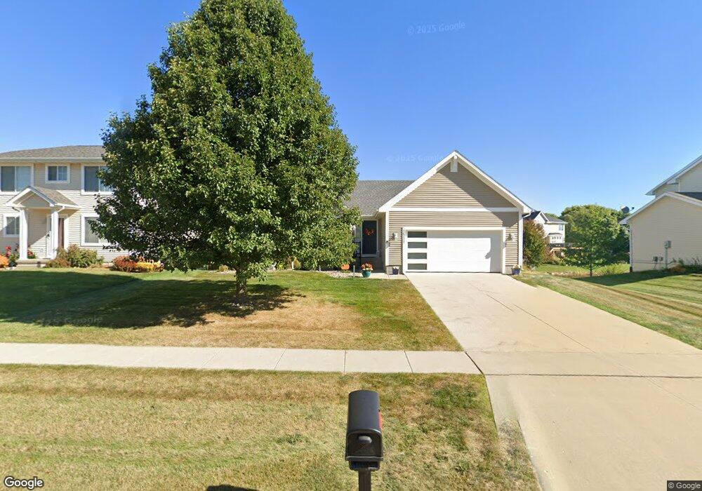
1511 Nine Iron Dr West Des Moines, IA 50266
Estimated Value: $351,000 - $391,000
4
Beds
3
Baths
1,431
Sq Ft
$258/Sq Ft
Est. Value
About This Home
This home is located at 1511 Nine Iron Dr, West Des Moines, IA 50266 and is currently estimated at $369,496, approximately $258 per square foot. 1511 Nine Iron Dr is a home located in Dallas County with nearby schools including Maple Grove Elementary School, Prairieview Middle School, and South Middle School.
Ownership History
Date
Name
Owned For
Owner Type
Purchase Details
Closed on
Aug 7, 2025
Sold by
Schroeder Linda L
Bought by
Linda L Schroeder Trust and Schroeder
Current Estimated Value
Purchase Details
Closed on
Jul 19, 2005
Sold by
Midland Homes Lc
Bought by
Schroeder Curtis L and Schroeder Linda
Home Financials for this Owner
Home Financials are based on the most recent Mortgage that was taken out on this home.
Original Mortgage
$63,000
Interest Rate
5.66%
Mortgage Type
New Conventional
Create a Home Valuation Report for This Property
The Home Valuation Report is an in-depth analysis detailing your home's value as well as a comparison with similar homes in the area
Home Values in the Area
Average Home Value in this Area
Purchase History
| Date | Buyer | Sale Price | Title Company |
|---|---|---|---|
| Linda L Schroeder Trust | -- | None Listed On Document | |
| Schroeder Curtis L | $213,500 | None Available | |
| Midland Homes Lc | -- | None Available |
Source: Public Records
Mortgage History
| Date | Status | Borrower | Loan Amount |
|---|---|---|---|
| Previous Owner | Midland Homes Lc | $63,000 |
Source: Public Records
Tax History Compared to Growth
Tax History
| Year | Tax Paid | Tax Assessment Tax Assessment Total Assessment is a certain percentage of the fair market value that is determined by local assessors to be the total taxable value of land and additions on the property. | Land | Improvement |
|---|---|---|---|---|
| 2024 | $5,424 | $348,820 | $65,000 | $283,820 |
| 2023 | $5,424 | $348,820 | $65,000 | $283,820 |
| 2022 | $5,012 | $298,580 | $55,000 | $243,580 |
| 2021 | $5,012 | $279,840 | $50,000 | $229,840 |
| 2020 | $4,700 | $254,730 | $50,000 | $204,730 |
| 2019 | $4,784 | $254,730 | $50,000 | $204,730 |
| 2018 | $4,784 | $247,230 | $50,000 | $197,230 |
| 2017 | $4,804 | $247,230 | $50,000 | $197,230 |
| 2016 | $4,366 | $226,250 | $38,410 | $187,840 |
| 2015 | $4,236 | $226,250 | $0 | $0 |
| 2014 | $4,236 | $200,030 | $0 | $0 |
Source: Public Records
Map
Nearby Homes
- 9023 Linden Dr
- 8832 Kingman Dr
- 1594 Nine Iron Dr
- 10773 Silver St
- 10757 Silver St
- 10745 Silver St
- 10731 Silver St
- 10719 Silver St
- 10707 Silver St
- 10683 Silver St
- 10675 Silver St
- 3918 Silver St
- 10843 Silver St
- 10815 Silver St
- 10829 Silver St
- 10857 Silver St
- 10860 Silver St
- 10846 Silver St
- 10832 Silver St
- 10818 Silver St
- 1521 Nine Iron Dr
- 1503 Nine Iron Dr
- 1533 Nine Iron Dr
- 8896 Golf Cir
- 8874 Golf Cir
- 1491 Nine Iron Dr
- 1510 Nine Iron Dr
- 1518 Nine Iron Dr
- 8912 Golf Cir
- 1502 Nine Iron Dr
- 8852 Golf Cir
- 1541 Nine Iron Dr
- 1475 Nine Iron Dr
- 1490 Nine Iron Dr
- 1538 Nine Iron Dr
- 8924 Golf Cir
- 1549 Nine Iron Dr
- 1482 Nine Iron Dr
- 1546 Nine Iron Dr
- 1470 Nine Iron Dr