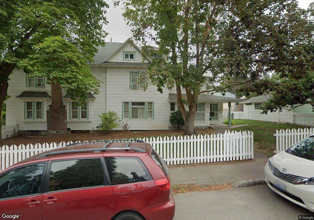
1511 S Adams St Spokane, WA 99203
Cliff-Cannon NeighborhoodEstimated Value: $519,000 - $688,000
7
Beds
4
Baths
3,391
Sq Ft
$177/Sq Ft
Est. Value
About This Home
This home is located at 1511 S Adams St, Spokane, WA 99203 and is currently estimated at $600,185, approximately $176 per square foot. 1511 S Adams St is a home located in Spokane County with nearby schools including Roosevelt Elementary School, Sacajawea Middle School, and Lewis & Clark High School.
Ownership History
Date
Name
Owned For
Owner Type
Purchase Details
Closed on
Dec 13, 2023
Sold by
Hoerner Marilyn A
Bought by
Macalalad Elias and Macalalad Sharon Lynnette
Current Estimated Value
Home Financials for this Owner
Home Financials are based on the most recent Mortgage that was taken out on this home.
Original Mortgage
$320,000
Outstanding Balance
$314,948
Interest Rate
7.76%
Mortgage Type
New Conventional
Estimated Equity
$285,237
Create a Home Valuation Report for This Property
The Home Valuation Report is an in-depth analysis detailing your home's value as well as a comparison with similar homes in the area
Home Values in the Area
Average Home Value in this Area
Purchase History
| Date | Buyer | Sale Price | Title Company |
|---|---|---|---|
| Macalalad Elias | $320,000 | Wfg National Title |
Source: Public Records
Mortgage History
| Date | Status | Borrower | Loan Amount |
|---|---|---|---|
| Open | Macalalad Elias | $320,000 |
Source: Public Records
Tax History Compared to Growth
Tax History
| Year | Tax Paid | Tax Assessment Tax Assessment Total Assessment is a certain percentage of the fair market value that is determined by local assessors to be the total taxable value of land and additions on the property. | Land | Improvement |
|---|---|---|---|---|
| 2025 | $5,396 | $683,800 | $130,000 | $553,800 |
| 2024 | $5,396 | $544,200 | $100,000 | $444,200 |
| 2023 | $5,473 | $593,000 | $85,000 | $508,000 |
| 2022 | $5,170 | $560,100 | $84,000 | $476,100 |
| 2021 | $4,635 | $390,000 | $77,200 | $312,800 |
| 2020 | $4,586 | $371,800 | $75,000 | $296,800 |
| 2019 | $3,744 | $313,300 | $50,400 | $262,900 |
| 2018 | $4,007 | $288,200 | $42,000 | $246,200 |
| 2017 | $3,549 | $259,920 | $37,520 | $222,400 |
| 2016 | $3,616 | $259,120 | $37,520 | $221,600 |
| 2015 | $3,555 | $249,200 | $32,000 | $217,200 |
| 2014 | -- | $249,200 | $32,000 | $217,200 |
| 2013 | -- | $0 | $0 | $0 |
Source: Public Records
Map
Nearby Homes
- 1304 W 15th Ave
- 1507 S Walnut St
- 2832 W 13th Ave
- 2812 W 13th Ave
- 2820 W 13th Ave
- 1212 W 12th Ave
- 1823 S Maple Blvd
- 1115 S Cedar St
- 1509 W 12th Ave
- 918 W 18th Ave
- 1908 S Cedar St
- 1107 W 19th Ave
- 1130 W 11th Ave
- 927 S Adams St
- 844 W Cliff Dr Unit 107
- 844 W Cliff Dr Unit 303
- 844 W Cliff Dr Unit 206
- 1424 W 10th Ave
- 1428 W 10th Ave
- 1618 W 11th Ave
- 1229 W 15th Ave
- 1223 W 15th Ave
- 1215 W 15th Ave
- 1519 S Adams St
- 1502 S Adams St
- 1514 S Adams St
- 1523 S Adams St
- 1429 S Adams St
- 1211 W 15th Ave
- 1518 S Adams St
- 1218 W 16th Ave
- 1524 S Adams St
- 1214 W 16th Ave
- 1423 S Adams St
- 1311 W 15th Ave
- 1506 S Jefferson St
- 1528 S Adams St
- 1512 S Jefferson St
- 1208 W 16th Ave
- 1214 W 15th Ave