Estimated Value: $196,000 - $258,000
3
Beds
1
Bath
1,038
Sq Ft
$220/Sq Ft
Est. Value
About This Home
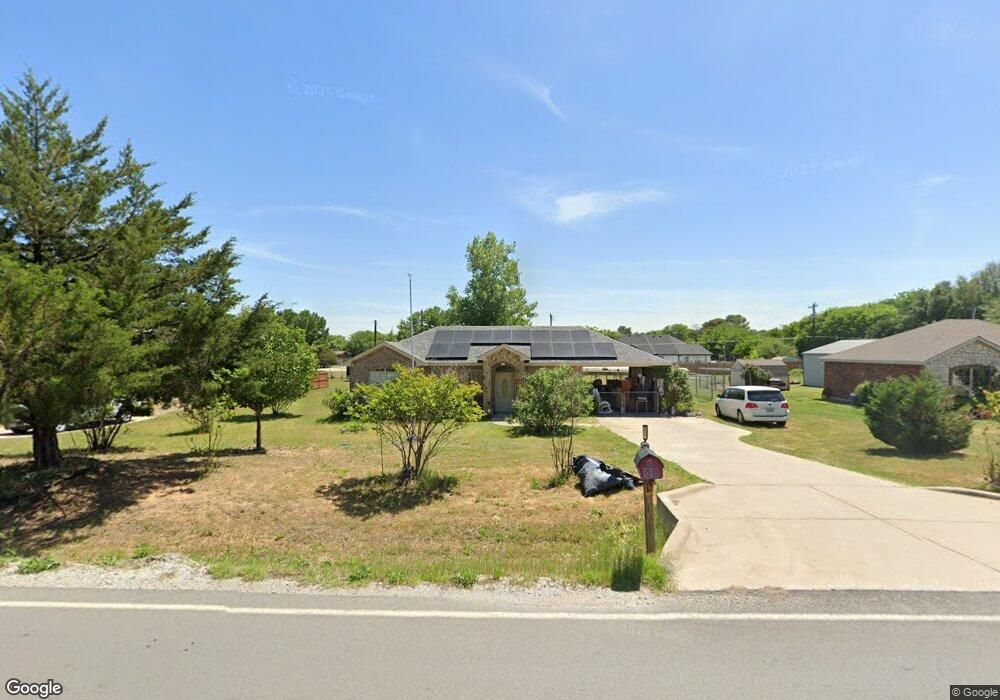
This home is located at 1512 Sandy Beach Rd, Azle, TX 76020 and is currently estimated at $228,290, approximately $219 per square foot. 1512 Sandy Beach Rd is a home located in Tarrant County with nearby schools including Liberty Elementary School, W E Hoover Elementary School, and Santo Forte Junior High School.
Ownership History
Date
Name
Owned For
Owner Type
Purchase Details
Closed on
Jun 22, 2011
Sold by
Thurman Homes Inc
Bought by
Bouchard Kenneth R and Bouchard Christine E
Current Estimated Value
Home Financials for this Owner
Home Financials are based on the most recent Mortgage that was taken out on this home.
Original Mortgage
$81,800
Outstanding Balance
$56,576
Interest Rate
4.7%
Mortgage Type
Seller Take Back
Estimated Equity
$171,714
Create a Home Valuation Report for This Property
The Home Valuation Report is an in-depth analysis detailing your home's value as well as a comparison with similar homes in the area
Home Values in the Area
Average Home Value in this Area
Purchase History
| Date | Buyer | Sale Price | Title Company |
|---|---|---|---|
| Bouchard Kenneth R | $96,000 | None Available |
Source: Public Records
Mortgage History
| Date | Status | Borrower | Loan Amount |
|---|---|---|---|
| Open | Bouchard Kenneth R | $81,800 |
Source: Public Records
Tax History Compared to Growth
Tax History
| Year | Tax Paid | Tax Assessment Tax Assessment Total Assessment is a certain percentage of the fair market value that is determined by local assessors to be the total taxable value of land and additions on the property. | Land | Improvement |
|---|---|---|---|---|
| 2025 | $1,360 | $219,648 | $59,700 | $159,948 |
| 2024 | $1,360 | $219,648 | $59,700 | $159,948 |
| 2023 | $5,053 | $235,039 | $59,700 | $175,339 |
| 2022 | $3,816 | $179,036 | $27,860 | $151,176 |
| 2021 | $3,730 | $153,299 | $27,860 | $125,439 |
| 2020 | $3,391 | $130,830 | $14,000 | $116,830 |
| 2019 | $3,170 | $131,362 | $14,000 | $117,362 |
| 2018 | $1,714 | $101,422 | $14,000 | $87,422 |
| 2017 | $2,533 | $93,647 | $14,000 | $79,647 |
| 2016 | $2,303 | $96,446 | $14,000 | $82,446 |
| 2015 | $1,388 | $76,200 | $14,000 | $62,200 |
| 2014 | $1,388 | $76,200 | $14,000 | $62,200 |
Source: Public Records
Map
Nearby Homes
- 1921 Pelican Dr N
- 1934 Long Cir
- 1941 Gale Dr
- 1436 Lakeview Dr
- 1357 Beach Dr
- 1616 Sandy Beach Rd
- 1820 Pelican Dr N
- 1804 Coral Rd
- 1409 Eagle Nest Dr
- 1441 Yachtclub Dr
- 1701 Sheila Dr
- 1709 Sheila Dr
- 1532 Gale Dr
- 1417 Gilley Trail
- 11335 Eustace Dr
- 11314 Stanfield Dr
- 1633 Long Ave
- 1534 Gale Dr
- 1618 Gale Dr
- 101 Gordon Dr
- 1508 Sandy Beach Rd
- 1516 Sandy Beach Rd
- 1504 Sandy Beach Rd
- 1520 Sandy Beach Rd
- 1916 Coral Rd
- 1500 Sandy Beach Rd
- 1524 Sandy Beach Rd
- 12224 Lighthouse Hill
- 1920 Reef Ct
- 1917 Coral Rd
- 1912 Coral Rd
- 1304 Beach Dr
- 12228 Lighthouse Hill
- 1440 Sandy Beach Rd
- 1308 Beach Dr
- 1528 Sandy Beach Rd
- 1925 Pelican Dr N
- 12220 Lighthouse Hill
- 1312 Beach Dr
- 1917 Pelican Dr N