1513 Sylvan Cir Brandon, SD 57005
Estimated payment $2,661/month
Highlights
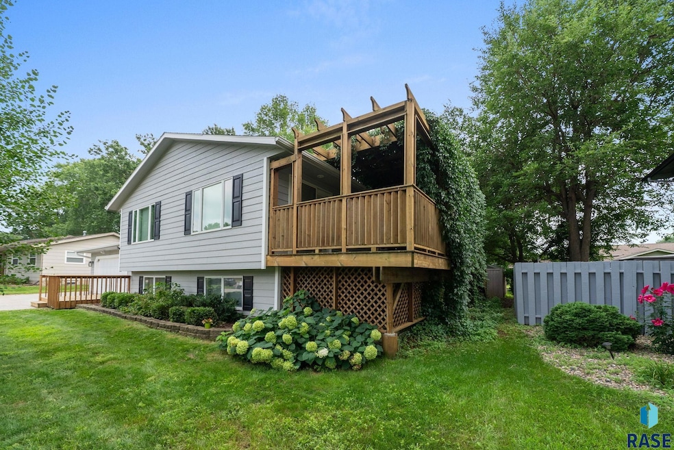
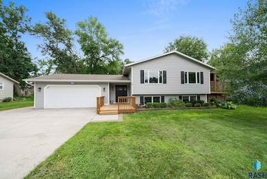
- Deck
- No HOA
- Laundry Room
- Brandon Elementary School Rated A
- Patio
- Shed
About This Home
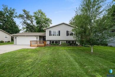
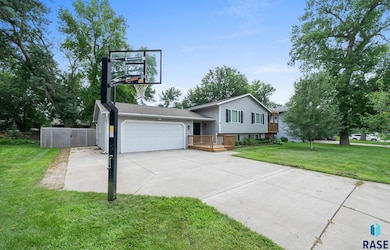
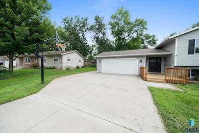
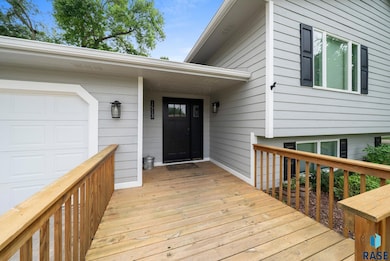
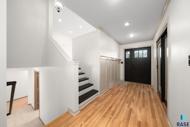
Truly Move-In Ready in Brandon! This stunning 5-bedroom, 2.5-bath split foyer has been thoughtfully updated from top to bottom. You’ll love the instant curb appeal with beautiful exterior paint, refreshed siding, shutters, and a welcoming craftsman-style front door. Inside, the main level showcases an airy, open layout with a spacious living room, dining area, office, and a beautifully updated kitchen featuring granite counters, stainless steel appliances, a brand-new pantry, and plenty of cabinetry. Step through the sliding door to a generous 28X11 cedar deck with pergola—perfect for gatherings or quiet evenings. Throughout the home, you’ll find 400 Series Anderson windows, a striking stone gas fireplace, and custom built-ins in the basement. Bathrooms shine with modern updates, while the finished laundry room adds convenience and style. Retreat to the lower-level primary suite complete with double closets and a spa-like bathroom offering dual granite vanities, heated tile floor, tiled walk-in shower, and a jetted tub. The oversized 2-stall garage is equipped with a gas heater, storage space, and direct access to the patio with a hot tub hookup. A newer privacy fence surrounds the backyard oasis. Recent upgrades include fresh interior paint, main floor bathroom remodels, and added pantry. Also newer flooring, garage door, shed with electricity, siding, furnace, and A/C.
Home Details
Home Type
- Single Family
Est. Annual Taxes
- $5,141
Year Built
- Built in 1975
Lot Details
- 9,988 Sq Ft Lot
- Lot Dimensions are 117 x 85
- Garden
Parking
- 2 Car Garage
Home Design
- Split Foyer
- Block Foundation
- Composition Roof
Interior Spaces
- 2,600 Sq Ft Home
- Gas Fireplace
- Basement Fills Entire Space Under The House
Kitchen
- Microwave
- Dishwasher
- Disposal
Flooring
- Carpet
- Laminate
- Tile
Bedrooms and Bathrooms
- 5 Bedrooms
Laundry
- Laundry Room
- Dryer
- Washer
Outdoor Features
- Deck
- Patio
- Shed
Schools
- Brandon Elementary School
- Brandon Valley Middle School
- Brandon Valley High School
Additional Features
- City Lot
- Heating Available
Community Details
- No Home Owners Association
- Brandon Park Addition To City Of Brandon Subdivision
Map
Home Values in the Area
Average Home Value in this Area
Tax History
| Year | Tax Paid | Tax Assessment Tax Assessment Total Assessment is a certain percentage of the fair market value that is determined by local assessors to be the total taxable value of land and additions on the property. | Land | Improvement |
|---|---|---|---|---|
| 2024 | $5,141 | $382,900 | $30,900 | $352,000 |
| 2023 | $4,750 | $334,700 | $30,900 | $303,800 |
| 2022 | $3,993 | $264,300 | $30,900 | $233,400 |
| 2021 | $3,551 | $220,600 | $0 | $0 |
| 2020 | $3,551 | $219,400 | $0 | $0 |
| 2019 | $3,508 | $212,313 | $0 | $0 |
| 2018 | $3,117 | $201,269 | $0 | $0 |
| 2017 | $3,123 | $187,422 | $28,263 | $159,159 |
| 2016 | $3,123 | $184,528 | $28,263 | $156,265 |
| 2015 | $3,104 | $176,138 | $26,243 | $149,895 |
| 2014 | -- | $168,932 | $26,243 | $142,689 |
Property History
| Date | Event | Price | List to Sale | Price per Sq Ft |
|---|---|---|---|---|
| 01/27/2026 01/27/26 | Pending | -- | -- | -- |
| 10/14/2025 10/14/25 | Price Changed | $430,000 | -4.2% | $165 / Sq Ft |
| 09/22/2025 09/22/25 | Price Changed | $449,000 | -3.4% | $173 / Sq Ft |
| 08/05/2025 08/05/25 | For Sale | $465,000 | -- | $179 / Sq Ft |
Purchase History
| Date | Type | Sale Price | Title Company |
|---|---|---|---|
| Warranty Deed | $428,000 | -- | |
| Warranty Deed | $428,000 | -- |
Mortgage History
| Date | Status | Loan Amount | Loan Type |
|---|---|---|---|
| Open | $365,500 | No Value Available | |
| Closed | $365,500 | No Value Available |
Source: REALTOR® Association of the Sioux Empire
MLS Number: 22506029
APN: 20729
Disclaimer: Certain information contained herein is derived from information provided by parties other than Homes.com. All information provided is deemed reliable, but is not guaranteed to be accurate and should be independently verified.
![]() The data relating to real estate for sale on this web site comes in part from the Internet Data Exchange Program of the REALTOR® Association of the Sioux Empire, Inc., Multiple Listing Service. Real estate listings held by brokerage firms other than Ten-X are marked with the Internet Data Exchange™ logo or the Internet Data Exchange thumbnail logo (a little black house) and detailed information about them includes the name of the listing brokers.
The data relating to real estate for sale on this web site comes in part from the Internet Data Exchange Program of the REALTOR® Association of the Sioux Empire, Inc., Multiple Listing Service. Real estate listings held by brokerage firms other than Ten-X are marked with the Internet Data Exchange™ logo or the Internet Data Exchange thumbnail logo (a little black house) and detailed information about them includes the name of the listing brokers.
Information is deemed reliable but not guaranteed.
Copyright 2026 REALTOR® Association of the Sioux Empire, Inc., Inc. Multiple Listing Service. All rights reserved.
- 1601 E Sylvan Cir
- 1617 E Sylvan Cir
- 104 S Needles Dr
- 108 S Needles Dr
- 101 Pipestone St Unit 2
- 101 Pipestone St Unit 4
- 1411 Rushmore Dr
- 600 N Yellowstone Dr
- 300 Fairway Cir Cir
- 410 9th Ave
- 2516 E Chestnut Trail
- 2500 E Chestnut Trail
- 609 S Splitrock Blvd
- 404 S 8th Ave
- 1000 Maywood St
- 304 S Country Club Ave
- 909 S Country Club Ave
- 905 S Country Club Ave
- 917 S Country Club Ave
- 901 S Country Club Ave
