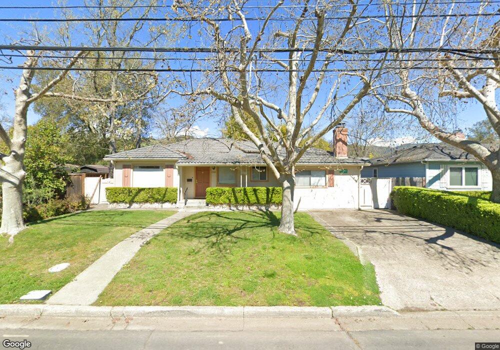
1518 Grant St Calistoga, CA 94515
Estimated Value: $687,224 - $1,077,000
2
Beds
1
Bath
1,065
Sq Ft
$808/Sq Ft
Est. Value
About This Home
This home is located at 1518 Grant St, Calistoga, CA 94515 and is currently estimated at $860,806, approximately $808 per square foot. 1518 Grant St is a home located in Napa County with nearby schools including Calistoga Elementary School and Calistoga Junior/Senior High School.
Ownership History
Date
Name
Owned For
Owner Type
Purchase Details
Closed on
May 18, 2007
Sold by
Manderfeld Robert H and Manderfeld Dora A
Bought by
Manderfeld John R
Current Estimated Value
Home Financials for this Owner
Home Financials are based on the most recent Mortgage that was taken out on this home.
Original Mortgage
$410,000
Outstanding Balance
$248,709
Interest Rate
6.12%
Mortgage Type
Purchase Money Mortgage
Estimated Equity
$612,097
Purchase Details
Closed on
May 19, 2004
Sold by
Manderfeld Robert H and Manderfeld Dora A
Bought by
Manderfeld Robert H and Manderfeld Dora A
Create a Home Valuation Report for This Property
The Home Valuation Report is an in-depth analysis detailing your home's value as well as a comparison with similar homes in the area
Home Values in the Area
Average Home Value in this Area
Purchase History
| Date | Buyer | Sale Price | Title Company |
|---|---|---|---|
| Manderfeld John R | $750,000 | North American Title Company | |
| Manderfeld Robert H | -- | -- |
Source: Public Records
Mortgage History
| Date | Status | Borrower | Loan Amount |
|---|---|---|---|
| Open | Manderfeld John R | $410,000 |
Source: Public Records
Tax History Compared to Growth
Tax History
| Year | Tax Paid | Tax Assessment Tax Assessment Total Assessment is a certain percentage of the fair market value that is determined by local assessors to be the total taxable value of land and additions on the property. | Land | Improvement |
|---|---|---|---|---|
| 2024 | $1,256 | $109,730 | $13,880 | $95,850 |
| 2023 | $1,256 | $107,579 | $13,608 | $93,971 |
| 2022 | $1,179 | $105,471 | $13,342 | $92,129 |
| 2021 | $1,142 | $103,404 | $13,081 | $90,323 |
| 2020 | $1,127 | $102,344 | $12,947 | $89,397 |
| 2019 | $1,112 | $100,339 | $12,694 | $87,645 |
| 2018 | $1,099 | $98,373 | $12,446 | $85,927 |
| 2017 | $1,076 | $96,445 | $12,202 | $84,243 |
| 2016 | $1,039 | $94,555 | $11,963 | $82,592 |
| 2015 | $1,027 | $93,136 | $11,784 | $81,352 |
| 2014 | $1,009 | $91,313 | $11,554 | $79,759 |
Source: Public Records
Map
Nearby Homes
- Residence 2 Plan at Silverado Terrace
- Residence 3 Plan at Silverado Terrace
- Residence 1 Plan at Silverado Terrace
- 1438 Grant St
- 33 Brannan St
- 1607 Harley St
- 1705 Adele St
- 1437 4th St
- 1431 4th St
- 34 Magnolia Dr
- 1411 4th St
- 33 Magnolia Dr
- 1422 N Oak St
- 800 Washington St
- 209 Champagne W
- 320 Chablis N
- 2103 Oat Hill Ct
- 1610 Myrtle St
- 937 Champagne S
- 2115 Oat Hill Ct