1520 Canton Dr Milpitas, CA 95035
Estimated Value: $1,131,000 - $1,416,580
About This Home
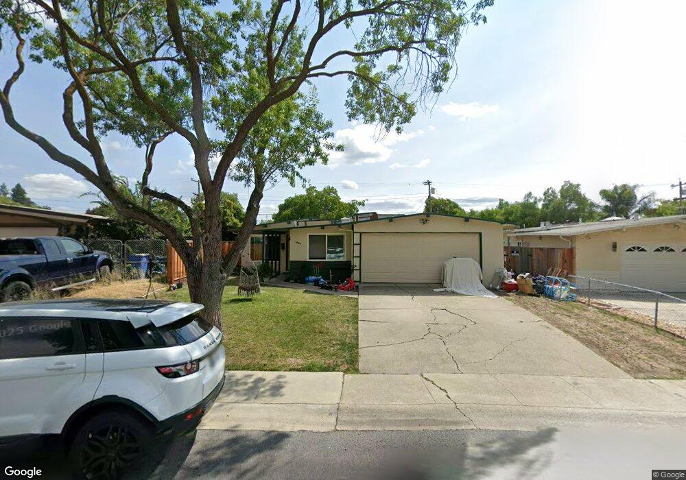
This home is located at 1520 Canton Dr, Milpitas, CA 95035 and is currently estimated at $1,255,395, approximately $1,057 per square foot. 1520 Canton Dr is a home located in Santa Clara County with nearby schools including Alexander Rose Elementary School, Rancho Milpitas Middle School, and Milpitas High School.
Ownership History
We collect this data history from publicly available records. To have your information removed, we recommend requesting removal directly through your county’s website.
Purchase Details
Purchase Details
Home Financials for this Owner
Home Financials are based on the most recent Mortgage that was taken out on this home.Home Values in the Area
Average Home Value in this Area
Purchase History
We collect this data history from publicly available records. To have your information removed, we recommend requesting removal directly through your county’s website.
| Date | Buyer | Sale Price | Title Company |
|---|---|---|---|
| -- | None Available | ||
| -- | -- |
Mortgage History
We collect this data history from publicly available records. To have your information removed, we recommend requesting removal directly through your county’s website.
| Date | Status | Borrower | Loan Amount |
|---|---|---|---|
| Previous Owner | $1,800,000 |
Tax History
We collect this data history from publicly available records. To have your information removed, we recommend requesting removal directly through your county’s website.
| Year | Tax Paid | Tax Assessment Tax Assessment Total Assessment is a certain percentage of the fair market value that is determined by local assessors to be the total taxable value of land and additions on the property. | Land | Improvement |
|---|---|---|---|---|
| 2025 | $959 | $61,384 | $22,144 | $39,240 |
| 2024 | $959 | $60,181 | $21,710 | $38,471 |
| 2023 | $955 | $59,002 | $21,285 | $37,717 |
| 2022 | $955 | $57,846 | $20,868 | $36,978 |
| 2021 | $942 | $56,712 | $20,459 | $36,253 |
| 2020 | $927 | $56,132 | $20,250 | $35,882 |
| 2019 | $921 | $55,032 | $19,853 | $35,179 |
| 2018 | $885 | $53,954 | $19,464 | $34,490 |
| 2017 | $875 | $52,897 | $19,083 | $33,814 |
| 2016 | $836 | $51,860 | $18,709 | $33,151 |
| 2015 | $828 | $51,082 | $18,428 | $32,654 |
| 2014 | $790 | $50,083 | $18,068 | $32,015 |
Map
- 170 S Gadsden Dr
- 1323 Canton Dr
- 397 S Park Victoria Dr
- 480 Dempsey Rd Unit 283
- 92 Hemlock Ln
- 436 Dempsey Rd Unit 238
- 1864 Edsel Dr
- 1394 Glacier Dr
- 122 Piedmont Rd
- 1490 Olympic Dr
- 1865 Big Bend Dr
- 360 Gerald Cir
- 1260 Glacier Dr
- 2222 Lacey Dr
- 908 Smith Ln
- 69 Henriques Ln
- 1995 Old Calaveras Rd
- 2375 Old Calaveras Rd
- 640 Calle Del Prado
- 642 Aberdeen Way
- 1500 Canton Dr
- 1530 Canton Dr
- 1496 Canton Dr
- 1491 Ashland Dr
- 1497 Ashland Dr
- 1485 Ashland Dr
- 215 Roswell Dr
- 1484 Canton Dr
- 1479 Ashland Dr
- 225 Roswell Dr
- 1505 Ashland Dr
- 1521 Canton Dr
- 1515 Ashland Dr
- 195 Roswell Dr
- 1511 Canton Dr
- 1473 Ashland Dr
- 1476 Canton Dr
- 1501 Canton Dr
- 1529 Ashland Dr
- 185 Roswell Dr
Ask me questions while you tour the home.