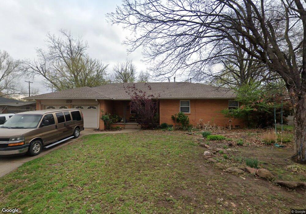
1521 Leslie Ln Norman, OK 73069
Southwest Norman NeighborhoodEstimated Value: $269,000 - $329,000
2
Beds
2
Baths
1,716
Sq Ft
$174/Sq Ft
Est. Value
About This Home
This home is located at 1521 Leslie Ln, Norman, OK 73069 and is currently estimated at $298,810, approximately $174 per square foot. 1521 Leslie Ln is a home located in Cleveland County with nearby schools including Jackson Elementary School, Alcott Middle School, and Norman High School.
Ownership History
Date
Name
Owned For
Owner Type
Purchase Details
Closed on
Sep 10, 2015
Sold by
Robbins Lindsey and Robbins Donald
Bought by
Eberle Thomas M and Eberle Julia A
Current Estimated Value
Home Financials for this Owner
Home Financials are based on the most recent Mortgage that was taken out on this home.
Original Mortgage
$152,800
Outstanding Balance
$120,341
Interest Rate
3.99%
Mortgage Type
New Conventional
Estimated Equity
$178,469
Purchase Details
Closed on
May 9, 2008
Sold by
Pippins Timothy Dale and Pippins Darcy L
Bought by
Scott Lindsey B
Home Financials for this Owner
Home Financials are based on the most recent Mortgage that was taken out on this home.
Original Mortgage
$159,964
Interest Rate
5.86%
Mortgage Type
FHA
Purchase Details
Closed on
Mar 13, 2002
Sold by
Howard Frank W-Trust Howard Frank W-
Bought by
Pippins Timothy Dale
Create a Home Valuation Report for This Property
The Home Valuation Report is an in-depth analysis detailing your home's value as well as a comparison with similar homes in the area
Home Values in the Area
Average Home Value in this Area
Purchase History
| Date | Buyer | Sale Price | Title Company |
|---|---|---|---|
| Eberle Thomas M | $191,000 | Fatco | |
| Scott Lindsey B | $162,500 | None Available | |
| Pippins Timothy Dale | $115,000 | -- |
Source: Public Records
Mortgage History
| Date | Status | Borrower | Loan Amount |
|---|---|---|---|
| Open | Eberle Thomas M | $152,800 | |
| Previous Owner | Scott Lindsey B | $159,964 |
Source: Public Records
Tax History Compared to Growth
Tax History
| Year | Tax Paid | Tax Assessment Tax Assessment Total Assessment is a certain percentage of the fair market value that is determined by local assessors to be the total taxable value of land and additions on the property. | Land | Improvement |
|---|---|---|---|---|
| 2024 | $2,958 | $24,693 | $4,482 | $20,211 |
| 2023 | $2,825 | $23,517 | $4,175 | $19,342 |
| 2022 | $2,564 | $22,269 | $2,400 | $19,869 |
| 2021 | $2,703 | $22,269 | $2,400 | $19,869 |
| 2020 | $2,645 | $22,269 | $2,400 | $19,869 |
| 2019 | $2,690 | $22,269 | $2,400 | $19,869 |
| 2018 | $2,610 | $22,269 | $2,400 | $19,869 |
| 2017 | $2,639 | $22,269 | $0 | $0 |
| 2016 | $2,682 | $22,269 | $2,400 | $19,869 |
| 2015 | $1,957 | $17,758 | $1,373 | $16,385 |
| 2014 | $1,916 | $17,241 | $1,333 | $15,908 |
Source: Public Records
Map
Nearby Homes
- 1614 Cruce St
- 1221 Cruce St
- 1626 Lenox Dr
- 1222 Windsor Way
- 1424 Avondale Dr
- 1202 Windsor Way
- 1527 Camden Way
- 832 Carriage Ln
- 1510 Melrose Dr
- 2012 W Boyd St
- 531 S Berry Rd
- 1125 W Apache St
- 110 S Sherry Ave
- 720 Jona Kay Terrace
- 905 Jona Kay Terrace
- 711 Westridge Terrace
- 1017 Mcfarland St
- 324 Thompson Dr
- 444 S Pickard Ave
- 206 Collier Dr