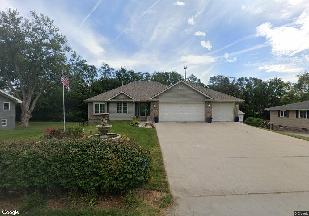
15233 State Orchard Rd Council Bluffs, IA 51503
Eastern Council Bluffs NeighborhoodEstimated Value: $415,000 - $522,000
3
Beds
2
Baths
1,626
Sq Ft
$293/Sq Ft
Est. Value
About This Home
This home is located at 15233 State Orchard Rd, Council Bluffs, IA 51503 and is currently estimated at $475,774, approximately $292 per square foot. 15233 State Orchard Rd is a home located in Pottawattamie County with nearby schools including E.A. Kreft Primary School, Titan Hill Intermediate School, and Lewis Central Middle School.
Ownership History
Date
Name
Owned For
Owner Type
Purchase Details
Closed on
May 6, 2025
Sold by
Kinart Phil V and Kinart Julie A
Bought by
Phil V And Julie A Kinart Revocable Living Tr and Kinart
Current Estimated Value
Purchase Details
Closed on
Oct 22, 2024
Sold by
Kinart Phil V and Kinart Julie A
Bought by
Phil V And Julie A Kinart Revocable Living Tr and Kinart
Purchase Details
Closed on
Mar 14, 2006
Sold by
Uncle Bubba Inc
Bought by
Kinart Phil and Kinart Julie A
Home Financials for this Owner
Home Financials are based on the most recent Mortgage that was taken out on this home.
Original Mortgage
$255,000
Interest Rate
6.38%
Mortgage Type
VA
Create a Home Valuation Report for This Property
The Home Valuation Report is an in-depth analysis detailing your home's value as well as a comparison with similar homes in the area
Home Values in the Area
Average Home Value in this Area
Purchase History
| Date | Buyer | Sale Price | Title Company |
|---|---|---|---|
| Phil V And Julie A Kinart Revocable Living Tr | -- | None Listed On Document | |
| Phil V And Julie A Kinart Revocable Living Tr | -- | None Listed On Document | |
| Kinart Phil | $280,000 | None Available |
Source: Public Records
Mortgage History
| Date | Status | Borrower | Loan Amount |
|---|---|---|---|
| Previous Owner | Kinart Phil | $255,000 |
Source: Public Records
Tax History Compared to Growth
Tax History
| Year | Tax Paid | Tax Assessment Tax Assessment Total Assessment is a certain percentage of the fair market value that is determined by local assessors to be the total taxable value of land and additions on the property. | Land | Improvement |
|---|---|---|---|---|
| 2025 | $4,830 | $489,200 | $53,600 | $435,600 |
| 2024 | $4,830 | $444,900 | $46,700 | $398,200 |
| 2023 | $4,614 | $444,900 | $46,700 | $398,200 |
| 2022 | $3,882 | $317,800 | $36,400 | $281,400 |
| 2021 | $5,965 | $317,800 | $36,400 | $281,400 |
| 2020 | $4,352 | $317,800 | $36,400 | $281,400 |
| 2019 | $4,544 | $317,800 | $36,400 | $281,400 |
| 2018 | $3,982 | $317,800 | $36,400 | $281,400 |
| 2017 | $3,982 | $286,254 | $27,497 | $258,757 |
| 2015 | $4,054 | $286,254 | $27,497 | $258,757 |
| 2014 | $4,084 | $286,254 | $27,497 | $258,757 |
Source: Public Records
Map
Nearby Homes
- 108 Essex Ave
- 20425 Greenview Rd
- 15365 Crestview Dr
- 20.57 AC. M L State Orchard Rd
- 218 Brent Ln
- 411 Redwood Dr
- 1843 Sycamore St
- 1800 Sycamore St
- 3 Lilac Cir
- 1780 Blackthorn St
- 31 Balsam Cir
- 1896 Balsam St
- 23 Balsam Cir
- 1897 Hemlock St
- 19 Balsam Cir
- 1896 Hemlock St
- 131 Norwood Dr
- 3 Bayberry Cir
- 1768 Blackthorn St
- LOT 10 Fannin Cir
- 15211 State Orchard Rd
- 15261 State Orchard Rd
- 15212 State Orchard Rd
- 15189 State Orchard Rd
- 15248 State Orchard Rd
- 15163 State Orchard Rd
- 20480 Victoria Dr
- 15147 State Orchard Rd
- 20468 Victoria Dr
- 15174 State Orchard Rd
- 20467 Victoria Dr
- 107 Dorset Ave
- 20460 Victoria Dr
- 111 Dorset Ave
- 109 Dorset Ave
- 15136 State Orchard Rd
- 15127 State Orchard Rd
- 20436 Victoria Dr
- 105 Dorset Ave
- 15330 State Orchard Rd