Estimated Value: $177,000 - $208,011
4
Beds
2
Baths
1,578
Sq Ft
$125/Sq Ft
Est. Value
About This Home
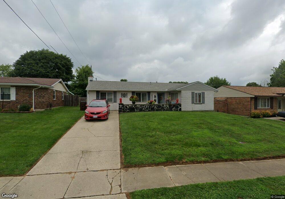
This home is located at 1526 Arrowhead Trail, Xenia, OH 45385 and is currently estimated at $197,503, approximately $125 per square foot. 1526 Arrowhead Trail is a home located in Greene County with nearby schools including Xenia High School, Summit Academy Community School for Alternative Learners - Xenia, and Legacy Christian Academy.
Ownership History
Date
Name
Owned For
Owner Type
Purchase Details
Closed on
Oct 2, 2023
Sold by
Lippincott Mark H and Lippincott Deborah K
Bought by
Mark H Lippincott And Deborah K Lippincott Re and Lippincott
Current Estimated Value
Purchase Details
Closed on
Jan 19, 1990
Bought by
Lippincott Mark H and Lippincott Lippincott
Create a Home Valuation Report for This Property
The Home Valuation Report is an in-depth analysis detailing your home's value as well as a comparison with similar homes in the area
Home Values in the Area
Average Home Value in this Area
Purchase History
| Date | Buyer | Sale Price | Title Company |
|---|---|---|---|
| Mark H Lippincott And Deborah K Lippincott Re | -- | None Listed On Document | |
| Lippincott Mark H | $59,900 | -- |
Source: Public Records
Tax History Compared to Growth
Tax History
| Year | Tax Paid | Tax Assessment Tax Assessment Total Assessment is a certain percentage of the fair market value that is determined by local assessors to be the total taxable value of land and additions on the property. | Land | Improvement |
|---|---|---|---|---|
| 2024 | $2,176 | $52,200 | $10,370 | $41,830 |
| 2023 | $2,176 | $52,200 | $10,370 | $41,830 |
| 2022 | $1,824 | $37,290 | $6,100 | $31,190 |
| 2021 | $1,848 | $37,290 | $6,100 | $31,190 |
| 2020 | $1,769 | $37,290 | $6,100 | $31,190 |
| 2019 | $1,467 | $29,120 | $5,880 | $23,240 |
| 2018 | $1,473 | $29,120 | $5,880 | $23,240 |
| 2017 | $1,333 | $29,120 | $5,880 | $23,240 |
| 2016 | $1,334 | $25,880 | $5,880 | $20,000 |
| 2015 | $1,337 | $25,880 | $5,880 | $20,000 |
| 2014 | $1,279 | $25,880 | $5,880 | $20,000 |
Source: Public Records
Map
Nearby Homes
- 1208 Bellbrook Ave
- 1272 Bellbrook Ave
- 1144 Rockwell Dr
- 1618 Navajo Dr
- 1778 Arapaho Dr
- 1342 Kylemore Dr
- 1568 Cheyenne Dr
- 1653 Seneca Dr
- 1233 June Dr
- 1223 June Dr
- 1769 Gayhart Dr
- 1283 June Dr
- 1391 June Dr
- 1866 Roxbury Dr
- 1829 Gayhart Dr
- 1908 Whitt St
- 2758 Wyoming Dr
- 121 S Progress Dr
- 305-325 Bellbrook Ave
- 523 Newport Rd
- 1538 Arrowhead Trail
- 1514 Arrowhead Trail
- 882 Moccasin Trail
- 1552 Arrowhead Trail
- 887 Tomahawk Trail
- 868 Moccasin Trail
- 1527 Arrowhead Trail
- 1541 Arrowhead Trail
- 1490 Arrowhead Trail
- 1553 Arrowhead Trail
- 891 Moccasin Trail
- 856 Moccasin Trail
- 879 Moccasin Trail
- 861 Tomahawk Trail
- 1478 Arrowhead Trail
- 1565 Arrowhead Trail
- 1491 Arrowhead Trail
- 865 Moccasin Trail
- 894 Tomahawk Trail
- 1526 Wigwam Trail