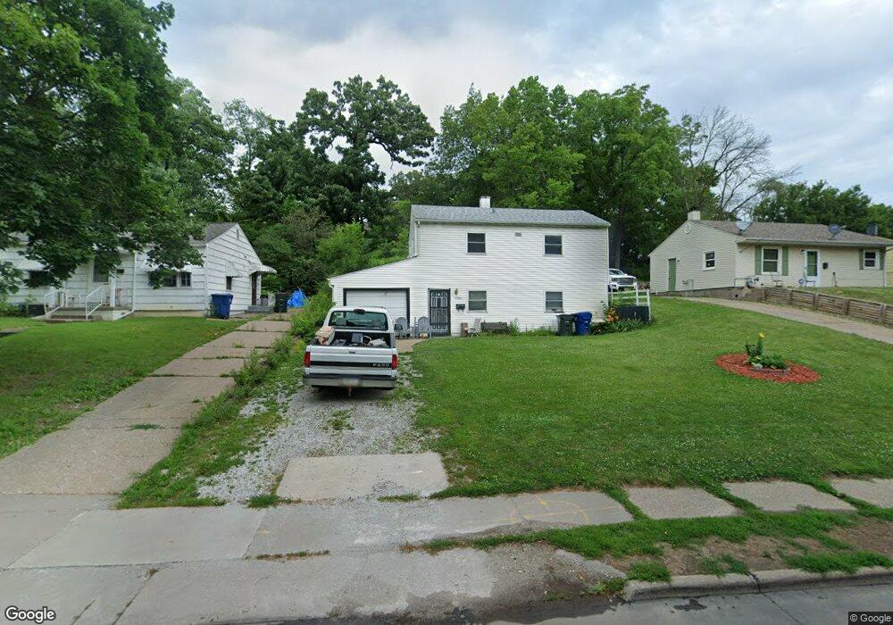
1526 Kirkwood Blvd Davenport, IA 52803
East End NeighborhoodEstimated Value: $94,000 - $108,313
3
Beds
1
Bath
1,200
Sq Ft
$84/Sq Ft
Est. Value
About This Home
This home is located at 1526 Kirkwood Blvd, Davenport, IA 52803 and is currently estimated at $101,078, approximately $84 per square foot. 1526 Kirkwood Blvd is a home located in Scott County with nearby schools including Caverna Elementary School, Casey County Middle School, and Hopkinsville Middle School.
Ownership History
Date
Name
Owned For
Owner Type
Purchase Details
Closed on
Jan 27, 2025
Sold by
Hare Terri and Hare James
Bought by
Hare James
Current Estimated Value
Purchase Details
Closed on
Jan 16, 2025
Sold by
Kroeger Brad and Kroeger Brent
Bought by
Hare James
Create a Home Valuation Report for This Property
The Home Valuation Report is an in-depth analysis detailing your home's value as well as a comparison with similar homes in the area
Home Values in the Area
Average Home Value in this Area
Purchase History
| Date | Buyer | Sale Price | Title Company |
|---|---|---|---|
| Hare James | -- | None Listed On Document | |
| Hare James | -- | None Listed On Document |
Source: Public Records
Tax History Compared to Growth
Tax History
| Year | Tax Paid | Tax Assessment Tax Assessment Total Assessment is a certain percentage of the fair market value that is determined by local assessors to be the total taxable value of land and additions on the property. | Land | Improvement |
|---|---|---|---|---|
| 2025 | $1,330 | $92,850 | $17,790 | $75,060 |
| 2024 | $1,294 | $84,620 | $17,790 | $66,830 |
| 2023 | $1,372 | $84,620 | $17,790 | $66,830 |
| 2022 | $1,378 | $73,140 | $10,170 | $62,970 |
| 2021 | $1,378 | $73,140 | $10,170 | $62,970 |
| 2020 | $1,202 | $64,150 | $10,170 | $53,980 |
| 2019 | $1,248 | $64,150 | $10,170 | $53,980 |
| 2018 | $1,218 | $64,150 | $10,170 | $53,980 |
| 2017 | $357 | $64,150 | $10,170 | $53,980 |
| 2016 | $1,214 | $64,150 | $0 | $0 |
| 2015 | $1,214 | $60,240 | $0 | $0 |
| 2014 | $1,144 | $60,240 | $0 | $0 |
| 2013 | $1,120 | $0 | $0 | $0 |
| 2012 | -- | $52,110 | $14,140 | $37,970 |
Source: Public Records
Map
Nearby Homes
- 1325 Mississippi Ave
- 1310 Kirkwood Blvd
- 1616 Esplanade Ave
- 1626 Esplanade Ave
- 1233 Eastern Ave
- 1202 Adams St
- 1501 Bridge Ave
- 1220 College Ave
- 1102 College Ave
- 1224 E 11th St
- 1504 Christie St
- 1020 E 15th St
- 1004 College Ave
- 2125 Eastern Ave
- 1012 Bridge Ave
- 1920 Carey Ave
- 1603 Arlington Ave
- 1605 Arlington Ave
- 2316 East St
- 1803 Belle Ave
- 1522 Kirkwood Blvd
- 1532 Kirkwood Blvd
- 1606 Kirkwood Blvd
- 1516 Kirkwood Blvd
- 1614 Kirkwood Blvd
- 1512 Kirkwood Blvd
- 1501 Fulton Ct
- 1502 Fulton Ct
- 1618 Kirkwood Blvd
- 1422 Eastern Ave
- 1502 Kirkwood Blvd
- 1505 Fulton Ct
- 1523 Kirkwood Blvd
- 1622 Kirkwood Blvd
- 1529 Kirkwood Blvd
- 1511 Kirkwood Blvd
- 1423 Mississippi Ave
- 1508 Fulton Ct
- 1505 Kirkwood Blvd
- 1330 Adams St