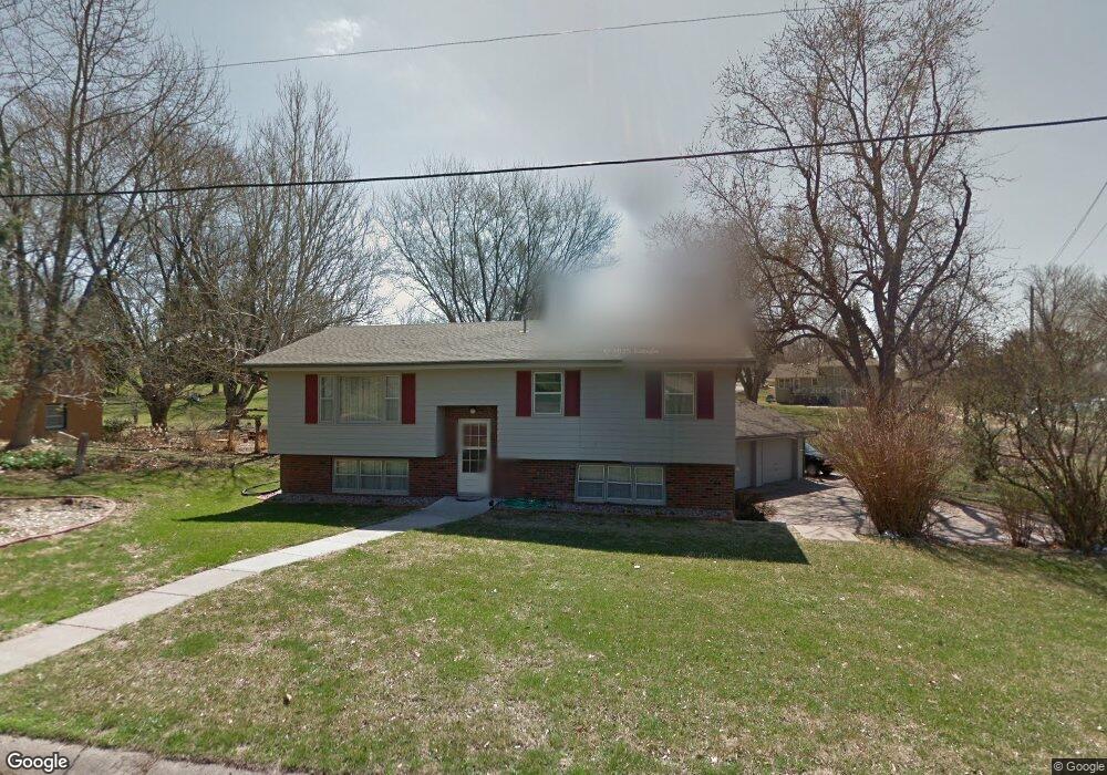
15295 Nall Rd Council Bluffs, IA 51503
Eastern Council Bluffs NeighborhoodEstimated Value: $332,000 - $360,000
4
Beds
2
Baths
2,316
Sq Ft
$148/Sq Ft
Est. Value
About This Home
This home is located at 15295 Nall Rd, Council Bluffs, IA 51503 and is currently estimated at $341,767, approximately $147 per square foot. 15295 Nall Rd is a home located in Pottawattamie County with nearby schools including E.A. Kreft Primary School, Titan Hill Intermediate School, and Lewis Central Middle School.
Ownership History
Date
Name
Owned For
Owner Type
Purchase Details
Closed on
May 28, 2010
Sold by
Buhr Jeremy L
Bought by
Buhr Jeremy L
Current Estimated Value
Purchase Details
Closed on
Apr 16, 2010
Sold by
Duggan Jerry F and Duggan Dolores M
Bought by
Buhr Jeremy L
Purchase Details
Closed on
Jun 14, 2006
Sold by
Pellant L Erwin and Pellant Janice S
Bought by
Buhr Jeremy and Buhr Karen
Home Financials for this Owner
Home Financials are based on the most recent Mortgage that was taken out on this home.
Original Mortgage
$140,000
Interest Rate
6.73%
Mortgage Type
New Conventional
Create a Home Valuation Report for This Property
The Home Valuation Report is an in-depth analysis detailing your home's value as well as a comparison with similar homes in the area
Home Values in the Area
Average Home Value in this Area
Purchase History
| Date | Buyer | Sale Price | Title Company |
|---|---|---|---|
| Buhr Jeremy L | -- | None Available | |
| Buhr Jeremy L | -- | None Available | |
| Buhr Jeremy | $175,000 | Mrt |
Source: Public Records
Mortgage History
| Date | Status | Borrower | Loan Amount |
|---|---|---|---|
| Previous Owner | Buhr Jeremy | $140,000 |
Source: Public Records
Tax History Compared to Growth
Tax History
| Year | Tax Paid | Tax Assessment Tax Assessment Total Assessment is a certain percentage of the fair market value that is determined by local assessors to be the total taxable value of land and additions on the property. | Land | Improvement |
|---|---|---|---|---|
| 2025 | $2,958 | $286,400 | $58,400 | $228,000 |
| 2024 | $2,958 | $261,100 | $50,800 | $210,300 |
| 2023 | $2,830 | $261,100 | $50,800 | $210,300 |
| 2022 | $2,728 | $214,700 | $43,100 | $171,600 |
| 2021 | $4,190 | $214,700 | $43,100 | $171,600 |
| 2020 | $2,664 | $214,700 | $43,100 | $171,600 |
| 2019 | $2,778 | $187,100 | $37,900 | $149,200 |
| 2018 | $2,718 | $187,100 | $37,900 | $149,200 |
| 2017 | $2,690 | $180,415 | $40,565 | $139,850 |
| 2015 | $2,666 | $180,415 | $40,565 | $139,850 |
| 2014 | $2,558 | $180,415 | $40,565 | $139,850 |
Source: Public Records
Map
Nearby Homes
- 15365 Crestview Dr
- 218 Brent Ln
- 20425 Greenview Rd
- 3 Lilac Cir
- 20.57 AC. M L State Orchard Rd
- 3 Bayberry Cir
- 1800 Sycamore St
- 1896 Balsam St
- 1897 Hemlock St
- 1896 Hemlock St
- 1843 Sycamore St
- 31 Balsam Cir
- 411 Redwood Dr
- 23 Balsam Cir
- 19 Balsam Cir
- 1885 Hemlock St
- 4 Balsam Cir
- 10 Balsam Cir
- 1780 Blackthorn St
- 1860 Balsam St
- 15307 Nall Rd
- 20260 Victoria Dr
- 20274 Victoria Dr
- 5 Kathryn Ln
- 15311 Crestview Dr
- 20226 Victoria Dr
- 101 S Hill Cir
- 20290 Victoria Dr
- 103 S Hill Cir
- 3 Kathryn Ln
- 6 Kathryn Ln
- 20214 Victoria Dr
- 20314 Victoria Dr
- 15345 Crestview Dr
- 15300 Nall Rd
- 110 Surrey Ave
- 111 Somerset Ave
- 20198 Victoria Dr
- 20336 Victoria Dr
- 15347 Nall Rd