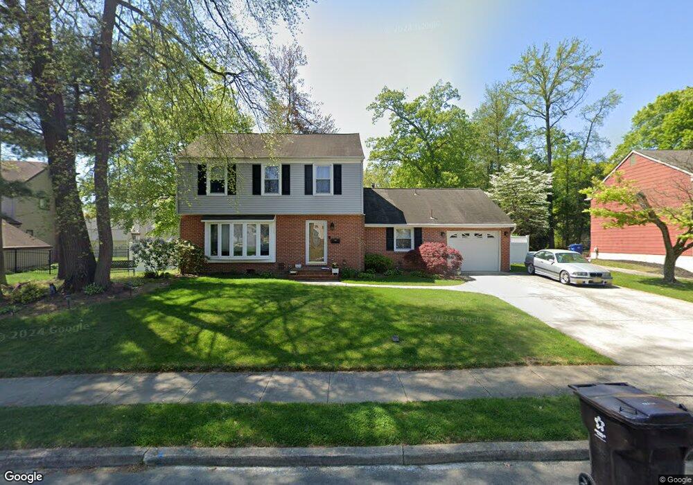
153 Antietam Rd Delran, NJ 08075
Swedes Run NeighborhoodEstimated Value: $343,787 - $479,000
--
Bed
--
Bath
1,600
Sq Ft
$274/Sq Ft
Est. Value
About This Home
This home is located at 153 Antietam Rd, Delran, NJ 08075 and is currently estimated at $438,447, approximately $274 per square foot. 153 Antietam Rd is a home located in Burlington County with nearby schools including Millbridge Elementary School, Delran Intermediate School, and Delran Middle School.
Ownership History
Date
Name
Owned For
Owner Type
Purchase Details
Closed on
May 26, 1999
Sold by
Cannistraci Anthony and Cannistraci Melissa
Bought by
Stoer Michael R and Stoer Lisa A
Current Estimated Value
Home Financials for this Owner
Home Financials are based on the most recent Mortgage that was taken out on this home.
Original Mortgage
$119,920
Outstanding Balance
$31,236
Interest Rate
6.9%
Mortgage Type
Purchase Money Mortgage
Estimated Equity
$407,211
Purchase Details
Closed on
Mar 14, 1994
Sold by
Witucki Frances L
Bought by
Cannistraci Anthony and Prince Melissa
Home Financials for this Owner
Home Financials are based on the most recent Mortgage that was taken out on this home.
Original Mortgage
$112,000
Interest Rate
6.93%
Mortgage Type
FHA
Create a Home Valuation Report for This Property
The Home Valuation Report is an in-depth analysis detailing your home's value as well as a comparison with similar homes in the area
Home Values in the Area
Average Home Value in this Area
Purchase History
| Date | Buyer | Sale Price | Title Company |
|---|---|---|---|
| Stoer Michael R | $149,900 | -- | |
| Cannistraci Anthony | $120,000 | -- |
Source: Public Records
Mortgage History
| Date | Status | Borrower | Loan Amount |
|---|---|---|---|
| Open | Stoer Michael R | $119,920 | |
| Previous Owner | Cannistraci Anthony | $112,000 |
Source: Public Records
Tax History Compared to Growth
Tax History
| Year | Tax Paid | Tax Assessment Tax Assessment Total Assessment is a certain percentage of the fair market value that is determined by local assessors to be the total taxable value of land and additions on the property. | Land | Improvement |
|---|---|---|---|---|
| 2025 | $8,135 | $204,600 | $65,000 | $139,600 |
| 2024 | $8,061 | $204,600 | $65,000 | $139,600 |
| 2023 | $8,061 | $204,600 | $65,000 | $139,600 |
| 2022 | $7,957 | $204,600 | $65,000 | $139,600 |
| 2021 | $7,373 | $204,600 | $65,000 | $139,600 |
| 2020 | $7,945 | $204,600 | $65,000 | $139,600 |
| 2019 | $7,871 | $204,600 | $65,000 | $139,600 |
| 2018 | $7,740 | $204,600 | $65,000 | $139,600 |
| 2017 | $7,617 | $204,600 | $65,000 | $139,600 |
| 2016 | $7,505 | $204,600 | $65,000 | $139,600 |
| 2015 | $7,380 | $204,600 | $65,000 | $139,600 |
| 2014 | $7,059 | $204,600 | $65,000 | $139,600 |
Source: Public Records
Map
Nearby Homes
- 142 Fox Chase Dr
- 164 Fox Chase Dr
- 347 Tom Brown Rd
- 110 Kathleen Ave
- 343 Tom Brown Rd
- 128 Dorado Dr
- 415 Bridgeboro Rd
- 4327 Bridgeboro Rd
- 139 Patricia Ave
- 228 Aqua Ln
- 53 Princeton Dr
- 31 Cornell Dr
- 60 Notre Dame Dr
- 43 Princeton Dr
- 7 Whitetail Ct
- 693 Garwood Rd
- 628 Windsock Way
- 29 Haines Mill Rd
- 2408 New Albany Rd
- 103 Congressional Ct
- 155 Antietam Rd
- 151 Antietam Rd
- 154 Oxford Rd
- 152 Oxford Rd
- 157 Antietam Rd
- 156 Oxford Rd
- 150 Antietam Rd
- 150 Oxford Rd
- 152 Antietam Rd
- 154 Antietam Rd
- 159 Antietam Rd
- 158 Oxford Rd
- 125 Windmoor Rd
- 123 Windmoor Rd
- 127 Windmoor Rd
- 120 Windmoor Rd
- 156 Antietam Rd
- 155 Oxford Rd
- 121 Windmoor Rd
- 129 Windmoor Rd