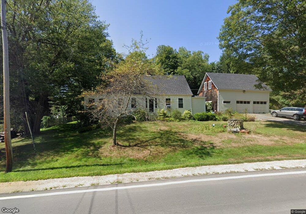
153 Moses Gerrish Farmer Rd Eliot, ME 03903
South Eliot NeighborhoodEstimated Value: $506,355 - $614,000
3
Beds
1
Bath
1,508
Sq Ft
$363/Sq Ft
Est. Value
About This Home
This home is located at 153 Moses Gerrish Farmer Rd, Eliot, ME 03903 and is currently estimated at $547,339, approximately $362 per square foot. 153 Moses Gerrish Farmer Rd is a home located in York County with nearby schools including Marshwood High School and Seacoast Waldorf School.
Ownership History
Date
Name
Owned For
Owner Type
Purchase Details
Closed on
Apr 29, 2005
Sold by
Kennedy Mary A and Kennedy John R
Bought by
Donovan Elizabeth A
Current Estimated Value
Home Financials for this Owner
Home Financials are based on the most recent Mortgage that was taken out on this home.
Original Mortgage
$43,900
Outstanding Balance
$23,051
Interest Rate
5.95%
Mortgage Type
Purchase Money Mortgage
Estimated Equity
$524,288
Create a Home Valuation Report for This Property
The Home Valuation Report is an in-depth analysis detailing your home's value as well as a comparison with similar homes in the area
Home Values in the Area
Average Home Value in this Area
Purchase History
| Date | Buyer | Sale Price | Title Company |
|---|---|---|---|
| Donovan Elizabeth A | -- | -- |
Source: Public Records
Mortgage History
| Date | Status | Borrower | Loan Amount |
|---|---|---|---|
| Open | Donovan Elizabeth A | $43,900 |
Source: Public Records
Tax History Compared to Growth
Tax History
| Year | Tax Paid | Tax Assessment Tax Assessment Total Assessment is a certain percentage of the fair market value that is determined by local assessors to be the total taxable value of land and additions on the property. | Land | Improvement |
|---|---|---|---|---|
| 2024 | $3,934 | $332,000 | $139,800 | $192,200 |
| 2023 | $3,903 | $318,600 | $133,400 | $185,200 |
| 2022 | $3,854 | $318,500 | $133,400 | $185,100 |
| 2021 | $3,769 | $302,900 | $122,700 | $180,200 |
| 2020 | $4,364 | $296,900 | $117,400 | $179,500 |
| 2019 | $1,001 | $262,600 | $117,400 | $145,200 |
| 2018 | $3,860 | $262,600 | $117,400 | $145,200 |
| 2017 | $3,755 | $262,600 | $117,400 | $145,200 |
| 2016 | $3,690 | $262,600 | $117,400 | $145,200 |
| 2015 | $3,662 | $261,600 | $117,400 | $144,200 |
| 2014 | $3,610 | $261,600 | $117,400 | $144,200 |
| 2013 | $3,445 | $261,600 | $117,400 | $144,200 |
Source: Public Records
Map
Nearby Homes
- 956 Main St
- 850 Main St
- 0 Franks Fort Island Unit 1631886
- 18 Shipping Ln
- 8 Caslyn Dr
- 35 Leach Rd
- 493 Main St
- 46 Littlebrook Ln
- 7 Fernald Rd
- 18 Governor Hill Rd
- 10 Shipwright Way
- 1708 State Rd
- 71 Shipwright Way
- 33 Little Bay Dr
- 27 Wentworth Terrace
- 18 Little Bay Dr
- 5 Spinney Way Unit 9
- SLIP 15 Little Bay Marina
- 0 Cote Dr
- 124 Spinnaker Way
- 161 Moses Gerrish Farmer Rd
- 147 Moses Gerrish Farmer Rd
- 156 Moses Gerrish Farmer Rd
- 149 Moses Gerrish Farmer Rd
- 160 Moses Gerrish Farmer Rd
- 144 Moses Gerrish Farmer Rd
- 0 Farmer Rd
- 16 Weston Ave
- 169 Moses Gerrish Farmer Rd
- 140 Moses Gerrish Farmer Rd
- 2 Stonewall Way
- 138 Moses Gerrish Farmer Rd
- 159 Moses Gerrish Farmer Rd
- 174 Moses Gerrish Farmer Rd
- 173 Moses Gerrish Farmer Rd
- 3 Stonewall Way
- 131 Moses Gerrish Farmer Rd
- 177 Moses Gerrish Farmer Rd
- 1289 State Rd
- 125 State Rd