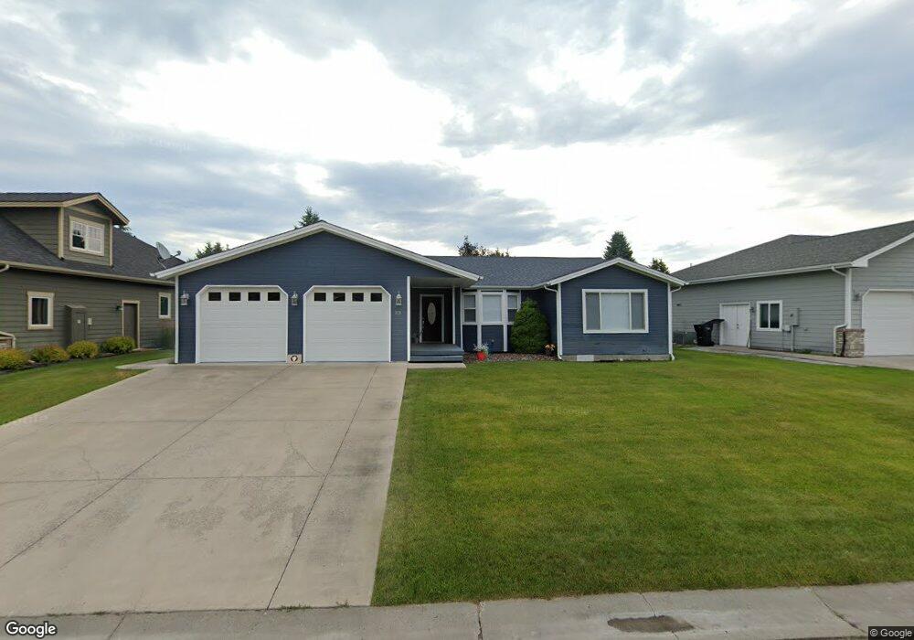
153 Palmer Dr Kalispell, MT 59901
Estimated Value: $544,000 - $615,000
4
Beds
3
Baths
1,912
Sq Ft
$302/Sq Ft
Est. Value
About This Home
This home is located at 153 Palmer Dr, Kalispell, MT 59901 and is currently estimated at $578,328, approximately $302 per square foot. 153 Palmer Dr is a home located in Flathead County with nearby schools including Edgerton School, Kalispell Middle School, and Glacier High School.
Ownership History
Date
Name
Owned For
Owner Type
Purchase Details
Closed on
Jul 14, 2020
Sold by
Perrins Jeffry T
Bought by
Perrins Joan T
Current Estimated Value
Purchase Details
Closed on
Feb 28, 2020
Sold by
Sharpe Chassidy T and Sharpe Travis M
Bought by
Perrins Jeffry T and Perrins Joan N
Home Financials for this Owner
Home Financials are based on the most recent Mortgage that was taken out on this home.
Original Mortgage
$252,000
Outstanding Balance
$223,603
Interest Rate
3.6%
Mortgage Type
New Conventional
Estimated Equity
$354,725
Purchase Details
Closed on
Aug 7, 2007
Sold by
Wardle Charles M
Bought by
Northern Lights Properties Llc
Create a Home Valuation Report for This Property
The Home Valuation Report is an in-depth analysis detailing your home's value as well as a comparison with similar homes in the area
Purchase History
| Date | Buyer | Sale Price | Title Company |
|---|---|---|---|
| Perrins Joan T | -- | None Available | |
| Perrins Jeffry T | -- | Fidelity National Title | |
| Northern Lights Properties Llc | -- | None Available |
Source: Public Records
Mortgage History
| Date | Status | Borrower | Loan Amount |
|---|---|---|---|
| Open | Perrins Jeffry T | $252,000 |
Source: Public Records
Tax History
| Year | Tax Paid | Tax Assessment Tax Assessment Total Assessment is a certain percentage of the fair market value that is determined by local assessors to be the total taxable value of land and additions on the property. | Land | Improvement |
|---|---|---|---|---|
| 2025 | $3,409 | $612,300 | $0 | $0 |
| 2024 | $3,690 | $473,800 | $0 | $0 |
| 2023 | $3,990 | $473,800 | $0 | $0 |
| 2022 | $3,749 | $373,200 | $0 | $0 |
| 2021 | $4,016 | $373,200 | $0 | $0 |
| 2020 | $3,754 | $315,500 | $0 | $0 |
| 2019 | $3,762 | $315,500 | $0 | $0 |
| 2018 | $3,966 | $320,300 | $0 | $0 |
| 2017 | $3,981 | $320,300 | $0 | $0 |
| 2016 | $3,283 | $286,400 | $0 | $0 |
| 2015 | $3,286 | $286,400 | $0 | $0 |
| 2014 | $3,085 | $161,120 | $0 | $0 |
Source: Public Records
Map
Nearby Homes
- 203 W Nicklaus Ave
- 185 Palmer Dr
- 168 W Nicklaus Ave
- 116 Trevino Dr
- 218 E Nicklaus Ave
- 217 E Nicklaus Ave
- 284 W Nicklaus Ave
- 227 E Nicklaus Ave
- 114 W Nicklaus Ave
- 269 W Nicklaus Ave
- 122 Granary Ridge Dr
- 2196 Mission Trail
- 63 Village Loop Unit 3
- 63 Village Loop Unit 1
- 71 Glacier Cir
- 11 White Bark
- 102 Buffalo Square Ct
- 44 Glacier Cir
- 38 Glacier Cir
- 25 Glacier Cir
Your Personal Tour Guide
Ask me questions while you tour the home.