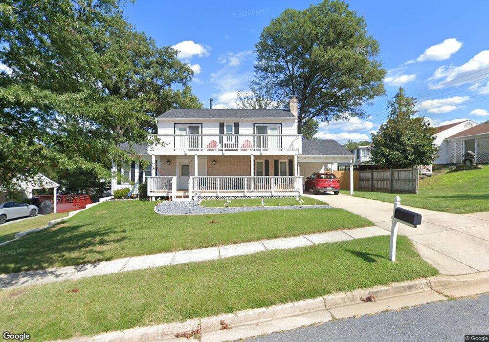
15303 Bounds Ave Laurel, MD 20707
West Laurel NeighborhoodEstimated Value: $443,099 - $555,000
--
Bed
3
Baths
1,624
Sq Ft
$314/Sq Ft
Est. Value
About This Home
This home is located at 15303 Bounds Ave, Laurel, MD 20707 and is currently estimated at $510,525, approximately $314 per square foot. 15303 Bounds Ave is a home located in Prince George's County with nearby schools including Bond Mill Elementary, Martin Luther King Jr. Middle School, and Laurel High School.
Ownership History
Date
Name
Owned For
Owner Type
Purchase Details
Closed on
Sep 18, 2020
Sold by
Renoud Beverly L and Renoud Ronald Todd
Bought by
Renoud Ronald Todd
Current Estimated Value
Home Financials for this Owner
Home Financials are based on the most recent Mortgage that was taken out on this home.
Original Mortgage
$319,176
Outstanding Balance
$282,722
Interest Rate
2.8%
Mortgage Type
New Conventional
Estimated Equity
$227,803
Purchase Details
Closed on
Sep 8, 1969
Sold by
Silkor Dev Corp
Bought by
Renoud Ronald R and Renoud Beverly L
Create a Home Valuation Report for This Property
The Home Valuation Report is an in-depth analysis detailing your home's value as well as a comparison with similar homes in the area
Home Values in the Area
Average Home Value in this Area
Purchase History
| Date | Buyer | Sale Price | Title Company |
|---|---|---|---|
| Renoud Ronald Todd | -- | Orange Coast Lender Services | |
| Renoud Ronald R | $31,500 | -- |
Source: Public Records
Mortgage History
| Date | Status | Borrower | Loan Amount |
|---|---|---|---|
| Open | Renoud Ronald Todd | $319,176 |
Source: Public Records
Tax History Compared to Growth
Tax History
| Year | Tax Paid | Tax Assessment Tax Assessment Total Assessment is a certain percentage of the fair market value that is determined by local assessors to be the total taxable value of land and additions on the property. | Land | Improvement |
|---|---|---|---|---|
| 2025 | $5,008 | $410,400 | $141,300 | $269,100 |
| 2024 | $5,008 | $383,533 | $0 | $0 |
| 2023 | $4,797 | $356,667 | $0 | $0 |
| 2022 | $4,539 | $329,800 | $101,300 | $228,500 |
| 2021 | $4,386 | $323,200 | $0 | $0 |
| 2020 | $4,330 | $316,600 | $0 | $0 |
| 2019 | $4,439 | $310,000 | $100,600 | $209,400 |
| 2018 | $4,384 | $295,033 | $0 | $0 |
| 2017 | $3,898 | $280,067 | $0 | $0 |
| 2016 | -- | $265,100 | $0 | $0 |
| 2015 | $3,520 | $265,100 | $0 | $0 |
| 2014 | $3,520 | $265,100 | $0 | $0 |
Source: Public Records
Map
Nearby Homes
- 6403 Park Hall Dr
- 15622 Bond Mill Rd
- 6802 Niles Dr
- 6918 Scotch Dr
- 6003 Windham Rd
- 1027 Overlook Way
- 1106 Overlook Way
- 1023 Flester Ln
- 1013 Highpoint Trail
- 7019 Fitzpatrick Dr
- 7312 Archsine Ln
- 6703 Bonnett Ct
- 7019 Redmiles Rd
- 7403 Berryleaf Dr
- 15712 Dorset Rd Unit T3
- 15020 Cherrywood Dr
- 7105 Split Rail Ln
- 15708 Dorset Rd Unit 203
- 15708 Dorset Rd Unit 304
- 7419 Berryleaf Dr
- 15305 Bounds Ave
- 6406 Sandy Spring Rd
- 6408 Sandy Spring Rd
- 15400 Calshot Ct
- 15307 Bounds Ave
- 6410 Sandy Spring Rd
- 15304 Bounds Ave
- 15302 Bounds Ave
- 15401 Calshot Ct
- 15309 Bounds Ave
- 6500 Sandy Spring Rd
- 15402 Calshot Ct
- 15308 Bounds Ave
- 15401 Bounds Ave
- 15403 Calshot Ct
- 6502 Sandy Spring Rd
- 6502 Old Sandy Spring Rd
- 6405 Orly Ln
- 15404 Calshot Ct
- 15403 Bounds Ave