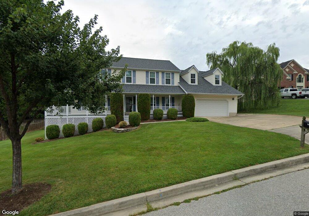
15305 Walker Branch Ct Laurel, MD 20707
West Laurel NeighborhoodEstimated Value: $560,000 - $727,000
Studio
3
Baths
2,784
Sq Ft
$226/Sq Ft
Est. Value
About This Home
This home is located at 15305 Walker Branch Ct, Laurel, MD 20707 and is currently estimated at $628,890, approximately $225 per square foot. 15305 Walker Branch Ct is a home located in Prince George's County with nearby schools including Bond Mill Elementary, Martin Luther King Jr. Middle School, and Laurel High School.
Ownership History
Date
Name
Owned For
Owner Type
Purchase Details
Closed on
Jul 10, 2007
Sold by
Baltz John E
Bought by
Baltzrebecca A Revocable Trust
Current Estimated Value
Purchase Details
Closed on
Jun 12, 2007
Sold by
Baltz John E
Bought by
Baltzrebecca A Revocable Trust
Purchase Details
Closed on
Apr 30, 1996
Sold by
New Concept Homes Inc
Bought by
Baltz John E and Baltz Rebecca A
Create a Home Valuation Report for This Property
The Home Valuation Report is an in-depth analysis detailing your home's value as well as a comparison with similar homes in the area
Home Values in the Area
Average Home Value in this Area
Purchase History
| Date | Buyer | Sale Price | Title Company |
|---|---|---|---|
| Baltzrebecca A Revocable Trust | -- | -- | |
| Baltzrebecca A Revocable Trust | -- | -- | |
| Baltz John E | $70,000 | -- |
Source: Public Records
Tax History
| Year | Tax Paid | Tax Assessment Tax Assessment Total Assessment is a certain percentage of the fair market value that is determined by local assessors to be the total taxable value of land and additions on the property. | Land | Improvement |
|---|---|---|---|---|
| 2025 | $7,087 | $559,400 | $143,300 | $416,100 |
| 2024 | $7,087 | $538,000 | -- | -- |
| 2023 | $6,863 | $516,600 | $0 | $0 |
| 2022 | $6,571 | $495,200 | $103,300 | $391,900 |
| 2021 | $6,338 | $484,100 | $0 | $0 |
| 2020 | $6,248 | $473,000 | $0 | $0 |
| 2019 | $6,125 | $461,900 | $101,600 | $360,300 |
| 2018 | $5,995 | $456,200 | $0 | $0 |
| 2017 | $6,731 | $450,500 | $0 | $0 |
| 2016 | -- | $444,800 | $0 | $0 |
| 2015 | $5,898 | $428,667 | $0 | $0 |
| 2014 | $5,898 | $412,533 | $0 | $0 |
Source: Public Records
Map
Nearby Homes
- 6918 Scotch Dr
- 7002 Scotch Dr
- 7004 Fitzpatrick Dr
- 6003 Windham Rd
- 7019 Fitzpatrick Dr
- 7019 Redmiles Rd
- 1012 Flester Ln
- 1016 Flester Ln
- 1027 Overlook Way
- 14005 Barkham Ct
- 1023 Flester Ln
- 15712 Dorset Rd Unit 104
- 1024 Flester Ln
- 1106 Overlook Way
- 1023 Highpoint Trail
- 14717 Exbury Ln
- 15708 Dorset Rd Unit 202
- 15706 Dorset Rd Unit 102
- 15603 Dorset Rd Unit 101
- 16140 Kenny Rd
- 15303 Walker Branch Ct
- 15307 Walker Branch Ct
- 15404 Misty Pine Rd
- 15301 Walker Branch Ct
- 15306 Walker Branch Ct
- 15309 Walker Branch Ct
- 15308 Walker Branch Ct
- 15402 Misty Pine Rd
- 6606 Sandy Spring Rd
- 15304 Walker Branch Ct
- 6604 Sandy Spring Rd
- 6601 Cedar Spring Ct
- 15406 Misty Pine Rd
- 6505 Walker Branch Dr
- 6608 Sandy Spring Rd
- 6600 Sandy Spring Rd
- 6510 Sandy Spring Rd
- 15400 Misty Pine Rd
- 6510 Old Sandy Spring Rd
- 15413 Calshot Ct
Your Personal Tour Guide
Ask me questions while you tour the home.