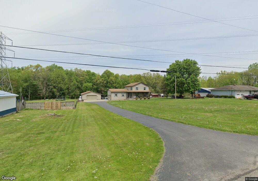
1531 Payne St Mineral Ridge, OH 44440
Estimated Value: $285,000 - $347,000
3
Beds
3
Baths
1,912
Sq Ft
$165/Sq Ft
Est. Value
About This Home
This home is located at 1531 Payne St, Mineral Ridge, OH 44440 and is currently estimated at $314,658, approximately $164 per square foot. 1531 Payne St is a home located in Trumbull County with nearby schools including Seaborn Elementary School, Mineral Ridge High School, and Niles Preparatory Academy.
Ownership History
Date
Name
Owned For
Owner Type
Purchase Details
Closed on
Nov 14, 2023
Sold by
Dawson James R
Bought by
Humansky Steven J and Humansky Amber L
Current Estimated Value
Purchase Details
Closed on
Sep 21, 2021
Sold by
Dawson James R and Remias Ashley M
Bought by
Dawson James R
Home Financials for this Owner
Home Financials are based on the most recent Mortgage that was taken out on this home.
Original Mortgage
$150,000
Interest Rate
2.1%
Mortgage Type
New Conventional
Purchase Details
Closed on
Aug 21, 2012
Sold by
Ladd Michael A
Bought by
Dawson James R and Remias Ashley M
Home Financials for this Owner
Home Financials are based on the most recent Mortgage that was taken out on this home.
Original Mortgage
$136,800
Interest Rate
3.66%
Mortgage Type
New Conventional
Purchase Details
Closed on
Apr 12, 1994
Sold by
Ladd Michael A
Bought by
Debra Ladd
Purchase Details
Closed on
Jan 1, 1990
Bought by
Michael A Ladd
Create a Home Valuation Report for This Property
The Home Valuation Report is an in-depth analysis detailing your home's value as well as a comparison with similar homes in the area
Home Values in the Area
Average Home Value in this Area
Purchase History
| Date | Buyer | Sale Price | Title Company |
|---|---|---|---|
| Humansky Steven J | $275,000 | None Listed On Document | |
| Dawson James R | -- | Boston National Title Agency | |
| Dawson James R | -- | None Available | |
| Debra Ladd | -- | -- | |
| Michael A Ladd | -- | -- |
Source: Public Records
Mortgage History
| Date | Status | Borrower | Loan Amount |
|---|---|---|---|
| Previous Owner | Dawson James R | $150,000 | |
| Previous Owner | Dawson James R | $136,800 |
Source: Public Records
Tax History Compared to Growth
Tax History
| Year | Tax Paid | Tax Assessment Tax Assessment Total Assessment is a certain percentage of the fair market value that is determined by local assessors to be the total taxable value of land and additions on the property. | Land | Improvement |
|---|---|---|---|---|
| 2024 | $3,802 | $78,580 | $7,250 | $71,330 |
| 2023 | $3,802 | $78,580 | $7,250 | $71,330 |
| 2022 | $2,924 | $57,480 | $7,250 | $50,230 |
| 2021 | $2,923 | $57,480 | $7,250 | $50,230 |
| 2020 | $2,929 | $57,480 | $7,250 | $50,230 |
| 2019 | $2,990 | $54,640 | $7,250 | $47,390 |
| 2018 | $2,977 | $54,640 | $7,250 | $47,390 |
| 2017 | $2,974 | $54,640 | $7,250 | $47,390 |
| 2016 | $2,860 | $50,160 | $7,250 | $42,910 |
| 2015 | $2,856 | $50,160 | $7,250 | $42,910 |
| 2014 | $2,865 | $50,160 | $7,250 | $42,910 |
| 2013 | $2,817 | $50,160 | $7,250 | $42,910 |
Source: Public Records
Map
Nearby Homes
- 3328 Main St
- 3474 S Main St
- 3440 Lakeside Dr
- 1721 Ohltown McDonald Rd
- 1218 Ohltown McDonald Rd
- 1684 Morris St
- 3872 Main St
- 1676 Rosalyn Cir
- 1458 Lincoln Ave
- 3907 Edwards St
- 2957 Greenfield Ave
- 2169 Salt Springs Rd
- 1445 E County Line Rd
- 1757 E County Line Rd
- 21 E Liberty St
- 561 Ward Ave
- 6 Omalia Dr
- 3050 Trumbull Ave
- 0 W Webb Rd
- 6360 Meander Glen Dr
- 1543 Payne St
- 1517 Payne St
- 1481 Payne St
- 1530 Payne St
- 1518 Payne St
- 1485 Payne St
- 1504 Payne St
- 1544 Payne St
- 1489 Payne St
- 1494 Payne St
- 1463 Payne St
- 1558 Payne St
- 1486 Payne St
- 1500 Ohltown McDonald Rd
- 1546 Ohltown McDonald Rd
- 1461 Payne St
- 1453 Payne St
- 1596 Salt Springs Rd
- 1590 Salt Springs Rd
- 1445 Payne St