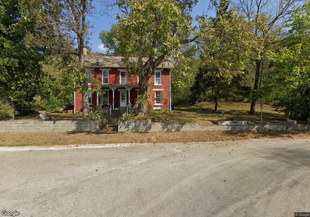
15310 Mcafee Rd Athens, OH 45701
Estimated Value: $198,000 - $290,000
4
Beds
2
Baths
2,480
Sq Ft
$96/Sq Ft
Est. Value
About This Home
This home is located at 15310 Mcafee Rd, Athens, OH 45701 and is currently estimated at $237,715, approximately $95 per square foot. 15310 Mcafee Rd is a home with nearby schools including Amesville Elementary School, Coolville Elementary School, and Federal Hocking Middle School.
Ownership History
Date
Name
Owned For
Owner Type
Purchase Details
Closed on
Nov 3, 2021
Sold by
Strode Kathy L
Bought by
Shultz Peter W and Berardi Katherine R
Current Estimated Value
Home Financials for this Owner
Home Financials are based on the most recent Mortgage that was taken out on this home.
Original Mortgage
$140,000
Outstanding Balance
$128,321
Interest Rate
3.01%
Mortgage Type
New Conventional
Estimated Equity
$109,394
Create a Home Valuation Report for This Property
The Home Valuation Report is an in-depth analysis detailing your home's value as well as a comparison with similar homes in the area
Home Values in the Area
Average Home Value in this Area
Purchase History
| Date | Buyer | Sale Price | Title Company |
|---|---|---|---|
| Shultz Peter W | $160,000 | Secure Title |
Source: Public Records
Mortgage History
| Date | Status | Borrower | Loan Amount |
|---|---|---|---|
| Open | Shultz Peter W | $140,000 |
Source: Public Records
Tax History Compared to Growth
Tax History
| Year | Tax Paid | Tax Assessment Tax Assessment Total Assessment is a certain percentage of the fair market value that is determined by local assessors to be the total taxable value of land and additions on the property. | Land | Improvement |
|---|---|---|---|---|
| 2024 | $1,996 | $43,550 | $13,250 | $30,300 |
| 2023 | $1,027 | $43,550 | $13,250 | $30,300 |
| 2022 | $1,599 | $34,430 | $10,190 | $24,240 |
| 2021 | $1,632 | $34,430 | $10,190 | $24,240 |
| 2020 | $1,551 | $34,430 | $10,190 | $24,240 |
| 2019 | $1,491 | $31,950 | $8,450 | $23,500 |
| 2018 | $1,643 | $35,410 | $8,450 | $26,960 |
| 2017 | $2,226 | $35,410 | $8,450 | $26,960 |
| 2016 | $1,514 | $31,610 | $7,680 | $23,930 |
| 2015 | -- | $31,610 | $7,680 | $23,930 |
Source: Public Records
Map
Nearby Homes
- 14240 Della Dr
- 16749 Mush Run Rd
- 17777 Mush Run Rd
- 14050 Rocky Point Rd
- 15791 Willow Creek Rd
- 6545 Long Run Rd
- 14 Euclid Dr
- 0 E Copeland Rd Unit 2434030
- 44 Strathmore Blvd
- 11711 Peach Ridge Rd
- 11845 N Peach Ridge
- 12 Mc Guffey Ln
- 12 McGuffey Ln
- 199 Longview Heights Rd
- 18999 River
- 273 E State St
- 0 Strouds Run Unit 2433166
- 0 Nottingham Dr
- 5 Applegate Dr
- 99 Mulligan Rd
- 15500 Mcafee Rd
- 15174 Harmony Rd
- 15165 Harmony Rd
- 15019 Harmony Rd
- 15650 Mcafee Rd
- 15115 Harmony Rd
- 15225 S Canaan Rd
- 15171 S Canaan Rd
- 15700 Mcafee Rd
- 15267 S Canaan Rd
- 9208 State Route 690
- 9452 State Route 690
- 9366 State Route 690
- 15445 S Canaan Rd
- 9626 State Route 690
- 9819 State Route 690
- 15571 S Canaan Rd