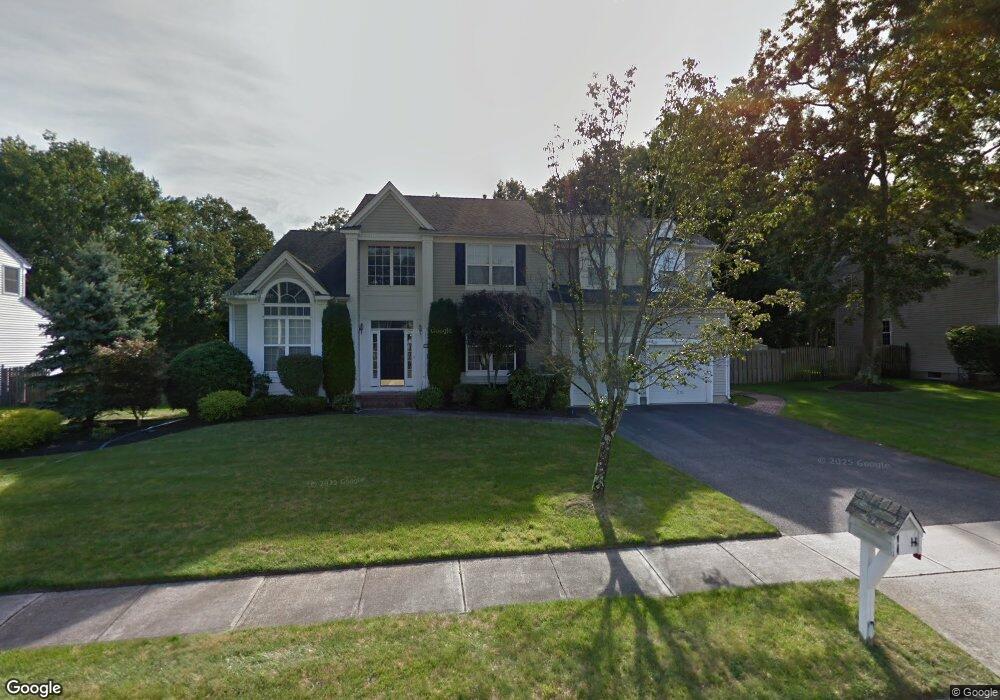
1533 Forrest Trail Cir Toms River, NJ 08753
Estimated Value: $883,191 - $958,000
5
Beds
3
Baths
4,300
Sq Ft
$211/Sq Ft
Est. Value
About This Home
This home is located at 1533 Forrest Trail Cir, Toms River, NJ 08753 and is currently estimated at $905,548, approximately $210 per square foot. 1533 Forrest Trail Cir is a home located in Ocean County with nearby schools including St Joseph Grade School and Donovan Catholic High School.
Ownership History
Date
Name
Owned For
Owner Type
Purchase Details
Closed on
Oct 28, 1997
Sold by
D R Horton Inc
Bought by
Honschke Neil D and Honschke Leslie S
Current Estimated Value
Home Financials for this Owner
Home Financials are based on the most recent Mortgage that was taken out on this home.
Original Mortgage
$199,500
Outstanding Balance
$32,481
Interest Rate
7.19%
Estimated Equity
$873,067
Create a Home Valuation Report for This Property
The Home Valuation Report is an in-depth analysis detailing your home's value as well as a comparison with similar homes in the area
Home Values in the Area
Average Home Value in this Area
Purchase History
| Date | Buyer | Sale Price | Title Company |
|---|---|---|---|
| Honschke Neil D | $249,490 | -- |
Source: Public Records
Mortgage History
| Date | Status | Borrower | Loan Amount |
|---|---|---|---|
| Open | Honschke Neil D | $199,500 |
Source: Public Records
Tax History Compared to Growth
Tax History
| Year | Tax Paid | Tax Assessment Tax Assessment Total Assessment is a certain percentage of the fair market value that is determined by local assessors to be the total taxable value of land and additions on the property. | Land | Improvement |
|---|---|---|---|---|
| 2025 | $11,883 | $652,200 | $170,000 | $482,200 |
| 2024 | $11,196 | $652,200 | $170,000 | $482,200 |
| 2023 | $10,789 | $646,800 | $170,000 | $476,800 |
| 2022 | $10,789 | $646,800 | $170,000 | $476,800 |
| 2021 | $10,831 | $443,000 | $106,000 | $337,000 |
| 2020 | $10,933 | $439,600 | $106,000 | $333,600 |
| 2019 | $10,458 | $439,600 | $106,000 | $333,600 |
| 2018 | $10,353 | $439,600 | $106,000 | $333,600 |
| 2017 | $10,282 | $439,600 | $106,000 | $333,600 |
| 2016 | $10,040 | $439,600 | $106,000 | $333,600 |
| 2015 | $9,680 | $439,600 | $106,000 | $333,600 |
| 2014 | $9,201 | $439,600 | $106,000 | $333,600 |
Source: Public Records
Map
Nearby Homes
- 25 Bristol Ct
- 133 London Ct
- 1261 Indian Hill Rd
- 1388 White Spruce Dr
- 27 Squire Ct
- 11 Yorkshire Dr
- 991 Stamler Dr
- 987 Grace Dr
- 1656 N Bay Ave
- 120 Shenandoah Blvd
- 4 Harpers Ferry Rd
- 528 Eagle Point Dr
- 1548 N Bay Ave
- 146 Shenandoah Blvd
- 1528 Whitty Pine Ct
- 2430-2438 Church Rd
- 1623 Church Rd
- 1925 Mount Carmel Blvd
- 1874 Hidden Brook Ct
- 1214 Waters Edge Dr Unit 14
- 1529 Forrest Trail Cir
- 1537 Forrest Trail Cir
- 1534 Forrest Trail Cir
- 1525 Forrest Trail Cir
- 1541 Forrest Trail Cir
- 1542 Forrest Trail Cir
- 1250 Black Birch Ct
- 4 Liverpool Ct
- 1521 Forrest Trail Cir
- 1255 Black Birch Ct
- 1545 Forrest Trail Cir
- 7 Liverpool Ct
- 1550 Forrest Trail Cir
- 8 Liverpool Ct
- 1520 Forrest Trail Cir
- 1549 Forrest Trail Cir
- 11 Liverpool Ct
- 1517 Forrest Trail Cir
- 1254 Black Birch Ct
- 1259 Black Birch Ct