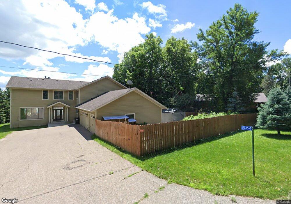
15354 Crestland Rd Paynesville, MN 56362
Estimated Value: $716,000 - $910,542
3
Beds
3
Baths
3,403
Sq Ft
$243/Sq Ft
Est. Value
About This Home
This home is located at 15354 Crestland Rd, Paynesville, MN 56362 and is currently estimated at $827,514, approximately $243 per square foot. 15354 Crestland Rd is a home located in Stearns County with nearby schools including Paynesville Elementary School, Paynesville Middle School, and Paynesville Area High School.
Ownership History
Date
Name
Owned For
Owner Type
Purchase Details
Closed on
Oct 7, 2021
Sold by
Nadwodney Dale Dale
Bought by
Wallington William William
Current Estimated Value
Home Financials for this Owner
Home Financials are based on the most recent Mortgage that was taken out on this home.
Original Mortgage
$684,000
Outstanding Balance
$625,450
Interest Rate
2.99%
Estimated Equity
$202,064
Purchase Details
Closed on
Aug 19, 2005
Sold by
Biedlersusan Trust
Bought by
Nadwodny Dale
Create a Home Valuation Report for This Property
The Home Valuation Report is an in-depth analysis detailing your home's value as well as a comparison with similar homes in the area
Home Values in the Area
Average Home Value in this Area
Purchase History
| Date | Buyer | Sale Price | Title Company |
|---|---|---|---|
| Wallington William William | $760,000 | -- | |
| Nadwodny Dale | $630,000 | -- |
Source: Public Records
Mortgage History
| Date | Status | Borrower | Loan Amount |
|---|---|---|---|
| Open | Wallington William William | $684,000 | |
| Closed | Wallington William William | -- |
Source: Public Records
Tax History Compared to Growth
Tax History
| Year | Tax Paid | Tax Assessment Tax Assessment Total Assessment is a certain percentage of the fair market value that is determined by local assessors to be the total taxable value of land and additions on the property. | Land | Improvement |
|---|---|---|---|---|
| 2025 | $6,628 | $815,000 | $267,600 | $547,400 |
| 2024 | $7,428 | $815,000 | $267,600 | $547,400 |
| 2023 | $7,008 | $800,000 | $259,700 | $540,300 |
| 2022 | $5,612 | $586,100 | $206,000 | $380,100 |
| 2021 | $5,774 | $586,100 | $206,000 | $380,100 |
| 2020 | $5,884 | $543,100 | $206,000 | $337,100 |
| 2019 | $5,668 | $536,100 | $206,000 | $330,100 |
| 2018 | $5,514 | $517,400 | $210,500 | $306,900 |
Source: Public Records
Map
Nearby Homes
- 28780 Clarence Ct
- 28726 Clarence Ct
- 28707 Clarence Ct
- 28653 Clarence Ct
- 28413 Cherrywood Rd
- 28621 Clarence Ct
- 28401 Cherrywood Rd
- 28642 Clarence Ct
- 15889 Old Lake Rd
- 15976 Cushing Rd
- 28418 Cherrywood Rd
- 28630 Clarence Ct
- 14855 Linden Hill Rd
- 27798 Stonegate Rd
- 27795 Stonegate Rd
- 27763 Stonegate Rd
- 27755 Stonegate Rd
- 14856 Old Lake Rd
- 27822 Stonegate Rd
- 27829 Stonegate Rd
- 15332 Crestland Rd
- 15308 Crestland Rd
- 15376 Crestland Rd
- 29362 Crest Ridge Rd
- 29398 Casswood Rd
- 15284 Crestland Rd
- 15266 Crestland Rd
- 15263 Crestland Rd
- 15333 Crestland Rd
- 29361 Crest Ridge Rd
- 29434 Pelican Ct
- 15262 Crestland Rd
- 29383 Crest Ridge Rd
- 29427 Crest Ridge Rd
- 29436 Pelican Ct
- 15458 Casswood Rd
- 29438 Pelican Ct
- 29447 Casswood Rd
- 29451 Crest Ridge Rd
- 15452 Cardinal Ct