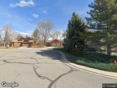
1536 Euclid Cir Lafayette, CO 80026
Estimated Value: $742,000 - $807,000
3
Beds
3
Baths
1,700
Sq Ft
$464/Sq Ft
Est. Value
About This Home
This home is located at 1536 Euclid Cir, Lafayette, CO 80026 and is currently estimated at $788,260, approximately $463 per square foot. 1536 Euclid Cir is a home located in Boulder County with nearby schools including Lafayette Elementary School, Angevine Middle School, and Centaurus High School.
Ownership History
Date
Name
Owned For
Owner Type
Purchase Details
Closed on
Jun 30, 1986
Bought by
Trumbo David W and Trumbo Vicki L
Current Estimated Value
Purchase Details
Closed on
Jul 11, 1984
Bought by
Trumbo David W and Trumbo Vicki L
Purchase Details
Closed on
Sep 1, 1983
Bought by
Trumbo David W and Trumbo Vicki L
Create a Home Valuation Report for This Property
The Home Valuation Report is an in-depth analysis detailing your home's value as well as a comparison with similar homes in the area
Home Values in the Area
Average Home Value in this Area
Purchase History
| Date | Buyer | Sale Price | Title Company |
|---|---|---|---|
| Trumbo David W | $123,500 | -- | |
| Trumbo David W | $93,000 | -- | |
| Trumbo David W | -- | -- |
Source: Public Records
Mortgage History
| Date | Status | Borrower | Loan Amount |
|---|---|---|---|
| Open | Trumbo Vicki L | $111,826 | |
| Closed | Trumbo Vicki L | $50,000 | |
| Closed | Trumbo David W | $50,000 | |
| Closed | Trumbo David W | $171,690 | |
| Closed | Trumbo David W | $178,570 | |
| Closed | Trumbo Vicki L | $52,250 | |
| Closed | Trumbo David W | $100,000 | |
| Closed | Trumbo David W | $200,000 | |
| Closed | Trumbo David W | $161,400 | |
| Closed | Trumbo Vicki L | $70,900 |
Source: Public Records
Tax History Compared to Growth
Tax History
| Year | Tax Paid | Tax Assessment Tax Assessment Total Assessment is a certain percentage of the fair market value that is determined by local assessors to be the total taxable value of land and additions on the property. | Land | Improvement |
|---|---|---|---|---|
| 2024 | $3,915 | $49,063 | $20,388 | $28,675 |
| 2023 | $3,848 | $50,880 | $20,375 | $34,190 |
| 2022 | $3,122 | $40,185 | $15,902 | $24,283 |
| 2021 | $3,088 | $41,341 | $16,359 | $24,982 |
| 2020 | $2,816 | $37,967 | $13,299 | $24,668 |
| 2019 | $2,778 | $37,967 | $13,299 | $24,668 |
| 2018 | $2,345 | $32,882 | $12,312 | $20,570 |
| 2017 | $2,283 | $36,354 | $13,612 | $22,742 |
| 2016 | $2,247 | $32,429 | $10,826 | $21,603 |
| 2015 | $2,105 | $26,626 | $7,005 | $19,621 |
| 2014 | $1,614 | $26,626 | $7,005 | $19,621 |
Source: Public Records
Map
Nearby Homes
- 1809 Keel Ct
- 1806 Blue Star Ln
- 1998 Foxtail Ln Unit B
- 1833 Sweet Clover Ln
- 1585 Hecla Way Unit 304
- 1585 Hecla Way Unit 201
- 2275 Schooner St
- 1996 Clipper Dr
- 2019 Clipper Dr
- 1805 Chalcis Dr Unit E
- 1356 Golden Eagle Way
- 1308 Snowberry Ln Unit 303
- 1308 Snowberry Ln Unit 301
- 1316 Snowberry Ln Unit 101
- 1304 Snowberry Ln Unit 103
- 1304 Snowberry Ln Unit 204
- 124 High Country Trail
- 2017 N Fork Dr
- 2069 N Fork Dr
- 2325 Glacier Ct
- 1536 Euclid Cir
- 1538 Euclid Cir
- 1534 Euclid Cir
- 798 Victoria Ct
- 782 Victoria Ct
- 1542 Euclid Cir
- 1540 Euclid Cir
- 1532 Euclid Cir
- 787 Crystal Ct
- 797 Crystal Ct
- 799 Victoria Ct
- 766 Victoria Ct
- 1530 Euclid Cir
- 773 Crystal Ct
- 1537 Euclid Cir
- 785 Victoria Ct
- 794 Crystal Ct
- 1544 Euclid Cir
- 1539 Euclid Cir
- 750 Victoria Ct
