Estimated Value: $204,000 - $271,000
3
Beds
2
Baths
1,350
Sq Ft
$175/Sq Ft
Est. Value
About This Home
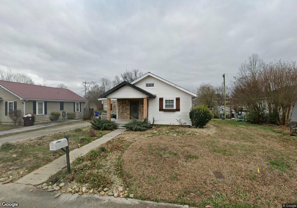
This home is located at 154 E Franklin St, Alcoa, TN 37701 and is currently estimated at $235,956, approximately $174 per square foot. 154 E Franklin St is a home located in Blount County with nearby schools including Alcoa Elementary School, Alcoa Middle School, and Alcoa High School.
Ownership History
Date
Name
Owned For
Owner Type
Purchase Details
Closed on
Dec 9, 2017
Sold by
Busby Dustin
Bought by
Busby Stephnie and Knapp Charmaine
Current Estimated Value
Purchase Details
Closed on
Aug 22, 2008
Sold by
Murray Mark
Bought by
Busby Dustin
Home Financials for this Owner
Home Financials are based on the most recent Mortgage that was taken out on this home.
Original Mortgage
$101,658
Interest Rate
6.61%
Purchase Details
Closed on
Sep 14, 2007
Sold by
Toney Doyle K
Bought by
Murray Mark
Purchase Details
Closed on
Mar 28, 1950
Bought by
Miller Ralph and Miller Emma
Create a Home Valuation Report for This Property
The Home Valuation Report is an in-depth analysis detailing your home's value as well as a comparison with similar homes in the area
Home Values in the Area
Average Home Value in this Area
Purchase History
| Date | Buyer | Sale Price | Title Company |
|---|---|---|---|
| Busby Stephnie | $90,545 | -- | |
| Busby Dustin | $103,000 | -- | |
| Murray Mark | $55,000 | -- | |
| Miller Ralph | -- | -- |
Source: Public Records
Mortgage History
| Date | Status | Borrower | Loan Amount |
|---|---|---|---|
| Previous Owner | Miller Ralph | $101,658 |
Source: Public Records
Tax History
| Year | Tax Paid | Tax Assessment Tax Assessment Total Assessment is a certain percentage of the fair market value that is determined by local assessors to be the total taxable value of land and additions on the property. | Land | Improvement |
|---|---|---|---|---|
| 2025 | -- | $45,950 | $7,500 | $38,450 |
| 2024 | -- | $45,950 | $7,500 | $38,450 |
| 2023 | $1,508 | $45,950 | $7,500 | $38,450 |
| 2022 | $1,101 | $23,225 | $3,000 | $20,225 |
| 2021 | $1,101 | $23,225 | $3,000 | $20,225 |
| 2020 | $1,101 | $23,225 | $3,000 | $20,225 |
| 2019 | $1,101 | $23,225 | $3,000 | $20,225 |
| 2018 | $978 | $22,075 | $2,250 | $19,825 |
| 2017 | $978 | $22,075 | $2,250 | $19,825 |
| 2016 | $978 | $22,075 | $2,250 | $19,825 |
| 2015 | $907 | $22,075 | $2,250 | $19,825 |
| 2014 | $961 | $22,075 | $2,250 | $19,825 |
| 2013 | $961 | $23,375 | $0 | $0 |
Source: Public Records
Map
Nearby Homes
- 254 W Newcomen St
- 1538 Tsuga Dr
- 646 Kirkwell Dr
- 1321 Nobel St Unit E
- 0 N Wright Rd
- 1240 N Wright Rd
- 1413 Perkins St
- 1631 Springbrook Rd
- 1826 Peppertree Dr
- 1330 Mountain Quail Cir
- 922 Poplar St
- 1450 Dalton St
- 471 E Lincoln Rd
- 869 Cedar St
- 614 Wright Rd
- 966 Poplar St
- 602 Mcginley St
- 304 W Lincoln Rd
- 1539 Boyle St
- 971 Maple St
- 148 E Franklin St
- 159 E Bell St
- 166 E Franklin St
- 142 E Franklin St
- 169 E Bell St
- 153 E Bell St
- 173 E Bell St
- 149 E Bell St
- 172 E Franklin St
- 136 E Franklin St
- 179 E Bell St
- 143 E Bell St
- 130 E Franklin St
- 875 Morse St
- 881 Morse St
- 137 E Bell St
- 869 Morse St
- 166 E Bell St
- 158 E Bell St
- 152 E Bell St
Your Personal Tour Guide
Ask me questions while you tour the home.