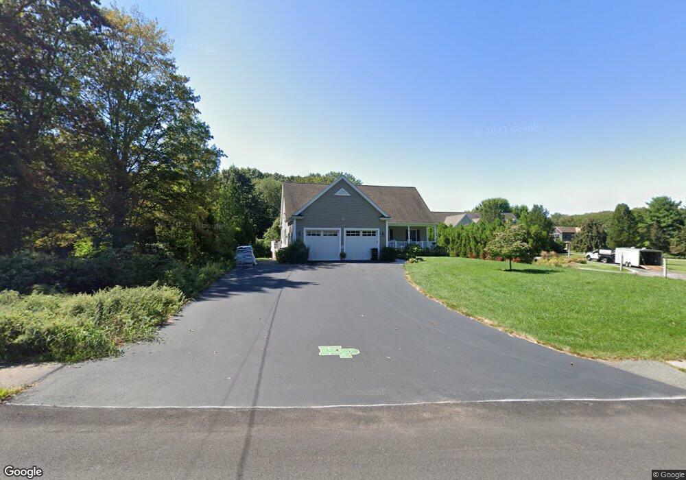
154 Thurston St Wrentham, MA 02093
Estimated Value: $618,000 - $692,000
3
Beds
2
Baths
1,044
Sq Ft
$627/Sq Ft
Est. Value
About This Home
This home is located at 154 Thurston St, Wrentham, MA 02093 and is currently estimated at $654,503, approximately $626 per square foot. 154 Thurston St is a home located in Norfolk County with nearby schools including Delaney Elementary School, Charles E Roderick, and Discovery Daycare Center.
Ownership History
Date
Name
Owned For
Owner Type
Purchase Details
Closed on
Mar 3, 2014
Sold by
Caruso John F and Caruso Arleen F
Bought by
Caruso Rt
Current Estimated Value
Purchase Details
Closed on
Apr 12, 2010
Sold by
Mccarthy Michael J and Mccarthy Antonella
Bought by
Caruso John F and Caruso Arleen F
Purchase Details
Closed on
Aug 14, 2008
Sold by
Bank Of New York
Bought by
Mccarthy Antonella and Mccarthy Michael J
Purchase Details
Closed on
Nov 16, 2007
Sold by
Pickett Lloyd E and Bank Of New York
Bought by
Bank Of New York
Create a Home Valuation Report for This Property
The Home Valuation Report is an in-depth analysis detailing your home's value as well as a comparison with similar homes in the area
Purchase History
| Date | Buyer | Sale Price | Title Company |
|---|---|---|---|
| Caruso Rt | -- | -- | |
| Caruso John F | $175,000 | -- | |
| Mccarthy Antonella | $110,000 | -- | |
| Bank Of New York | $241,526 | -- |
Source: Public Records
Tax History
| Year | Tax Paid | Tax Assessment Tax Assessment Total Assessment is a certain percentage of the fair market value that is determined by local assessors to be the total taxable value of land and additions on the property. | Land | Improvement |
|---|---|---|---|---|
| 2025 | $7,426 | $640,700 | $247,900 | $392,800 |
| 2024 | $6,787 | $565,600 | $247,900 | $317,700 |
| 2023 | $6,623 | $524,800 | $225,300 | $299,500 |
| 2022 | $6,620 | $484,300 | $202,800 | $281,500 |
| 2021 | $6,319 | $449,100 | $181,200 | $267,900 |
| 2020 | $6,360 | $446,300 | $165,300 | $281,000 |
| 2019 | $6,021 | $426,400 | $150,300 | $276,100 |
| 2018 | $5,893 | $413,800 | $150,400 | $263,400 |
| 2017 | $5,770 | $404,900 | $147,500 | $257,400 |
| 2016 | $5,689 | $398,400 | $143,300 | $255,100 |
| 2015 | $5,567 | $371,600 | $137,700 | $233,900 |
| 2014 | $5,509 | $359,800 | $132,400 | $227,400 |
Source: Public Records
Map
Nearby Homes
- 155 Clark Rd Unit 155
- 483 Thurston St
- 319 Taunton St
- 10 Nature View Dr
- 15 Nature View Dr
- 25 Foxboro Rd
- 131 Washington St Unit 42
- 131 Washington St Unit 50
- 11 Earle Stewart Ln
- 75 Foxboro Rd
- 12 Earle Stewart Ln
- 11 Weber Farm Rd Unit 11
- Lot 1 - Blueberry 2 Car Plan at King Philip Estates
- Lot 8 - Blueberry 2 Car Plan at King Philip Estates
- Lot 5 - Hughes 2 car Plan at King Philip Estates
- Lot 6 - Blueberry 3 Car Plan at King Philip Estates
- 10 Earle Stewart Ln Unit Lot 5
- Lot 2 - Camden 2 Car Plan at King Philip Estates
- Lot 7 - Cedar Plan at King Philip Estates
- Lot 4 - Hemingway 2 Car Plan at King Philip Estates
- 156 Thurston St
- 152 Thurston St
- 127 Thurston St
- 143 Thurston St
- 157 Thurston St
- 172 Thurston St
- 167 Thurston St
- 148 Thurston St
- 119 Thurston St
- 119 Thurston St Unit 1
- 138 Thurston St
- 175 Thurston St
- 300 Cowell Rd
- 320 Cowell Rd
- 310 Cowell Rd
- 33 Nadeau Dr
- 39 Nadeau Dr
- 47 Nadeau Dr
- 87 Thurston St
- 55 Nadeau Dr
Your Personal Tour Guide
Ask me questions while you tour the home.