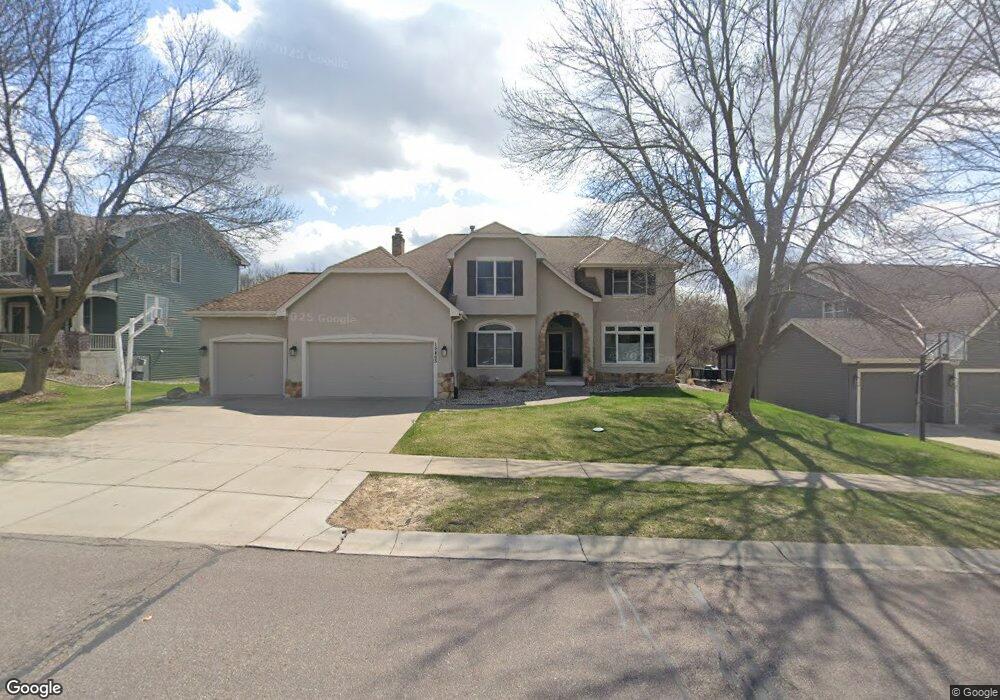
15463 Elm Rd N Maple Grove, MN 55311
Estimated Value: $703,000 - $773,000
5
Beds
4
Baths
4,044
Sq Ft
$183/Sq Ft
Est. Value
About This Home
This home is located at 15463 Elm Rd N, Maple Grove, MN 55311 and is currently estimated at $740,012, approximately $182 per square foot. 15463 Elm Rd N is a home located in Hennepin County with nearby schools including Meadow Ridge Elementary School, Wayzata Central Middle School, and Wayzata High School.
Ownership History
Date
Name
Owned For
Owner Type
Purchase Details
Closed on
Nov 1, 2021
Sold by
Daniels Jason and Daniels Mindy
Bought by
Dempsey Colin and Dempsey Kathryn
Current Estimated Value
Home Financials for this Owner
Home Financials are based on the most recent Mortgage that was taken out on this home.
Original Mortgage
$496,000
Outstanding Balance
$454,876
Interest Rate
3.05%
Mortgage Type
New Conventional
Estimated Equity
$285,136
Purchase Details
Closed on
May 31, 2011
Sold by
Batts Kenneth D and Batts Lori N
Bought by
Daniels Jason and Daniels Mindy
Purchase Details
Closed on
Aug 14, 1999
Sold by
Christensen Mitchell A
Bought by
Batts Kenneth P and Batts Lori N
Purchase Details
Closed on
Jul 18, 1996
Sold by
Lundgren Bros Construction Inc
Bought by
Christensen Mitchell A and Christensen Jodi K
Create a Home Valuation Report for This Property
The Home Valuation Report is an in-depth analysis detailing your home's value as well as a comparison with similar homes in the area
Home Values in the Area
Average Home Value in this Area
Purchase History
| Date | Buyer | Sale Price | Title Company |
|---|---|---|---|
| Dempsey Colin | $620,000 | Minnesota Title | |
| Daniels Jason | $470,000 | -- | |
| Batts Kenneth P | $385,000 | -- | |
| Christensen Mitchell A | $358,498 | -- |
Source: Public Records
Mortgage History
| Date | Status | Borrower | Loan Amount |
|---|---|---|---|
| Open | Dempsey Colin | $496,000 |
Source: Public Records
Tax History Compared to Growth
Tax History
| Year | Tax Paid | Tax Assessment Tax Assessment Total Assessment is a certain percentage of the fair market value that is determined by local assessors to be the total taxable value of land and additions on the property. | Land | Improvement |
|---|---|---|---|---|
| 2024 | $7,972 | $661,000 | $168,800 | $492,200 |
| 2023 | $7,220 | $632,900 | $140,600 | $492,300 |
| 2022 | $6,959 | $650,000 | $144,500 | $505,500 |
| 2021 | $7,153 | $542,800 | $107,700 | $435,100 |
| 2020 | $6,906 | $530,200 | $111,200 | $419,000 |
| 2019 | $7,035 | $498,000 | $102,800 | $395,200 |
| 2018 | $7,172 | $500,500 | $103,000 | $397,500 |
| 2017 | $6,836 | $471,600 | $102,000 | $369,600 |
| 2016 | $7,068 | $475,700 | $112,000 | $363,700 |
| 2015 | $6,727 | $464,800 | $118,000 | $346,800 |
| 2014 | -- | $440,300 | $125,000 | $315,300 |
Source: Public Records
Map
Nearby Homes
- 6386 Minnesota Ln N
- 6225 Vicksburg Ln N
- 16370 62nd Place N
- 6336 Yuma Ln N
- 15097 67th Place N
- 6413 Archer Ln N
- 11100 Black Oaks Ln N
- 11020 Black Oaks Ln N
- 11050 Black Oaks Ln N
- 16600 61st Ave N
- 6170 Dallas Ln N
- 16745 58th Ave N
- 6848 Polaris Ln N
- 5865 Comstock Ln N
- 13940 64th Ave N
- 5510 Weston Ln N
- 5690 Zanzibar Ln N
- 6324 Fountain Ln N
- 6245 Annapolis Ln N
- 5895 Garland Ln N