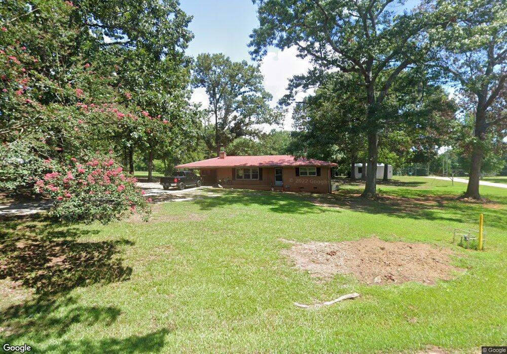
155 Sterling Dr Hartwell, GA 30643
Estimated Value: $207,000 - $304,000
2
Beds
1
Bath
1,247
Sq Ft
$193/Sq Ft
Est. Value
About This Home
This home is located at 155 Sterling Dr, Hartwell, GA 30643 and is currently estimated at $240,911, approximately $193 per square foot. 155 Sterling Dr is a home located in Hart County with nearby schools including Hart County High School and Barnes Academy.
Ownership History
Date
Name
Owned For
Owner Type
Purchase Details
Closed on
Jul 13, 2020
Sold by
Roberts Deborah B
Bought by
G2g Property Solutions Llc
Current Estimated Value
Purchase Details
Closed on
Apr 1, 1989
Purchase Details
Closed on
Aug 1, 1986
Create a Home Valuation Report for This Property
The Home Valuation Report is an in-depth analysis detailing your home's value as well as a comparison with similar homes in the area
Home Values in the Area
Average Home Value in this Area
Purchase History
| Date | Buyer | Sale Price | Title Company |
|---|---|---|---|
| G2g Property Solutions Llc | $100,000 | -- | |
| -- | -- | -- | |
| -- | $47,900 | -- |
Source: Public Records
Tax History Compared to Growth
Tax History
| Year | Tax Paid | Tax Assessment Tax Assessment Total Assessment is a certain percentage of the fair market value that is determined by local assessors to be the total taxable value of land and additions on the property. | Land | Improvement |
|---|---|---|---|---|
| 2024 | $1,261 | $81,686 | $5,832 | $75,854 |
| 2023 | $1,131 | $67,910 | $4,876 | $63,034 |
| 2022 | $979 | $58,788 | $4,300 | $54,488 |
| 2021 | $940 | $50,684 | $2,253 | $48,431 |
| 2020 | $492 | $27,426 | $4,722 | $22,704 |
| 2019 | $489 | $27,036 | $4,722 | $22,314 |
| 2018 | $514 | $27,980 | $4,722 | $23,258 |
| 2017 | $512 | $27,756 | $4,722 | $23,034 |
| 2016 | $504 | $26,591 | $3,217 | $23,374 |
| 2015 | $495 | $27,427 | $4,031 | $23,396 |
| 2014 | $465 | $25,410 | $2,638 | $22,771 |
| 2013 | -- | $26,096 | $2,638 | $23,457 |
Source: Public Records
Map
Nearby Homes
- 373 Liberty Hill Rd Unit 19
- 2077 Elberton Hwy
- 445 Liberty Hill Rd Unit 22
- 461 Liberty Hill Rd Unit 23
- 587 Liberty Hill Rd Unit 30
- 619 Liberty Hill Rd Unit 32
- 569 Liberty Hill Rd Unit 29
- 521 Liberty Hill Rd Unit 26
- 605 Liberty Hill Rd Unit 31
- 553 Liberty Hill Rd Unit 28
- 875 Benson St
- 861 Benson St
- 17 Fairview Station
- 32 Hart Terrace
- 713 Benson St
- 482 N Point Cir
- 88 Thornton Dr
- 184 Rachel Ln
- 166 Rachel Ln
- 233 Sterling Dr
- 222 Sterling Dr
- 290 Sterling Dr
- 125 Sterling Dr
- 232 Sterling Dr
- 122 Sterling Dr
- 103 Sterling Dr
- 69 Eastern Rd
- 386 Sterling Dr
- 436 Liberty Hill Rd
- 304 Liberty Hill Rd
- 54 Sterling Dr
- 115 Eastern Rd
- 562 Liberty Hill Rd
- 232 Liberty Hill Rd
- 528 Liberty Hill Rd
- 31 Sterling Dr
- 20 Sterling Dr
- 221 Liberty Hill Rd
- 186 Liberty Hill Rd