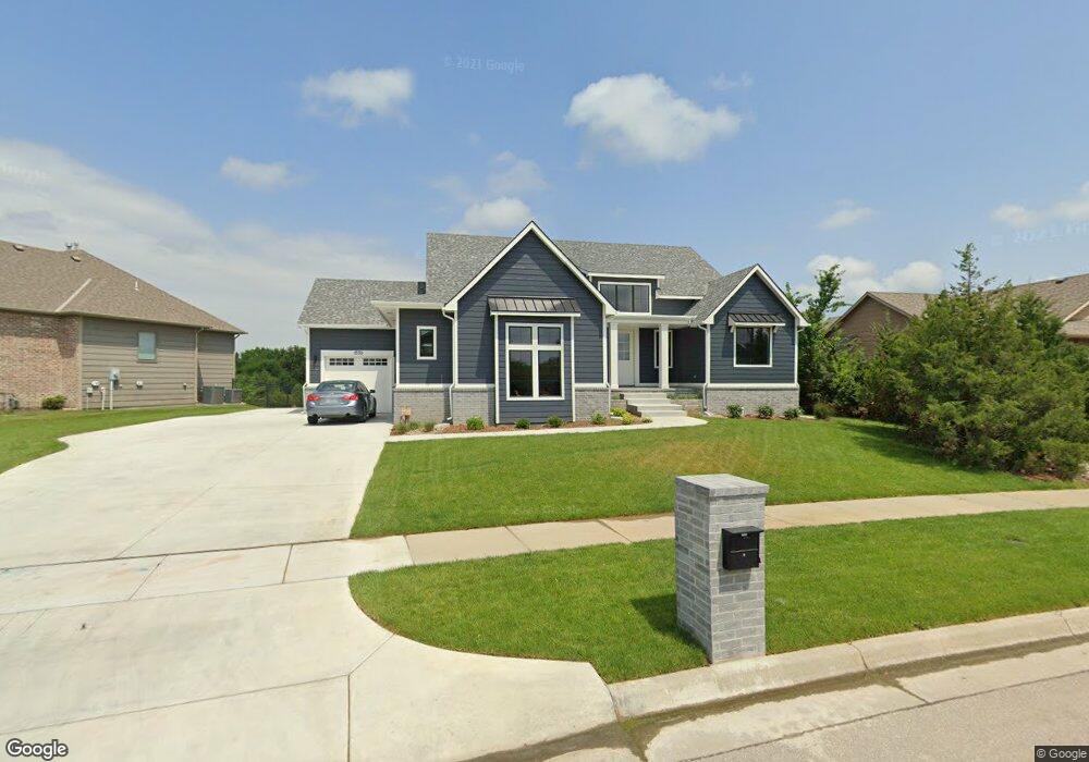
1550 N Lakeside Dr Unit LOT 1 BLOCK D Andover, KS 67002
Estimated Value: $499,000 - $643,000
5
Beds
4
Baths
1,971
Sq Ft
$302/Sq Ft
Est. Value
About This Home
This home is located at 1550 N Lakeside Dr Unit LOT 1 BLOCK D, Andover, KS 67002 and is currently estimated at $594,932, approximately $301 per square foot. 1550 N Lakeside Dr Unit LOT 1 BLOCK D is a home located in Butler County with nearby schools including South Beauregard Elementary School, South Beauregard Upper Elementary School, and Cottonwood Elementary School.
Ownership History
Date
Name
Owned For
Owner Type
Purchase Details
Closed on
May 28, 2021
Sold by
Nes Homes Inc
Bought by
Rohr Randall and Rohr Terrell
Current Estimated Value
Home Financials for this Owner
Home Financials are based on the most recent Mortgage that was taken out on this home.
Original Mortgage
$210,000
Outstanding Balance
$173,798
Interest Rate
3%
Mortgage Type
New Conventional
Estimated Equity
$421,134
Purchase Details
Closed on
Sep 18, 2020
Sold by
Shadow Rock Llc
Bought by
Nies Homes Inc
Create a Home Valuation Report for This Property
The Home Valuation Report is an in-depth analysis detailing your home's value as well as a comparison with similar homes in the area
Home Values in the Area
Average Home Value in this Area
Purchase History
| Date | Buyer | Sale Price | Title Company |
|---|---|---|---|
| Rohr Randall | -- | Security 1St Title Llc | |
| Nies Homes Inc | -- | Security 1St Title Llc |
Source: Public Records
Mortgage History
| Date | Status | Borrower | Loan Amount |
|---|---|---|---|
| Open | Rohr Randall | $210,000 |
Source: Public Records
Tax History Compared to Growth
Tax History
| Year | Tax Paid | Tax Assessment Tax Assessment Total Assessment is a certain percentage of the fair market value that is determined by local assessors to be the total taxable value of land and additions on the property. | Land | Improvement |
|---|---|---|---|---|
| 2025 | $1,155 | $76,222 | $7,316 | $68,906 |
| 2024 | $1,155 | $74,876 | $7,316 | $67,560 |
| 2023 | $1,155 | $70,219 | $7,316 | $62,903 |
| 2022 | $5,646 | $57,884 | $6,702 | $51,182 |
| 2021 | $1,155 | $25,452 | $6,702 | $18,750 |
| 2020 | $3,356 | $6,994 | $6,994 | $0 |
| 2019 | $1,155 | $6,994 | $6,994 | $0 |
| 2018 | $3,358 | $6,994 | $6,994 | $0 |
| 2017 | $0 | $6,994 | $6,994 | $0 |
| 2014 | -- | $0 | $0 | $0 |
Source: Public Records
Map
Nearby Homes
- 1609 N Lakeside Ct
- 1447 N Lakeside Dr
- 1538 N Shadow Rock Dr
- 1526 N Shadow Rock Dr
- 1611 N Shadow Rock Dr
- 1713 Terry Ln
- 420 Renee Dr
- Bedford Plan at The Courtyards at Cornerstone
- Portico Tandem Plan at The Courtyards at Cornerstone
- Portico Plus Plan at The Courtyards at Cornerstone
- Ashford Plan at The Courtyards at Cornerstone
- Salerno Plan at The Courtyards at Cornerstone
- 300 W Pepper Tree Rd
- Promenade III Plan at The Courtyards at Cornerstone
- Haven Plan at The Courtyards at Cornerstone
- Acadia Plan at The Courtyards at Cornerstone
- Clay Plan at The Courtyards at Cornerstone
- Torino II Plan at The Courtyards at Cornerstone
- Casina Plan at The Courtyards at Cornerstone
- Palazzo Plan at The Courtyards at Cornerstone
- 1550 N Lakeside Dr
- 1602 N Lakeside Ct
- 1542 N Lakeside Dr
- 616 Greenleaf Ct
- 1606 N Lakeside Ct
- 1606 N Lakeside Ct Unit LOT 3 BLOCK D
- 1532 N Lakeside Dr
- 624 Greenleaf Ct
- 615 Greenleaf Ct
- 1607 N Lakeside Dr Unit LOT 8 BLOCK D
- 1610 N Lakeside Ct Unit LOT 4 BLOCK D
- 1610 N Lakeside Ct
- 604 W Point Cir
- 1601 N Lakeside Dr Unit LOT 19 BLOCK C
- 1601 N Lakeside Dr
- 623 Greenleaf Ct
- 606 W Point Cir
- 602 W Point Cir
- 703 Greenleaf Ct
- 618 W Point Ct