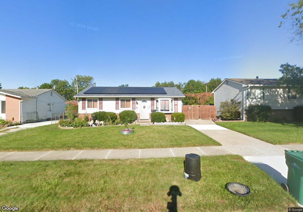
15510 Anthony St Romulus, MI 48174
Estimated Value: $188,364 - $208,000
3
Beds
2
Baths
1,034
Sq Ft
$190/Sq Ft
Est. Value
About This Home
This home is located at 15510 Anthony St, Romulus, MI 48174 and is currently estimated at $196,091, approximately $189 per square foot. 15510 Anthony St is a home located in Wayne County with nearby schools including Halecreek Elementary School, Romulus Middle School, and Romulus Senior High School.
Ownership History
Date
Name
Owned For
Owner Type
Purchase Details
Closed on
Oct 9, 2009
Sold by
Bosch Jeffrey D
Bought by
Lazere Ii Robert K
Current Estimated Value
Purchase Details
Closed on
Apr 2, 2004
Sold by
Mcdougall John A and Mcdougall Pamela J
Bought by
Bosch Jeffrey D
Purchase Details
Closed on
Jul 5, 2001
Sold by
Loeman David F
Bought by
Kinsely Pamela J
Purchase Details
Closed on
Apr 28, 2000
Sold by
Loeman David F
Bought by
Loeman David F
Create a Home Valuation Report for This Property
The Home Valuation Report is an in-depth analysis detailing your home's value as well as a comparison with similar homes in the area
Home Values in the Area
Average Home Value in this Area
Purchase History
| Date | Buyer | Sale Price | Title Company |
|---|---|---|---|
| Lazere Ii Robert K | $58,300 | None Available | |
| Bosch Jeffrey D | $138,000 | Multiple | |
| Kinsely Pamela J | $117,500 | -- | |
| Loeman David F | -- | -- |
Source: Public Records
Tax History
| Year | Tax Paid | Tax Assessment Tax Assessment Total Assessment is a certain percentage of the fair market value that is determined by local assessors to be the total taxable value of land and additions on the property. | Land | Improvement |
|---|---|---|---|---|
| 2025 | $1,920 | $87,400 | $0 | $0 |
| 2024 | $1,929 | $81,900 | $0 | $0 |
| 2023 | $1,863 | $72,600 | $0 | $0 |
| 2022 | $2,180 | $66,500 | $0 | $0 |
| 2021 | $2,121 | $54,200 | $0 | $0 |
| 2020 | $2,080 | $53,400 | $0 | $0 |
| 2019 | $2,079 | $45,100 | $0 | $0 |
| 2018 | $1,392 | $34,200 | $0 | $0 |
| 2017 | $976 | $33,800 | $0 | $0 |
| 2016 | $1,832 | $35,500 | $0 | $0 |
| 2015 | $3,420 | $34,200 | $0 | $0 |
| 2013 | $3,360 | $36,600 | $0 | $0 |
| 2012 | $1,106 | $35,200 | $4,800 | $30,400 |
Source: Public Records
Map
Nearby Homes
- 15521 Brandt St
- 15520 Brandt St
- 30455 Cherry Ave
- 30058 Halecreek St
- 15900 Sandburg St
- 30771 Halecreek St
- 16068 Middlebelt Rd
- 16110 Farnum St
- 15715 Merriman Rd
- 00 Eureka Rd
- 30620 Pennsylvania Rd
- 15654 Isabelle St
- 30930 Pennsylvania Rd Unit 8
- 28567 Forest Dale St
- 00000 Pennsylvania Rd
- 28510 Halecreek St
- 29067 Cullen Dr Unit BLDG8
- Lot 106 Hollywood
- Lot 107 Hollywood
- 00000 Huron
- 15498 Anthony St
- 15522 Anthony St
- 15486 Anthony St
- 15534 Anthony St
- 15549 Brandt St
- 15561 Brandt St
- 15535 Brandt St
- 15511 Anthony St
- 15575 Brandt St
- 15499 Anthony St
- 15546 Anthony St
- 15523 Anthony St
- 15589 Brandt St
- 15474 Anthony St
- 15487 Anthony St
- 15507 Brandt St
- 15460 Anthony St
- 15537 Anthony St
- 15608 Anthony St
- 15475 Anthony St Unit Bldg-Unit
Your Personal Tour Guide
Ask me questions while you tour the home.